DISPATCHER'S | R E T U R N - TO - M I S T Y - M O O R I N G S |
|
|
| RIBBON |
B R I E F I N G |
0 Kake SPB (KAE) |
This dispatch takes you around Admiralty Island (the island just south of Juneau). There are 12 locations we will visit on this tour of the island. Many screenshots have been added to help with your navigation and "finding" of the cabin locations. We also employ the RTMM GPS WayPoints for these. Often you will not need them if you follow the VFR instructions. We start at KAKE taking off to the north flying over Point White and Point Macartney, then on to Elliot island. Enjoy. |
| 1 Pybus Bay USFS Cabin ------ Direct Heading: 319 Distance: 24 m Way Point: R513A See Dispatch Map |
Set GPS for R513A and the altitude to 1200 feet. Flying the 118 heading, you will first fly over Point White and 2 miles further over Point Macartney where you will turn to a heading of 337 for 14 miles to Elliot Island. Over Elliot island, you turn to a heading of 317, you are entering Pybus Bay. Ahead is a peninsula with a small bay coming in from port. This is Henry's Arm. Over this feature, turn to 278, the cabin is 2 miles ahead, assume landing configuration. (Cabin Approach) There is a small island between you and the cabin ... fly to the starboard side of the island, land there and taxi to port to the cabin. |
| 2 Jim's Lake USFS Cabin ------ Direct Heading: 322 Distance: 15 m Way Point: R445A See Dispatch Map |
Take off from Pybus Cabin on a heading of 360. Set the GPS for Jim's Lake Cabin R445A. Jim's Lake Cabin is about 14 miles ahead. When you see a gap in the mountains, be prepared to increase your altitude to about 2000 feet, jog port, then back to starboard and you should be lined up on Jim's Lake.
As you approach the lake, the cabin will be on the far end. |
| 3 Sportsman Lake Cabin ------ Direct Heading: 292 Distance: 5 m Way Point: R541A Way Point: R409A See Dispatch Map |
Leaving Jim's Lake, taxi back out toward the center of the lake, then take off toward Jim's Lake Cabin on the shore and fly over it. (Approach) Set your GPS for R541A for Sportsman Lake Cabin. There are two cabins near each other on this lake, Sportsman Lake Cabin and Distin Lake Cabin. Fly first to Sportsman, then taxi or short hop on down to Distin Lake Cabin, (GPS R5409A) also on the starboard shoreline. |
| 4 East Florence Lake Cabin ------ Direct Heading: 331 Distance: 12 m Way Point: R415A |
Set the GPS for R415A, Florence Cabin. If you look at the map on the GPS, you'll see if you fly a little to the west, there is a nice valley that takes you up toward the cabin. Fly roughly 240 degrees to angle up toward that wide valley, which you will acquire just after crossing Thayer Lake. Fly the valley all the way to the sea and when you reach the sea, turn to the starboard shore and look to starboard, you should see East Florence Lake. Turn onto the lake. (Reset the GPS, [Direct]-Ent-Ent). The Cabin is at the far starboard shore of the lake. |
| 5 Lake Kathleen Cabin ------ Direct Heading: 323 Distance: 6 m Way Point: R466A See Dispatch Map |
Take off from Florence Lake toward the west, heading back to the sea. When you get to the coast, turn to starboard and follow the coastline. Keep looking to your starboard side and you will see the lake, about a mile inland. Turn toward and land on the lake. The mooring for the cabin is on the far end of the lake. You can land with wheels at this location as the cabin is some distance from the mooring and the landing zone is very flat. |
6 Hawk Inlet SPB (HWI) |
Half way up the Hawk Inlet, you will see the Hawk Inlet SPB. It is always worth a stop and a visit, a nice half-way stop for lunch. If you are lucky, you will see the "live" Coast Guard Cutter that docks there. Airport Information: spb airport, Hawk inlet is not just the place for sightseeing, but it also enables you to steal a self-indulgent moment for yourself as well. So, check out the spb airport tourist spot for all the attractions that is on offer and visit this spot on weekends for a rejuvenating time. World standards, extraordinary architecture, innovative layouts, and well-thought execution make place a highly coveted point of tourist interest. Do not forget to carry your camera and capture special moments. spb airport, Hawk inlet is the sure way to refresh and relax after a busy weekday. Explore interesting themes, fabulous designs, colorful landscapes, amusing characters, ambient music, props and merchandise available in nearby stores- all at one place. spb airport, Hawk inlet is the best way to have a memorable time with kids and family. So, enjoy a fulfilling outing at spb airport in Hawk inlet. |
7 Admiralty Cove Cabin |
As we did at Florence Lake, leaving Kathleen Lake, turn to the west and fly back the length of Kathleen Lake to the sea. At the coastline, turn to starboard and follow the cost. Set your GPS for R366A for Admiralty Cove cabin. This is on the northern shore of Admiralty Island. Fly up the coast for about 8 miles and you will encounter Hawk Inlet. Fly the inlet to the north coast of the island, about 5 miles. About halfway up the inlet, you will fly over Hawk Inlet SPB. When you reach end of the inlet, turn 90 to starboard. Admiralty Cove is dead ahead (see approach). (Reset your GPS [Direct]-[Ent]-[Ent]..it will point to the cabin). As you approach, you will see an "inner cove". That is where the cabin is located. |
8 Young Lake Cabins |
There are two cabins on Young Lake, North, and South. We will be flying first to the NORTH cabin (R493A). Taxi west along the shore until you have enough room to take off to the south. You will be flying over the flat area there which holds Admiralty Creek and follow it to Young Lake. The North cabin is on the first shoreline as you cross over the lake.
You can then "short hop" down the lake, heading south (or taxi if you like - GPS R539A) and you will arrive at the Young Lake South Cabin on the southeastern corner of the lake. |
9 Big Shaheen Cabin |
Taxi north on Young lake to give your self sufficient take-off room to fly to the south. We are now flying to the Shaheen Cabins. There is a "BIG" and a "LITTLE" and they are basically side by side. Set your GPS for R296A (Big Shaheen Cabin). We will fly south for 26 miles. From Young Lake, fly the valley south until you reach the water, follow the water to Windfall Harbor, where you will turn INTO the harbor. Fly to the end of the harbor and continue down the valley. At the end of the valley continue straight, but watch to the right for the beginnings of Hasselborg Lake. Fly out over Hasselborg Lake and continue south. You will see a "narrows" ahead. The cabins are located on the port shoreline just after the narrows. The Shaheen Cabins are side-by-side. |
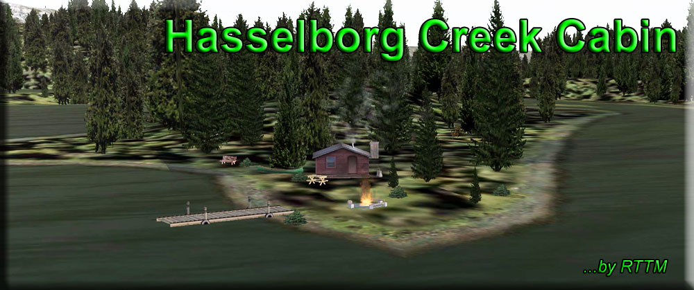
10 Hasselborg Creek Cabin |
When leaving the Shaheen Cabins, set your gps for R436A, Hassenborg Creek Cabin. It is a 3 mile "short hop" down to the southwest corner of the lake where the cabin is located. This is a bit tricky, you have to land out on the lake just outside the outfall of Hasselborg Creek, then taxi up the creek to a beautiful little cabin, nestled back in the inlet.
To leave, taxi back out to the creek outfall into the lake. Take off at about 64 degrees, stay low and slow, the cabin is just 2 miles ahead. |
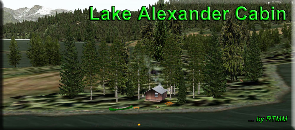
11 Lake Alexander Cabin |
If you fly direct from Hasselborg Creek to the Lake Alexander Cabin, you will be coming in at a heading of about 50 degrees. When you see Lake Alexander, you'll see a peninsula about mid-lake. The Alexander Lake Cabin is on the starboard side of that peninsula. (Approach) Leaving Lake Alexander, set your GPS for R334A (Church Bight Cabin) and fly south out of the lake. |
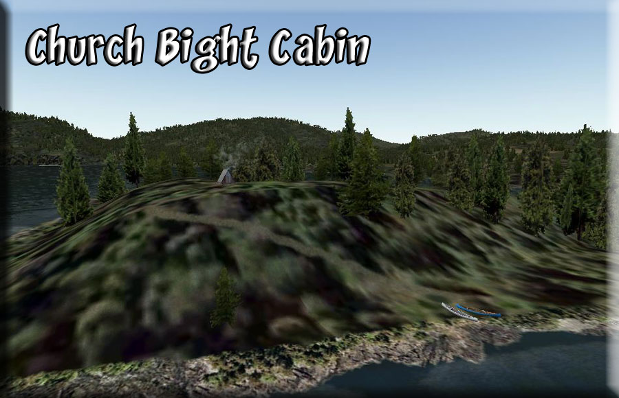
| 12 Church Bight USFS Cabin ------ Direct Heading: 129 Distance: 16 m Way Point: R334A See Dispatch Map |
As you leave Alexander Lake, you can reset your altitude for 1200 feet and set a new heading of 65. The cabin is located on the peninsula coming out from the starboard shore of the cove ahead. Fly to the coast line. Follow the shoreline for a few miles, then reset the GPS to give you a direct course to the cabin. ([Direct]-[Ent]-[Ent]). Fly straight to the cabin.This can be surprisingly difficult to locate even though it is out in the open. It is a tiny "A" Frame cabin on the bluff on a small peninsula coming out from the starboard shoreline. |
| 0 Kake Seaplane Base (KAE) ------ Direct Heading: 159 Distance: 27.2 Way Point: KAE |
Leave Church Bight Cabin by taking off on a heading of 100 degrees. (Watch for the small islands in this cove!). Set your altitude to 1200. Once over the coastline, turn to a heading of 112 to follow the coast, 2 mile ahead as the coast turns to starboard at False Point, set your heading for 162 for "The Brothers" the West Brother Island will pass just to port. As you pass the Brothers Islands, set a heading of 175. Fly this heading for 15 miles to cross over Macartney Point, come to port to pass over White Point. Set up a heading to land at the Sea Plane Base at Kake 5 miles ahead. Just parallel the shore to port to set up your landing. We hope you enjoyed the dispatch. You can send any comments you have using the address below. |

Copyright Return to Misty Moorings 2021
|