DISPATCHER'S | R E T U R N - TO - M I S T Y - M O O R I N G S |
|
|
| RIBBON |
B R I E F I N G |
1 Misty's Place |
The USFS Ranger gave you a call yesterday and wanted to know if you'd like to do a Cabin Inspection Tour with him in the Prince of Wales area. ("Of Course! Yes!). We start at Misty's Place, our choice of plane depends on the season. In winter, Josephine Lake is "ice" ... so an amphibian would be better. If a float plane, you can start from the dock, if an amphibian, the runway, or slide into the water at the Misty's Place ramp and take the Misty Canal (Bostwick Creek) to the take-off area. (put water rudders down, hit water with a little speed turn to starboard hard. Take the starboard channel to the lighthouse area). |
| 2 Trollers Cove Cabin USFS ------ Direct Heading: 272 Distance: 15.8 m Way Point: R554A |
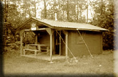
We are heading first for Trollers Cove. The "easy" way is to fly 315 from Misty's Place for 8 miles to Vallener Bay then turn to port to a heading of 242 for 12 miles. (tip: reset gps, on gps, select "[D]irect/enter/enter ... gives you a new direct route to the way point). We'll cross the Clarence Strait and look for Trollers Cove on the coast. With low clouds, turn a little to starboard and go around Island Point keeping the shore to port. As you round the point, be in landing configuration and low. You will see a cove to port, and a point ahead. Fly around the coming point to port and you will be lined up for the Trollers Cove Cabin on the port shore. (Watch for the sand bars). We check the cabin grounds and prepare for a trip to Karta Lake. |
| 3 Karta River Cabin USFS ------ Direct Heading: 290 Distance: 18.0 m Way Point: R455A |
(Set your way point) With a quick inspection of the cabin and a chat with the temporary residents, we determine all is well, sign the check off sheets and take off for Karta Bay. We taxi about 340 past the sand bar then take off on a heading of 290. As you approach, you may want to swing to starboard over Sandy Point and into Karta Bay. You will pass over a Brad's BBQ, continue along the port shore and it will guide you to the cabin on the starboard shore. This would be a great place for fishing up the Karta River! (You can always short-hop back to Brad's BBQ for a snack). |
| 4 Goose Bay Cabin RTTM ------ Direct Heading: 141 Distance: 10.6 m Way Point: R146A |
Now we are heading to Goose Bay Cabin by RTMM (There is a Goose Bay Cabin USFS, far north). This is an RTMM cabin that called in a problem yesterday, so we added them to the list. We taxi back onto Karta Bay (heading 340) take off and make a slow turn back to a heading of 141, Goose Bay is only 10 miles ahead. The cabin is on the point separating Polk Inlet (to starboard) and Goose Bay (to port). We fly to the point and land near the cabin and tie up at the pier. Their problem is a pesky skunk that has a family under the porch! The Ranger gave them advice on solving the problem. both husband and wife are pilots so we had a nice chat about flying Misty Fjords ... they enjoy their pontooned Cub you see at the dock almost every day! Nice Folks make this job fun! |
| 5 Dog Salmon Complex RTTM ------ Direct Heading: 163 Distance: 2.2 m Way Point: R124A |
Since we are in the area, we decided to check on the Dog Salmon Complex just up Polk Inlet. We taxi out and set a heading of about 200. We'll fly low with flaps, We fly around the point ahead (to port) then go straight across Polk Inlet to Dog Salmon Village. We stop and ask if anything is going on in the area, all well, we taxi ahead, keeping off the starboard shore to visit Dog Salmon Creek ... they've got the smokers going ... how about a bite of smoked salmon? We radio in our position and report, and head for Josephine Lake. |
| 6 Josephine Lake Cabin USFS ------ Direct Heading: 175 Distance: 6.3 m Way Point: R447A |
Josephine Lake is at about 1600 feet in altitude, it freezes in the winter, so you have to land on the ice. You'll want to gain that altitude over the 6 mile journey. For us today, this was "dicey" ... lots of clouds, we had to make two passes finally finding a gap in the clouds and a glimpse of the lake, we flew through the hole and landed safely. Checked out the cabin, discarded a few stray limbs that had fallen, then headed back to the aircraft to head for Keegan Cove. |
| 7 Kegan Cove Cabin USFS ------ Direct Heading: 115 Distance: 18.4 m Way Point: R457A |
We take off away from the cabin, gain altitude and come to 115. Hetta Lake passes to starboard. Safe altitude in this area is about 4500 feet. If the weather is bad, you will have to "pick" your way thorough them. In "low" weather, fly past the Cabins ... out over the water it is safer to come down and come back toward them (hopefully) under the cloud ceiling. Out over Moria Sound, approach Keegan Cove at a heading of 340. Land in Keegan Creek, check the cabin. |
| 8 Kegan Creek Cabin USFS ------ Direct Heading: 049 Distance: 0.5 m Way Point: R458A |
To go to Keegan Creek ... we suggest WALKING! But if you want to fly it, go to the opposite side of the cove the Keegan Cove cabin is on. Line up on a heading of 238. Take off heading for the cabin, clear the ridge line, then be ready to come right back down .. Keegan Creek Cabin is only .5 miles away! (Uh, still got your breakfast?) Land beyond the cabin. Climb the hill, meet the people check around the cabin ... all is well, call it in, let's head home! |
| 1 Misty's Place ------ Direct Heading: 023 Distance: 20.1 m Way Point: PF20 |
To get to Misty's Place, we fly back across the Clarence Strait. It's a 20 mile flight. The "easy" way is to fly to Dall Head and around the point there, into the Nichols Passage, then turn to port into Bostwick Inlet just past Seal Point. Misty's Place is ahead. We land and taxi up the "Misty Canal" (Bostwick Creek) and climb out of the water between the white signs and taxi to the hanger. What a great day ... some scary moments, but that is all in a typical day for the USFS personnel! Your turn to buy the beer! And you do. Hope you enjoyed the flight. |
 |
Dispatch Notams
|
Copyright Return to Misty Moorings 2011

