DISPATCHER'S | R E T U R N - TO - M I S T Y - M O O R I N G S |
|
|
| RIBBON |
B R I E F I N G |
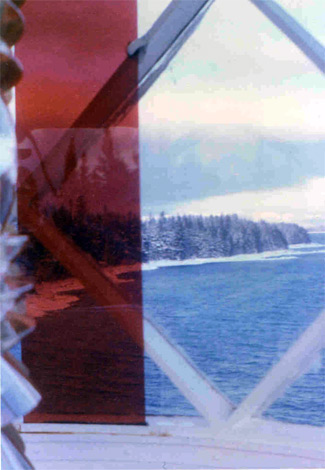
Ocean Falls SPB - CAH2 |
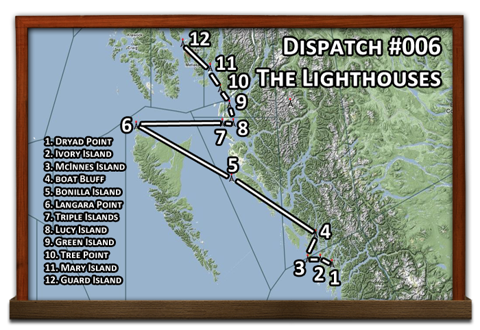
This Dispatch is a tour of the lighthouses of the RTMM area. We will start out at Ocean Falls, BC Sea Plane Base at the dock. (Enter the mooring point to the left in the MAP of FSX and you'll be at the dock ... altitude ="0" Mag Heading = "239" ). Helicopters start at: N52 21.15 W127 41.53 Mag 205. You are flying a group of "Friends of the Lighthouse" members who have come to see all the lighthouses in this area. Your job in this dispatch is to fly them to each one, let them take pictures and walk around ... then take them to the next one. We will eventually land at Ketchikan (PAKT) where they will take a commercial flight home. There is a lot of over-water flying time, to pass that time, click on any of the links for the lighthouses to see REAL information on each of them. |
| 1 Dryad Point Lighthouse ------ Direct Heading: 214 Distance: 16.9 m Way Point: R641A |
Take off straight ahead toward Coolidge Point (ahead to port .9 miles). (If you are flying to the way point, 3500 feet is the safe altitude). Fly to port around the point and fly a rough heading of 187 down the Cousins Inlet... stay low as the scenery is beautiful. You'll stay in this channel for about 12 miles. A channel comes in from starboard, turn toward it, but do not turn into it, go over 3 little islands on a heading of 222 this takes you to a smaller channel straight ahead. The channel bends to starboard, follow it. Coming out of the channel, set a heading of 260 over Gunboat Passage. The lighthouse is 5 miles ahead on the far shore. (Dock at Dryad Light) |
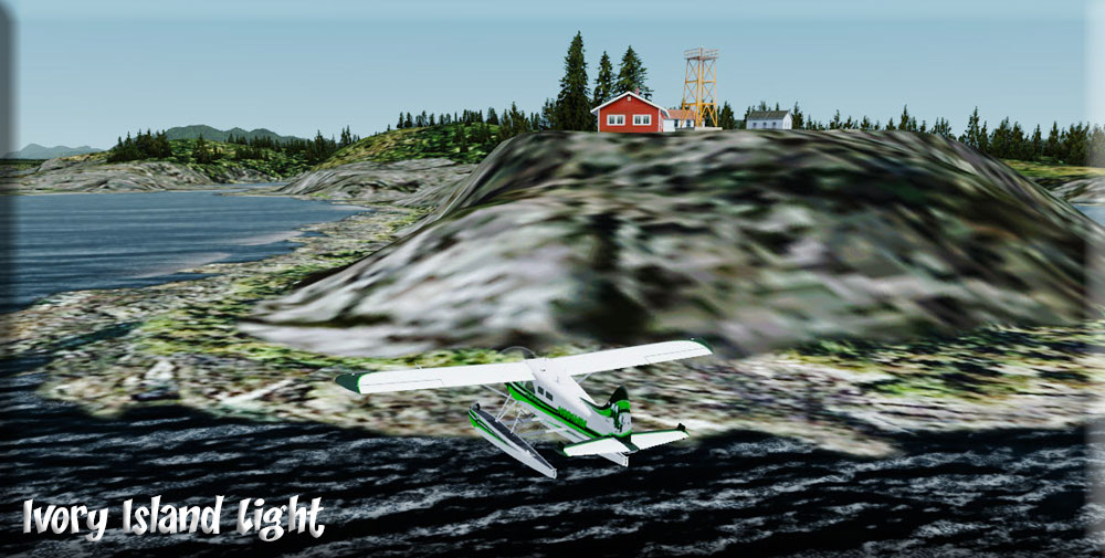
| 2 Ivory Island Lighthouse ------ Direct Heading: 275 Distance: 11.6 m Way Point: R642A |
We now head for the Ivory Island Lighthouse. We take off on a heading of 320, parallel to the shoreline until we reach a little altitude (remember don't go too high, these folks are 'flight-seeing' too). Then bring your heading to 275 for 11 miles to Ivory Island. You are flying over the Seaforth Channel. The lighthouse comes into view and you land, beaching the pontoons so your tour group can climb up the hill and visit the lighthouse. (Beached at Ivory Island) |
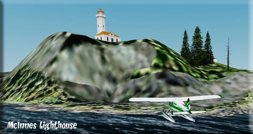
| 3 McInnes Island Lighthouse ------ Direct Heading: 247 Distance: 11.0 m Way Point: R643A |
Our tour group comes back aboard and we taxi out to set a takeoff heading of 247 ... we'll hold this heading for 11 miles watching for tiny McInnes's Island. Again, you can stay low for this flight ... nothing out here but birds (if you are seeing fish, you are too low). You will see a peninsula of land coming up to starboard. Fly for the port tip of that land mass, McInnes Island is about a mile from point. You'll find a group of islands. Fly over the first one and land beyond. The Lighthouse is on the next island straight ahead. You can beach the pontoons and your group can walk up the hill. |
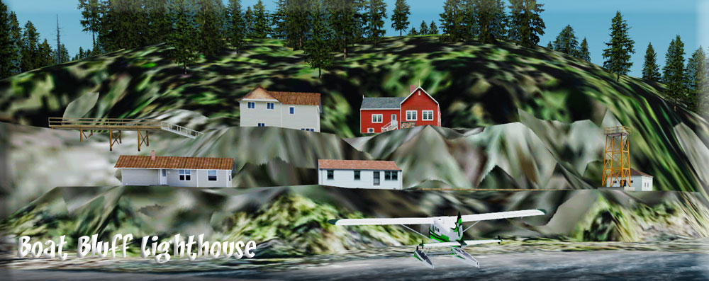
| 4 Boat Bluff Light Station ------ Direct Heading: 357 Distance: 23.0 m Way Point: R595A |
We are now heading for the Boat Bluff Light Station. (Using Way Point, safe altitude is 3000'). We'll go the Scenic route. Taxi around to the other side of the island to be able to line up a take off for 023. Give your group a chance to take some pictures, the lighthouse is impressive from this angle. Fly 15 mile on the 023 heading. We are flying over Milbank Sound. The waterway ahead splits, we will take the port channel, Jackson Passage, the channel to starboard is the Oscar Passage. Stay about a half mile of the port shore of the Jackson Passage ... the light station is 10 miles ahead. Pass close to Cone Island off the port wing, the light station will be 6 miles ahead. At the end of Cone Island, you'll see little Jane Island. Fly to the right of Jane Island, keeping the shore close to port, the light station is 1 mile ahead. Beach the pontoons. |
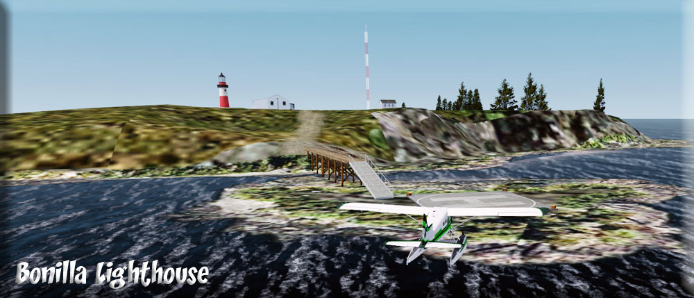
| 5 Bonilla Island Lighthouse ------ Direct Heading: 284 Distance: 91 m Way Point: R645A |
Bonilla Island Lighthouse is next. (Safe Altitude for Way Point is 3500') We take off from this area and set a heading of 284 having to gain some altitude to make it over the mountains here. This works on a clear day. With clouds, take off heading 325 to the end of the point to port ahead, that is Split Head, Turn hard to port back to a heading of 168 ... follow that till it turns 90 degrees to starboard, follow that to the end. Coming out of the channel, we'll follow a "general" 270 heading later correcting to 290. Stay near the port shore. When the island to port passes, another small island is ahead. Keep its short just to port and when you start to leave the island, set your heading on 290 ... this is a straight heading to the Bonilla Island Lighthouse 60 miles ahead. This long island you pass to starboard is Banks Island. You will see Dome Hill, the center of Bonilla Island from some miles away. Fly to the westward side of the island, the lighthouse is on the north west shore. Fly straight at the lighthouse, watch out for the islands. When you land go to the right around the island to the pier there at the helipad area. |
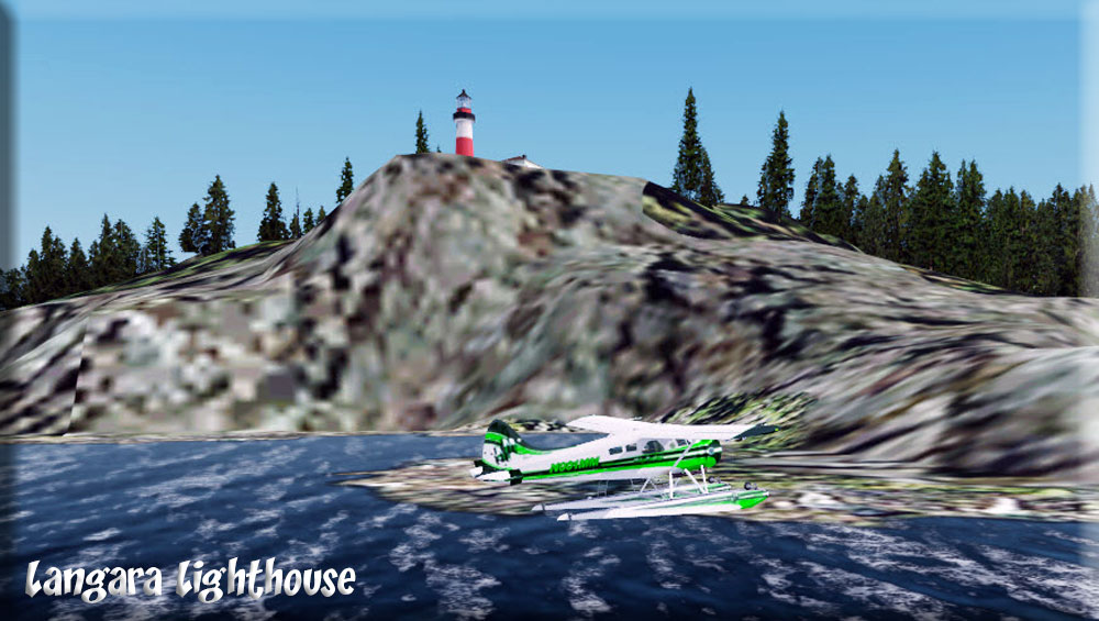
| 6 Langara Point Lighthouse ------ Direct Heading: 278 Distance: 96 m Way Point: R646A |
Taxi until you are clear of the island and can set a take off on a 278 heading. Set the autopilot for 278 at 1000 feet, sit back and relax ... a 90 mile trip ahead. On these long legs, it is a great time to click on the links on the lighthouse names in the Dispatcher's Ribbon and read about them. We fly over the north end of Graham Island going to Langara Point, tat the most northwest point on the island. (If you need fuel, Masset airport will come up on your starboard wing, ICAO is CZMT. Fly around the right side of Lagara Point. Land near the lighthouse. |
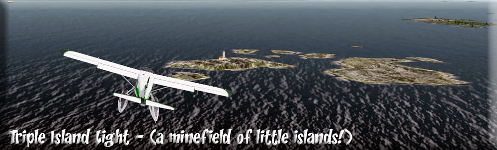
| 7 Triple Island Lighthouse ------ Direct Heading: 066 Distance: 75 m Way Point: R647A |
We taxi to a place where we can take off safely and come to a heading of 066 which we will hold for 75 miles. On a clear day you can see the southern end of the Prince of Wales Island to port. As we approach Triple Island Light, it is easy to understand why a lighthouse was needed here, this is a "minefield" of islands for surface traffic! The tour group is invited to a meal so we can relax a little after the 3 long legs. Ahead, shorter legs, more "activity." |
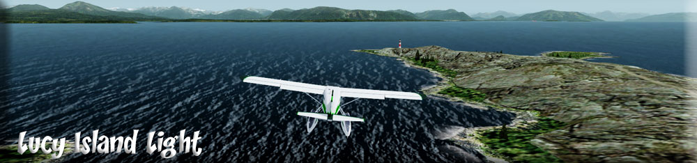
| 8 Lucy Island Lighthouse ------ Direct Heading: 070 Distance: 9.4 m Way Point: R648A |
We set a heading of 070 for the Lucy Island Lighthouse. This is only a 10 mile leg, no need for altitude. We are flying over the Brown Passage. Prince Rupert is about 20 miles ahead and a little to starboard if you need fuel. These little islands are really beautiful. There's a helipad near the lighthouse. Our group strolls around the grounds taking pictures, then we load up for Green Island Lighthouse. |
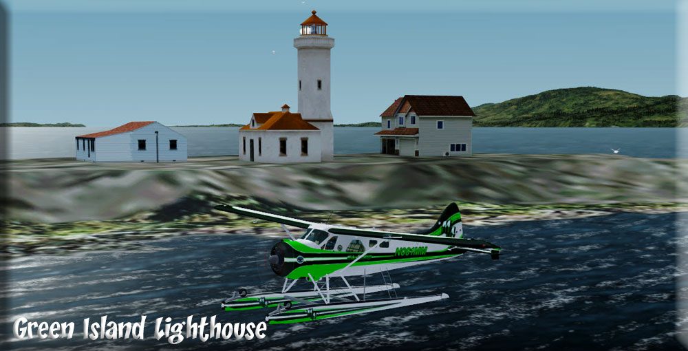
| 9 Green Island Lighthouse ------ Direct Heading: 323 Distance: 16 m Way Point: R649A |
We take off on a 323 heading that will take us directly to the Green Island Lighthouse, 16 miles ahead. Melville Island comes up to port, then Dunrick Island (looking like it is part of Melville) then the little Moffit islands showing like barrier islands along the eastern shore of Dunrick. We are flying over the Oriflamme Passage. The lighthouse is on a very tiny island ... can you imagine what it must have been like living out here? Well you can ask . As of this writing, the principal light keeper is Serge Pare and you can ask him in an e-mail message here. |
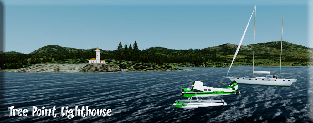
| 10 Tree Point Lighthouse ------ Direct Heading: 310 Distance: 16 m Way Point: R650A |
After having a nice discussion with Serge, and a spot of red wine, our group climbs back aboard the aircraft looking forward to seeing the "neglected" Tree Point Lighthouse, only 16 miles on up the passage. The Lighthouse is located on the starboard shoreline where the point of the Tree Point Peninsula juts out into the ocean. This one is in real disrepair, what a shame. Even the helipad was washed away in 1966. The "Friends of the Lighthouse" are taking many notes! We are invited for cocktails onto a beautiful schooner moored just off the lighthouse ... great discussions about lighthouses and history. At last, back to the aircraft and off to Mary Light. |
| 11 Mary Island Lighthouse ------ Direct Heading: 312 Distance: 19 m Way Point: R651A |
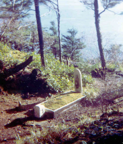
About 15 miles ahead, little Mary Island comes up to port. The Lighthouse is on the eastern shore. This guides to ships to the safer and deeper Ravillagedo Passage (the passage to port is called Danger Passage ... so many small rock islands. Mary Light guided the ships away from those hazards. A group member pointed out two little-known facts regarding the station: a red sector and a grave. The red sector, a narrow pane of ruby glass placed in the lantern room, warned vessels of Twin Islands, a navigational hazard located just over three miles north of the lighthouse. The grave of Edward Pierce, the son of an early light keeper, is located on a small bluff just south of the station. Reportedly, bad weather and the remoteness of the station prevented the boy from receiving needed medical attention |
| 12 Guard Island Lighthouse ------ Direct Heading: 292 Distance: 32 m Way Point: R652A |
At last we head for our final destination, the Guard Island Lighthouse. Along the way you can point out Herring Bay to starboard, little Dairy at Mountain Point and of course all the sights to see as you pass through the Tongass Narrows with Ketchikan passing to starboard. About 3 mile out of the Narrows, we land near the Guard Island Lighthouse. The final entry in the station’s Register of Visitors, made on July 31, 1960 by William McKey, reads “Disestablished Guard Island Light at 14:45 this date.” Thus ended the reign of keepers on the island. The vacant buildings repeatedly fell victim to vandals in the “hippie sixties,” prompting the Coast Guard to dynamite the outbuildings and keeper’s dwellings to rubble. You can see why we need organizations like Friends of the Lighthouse! |
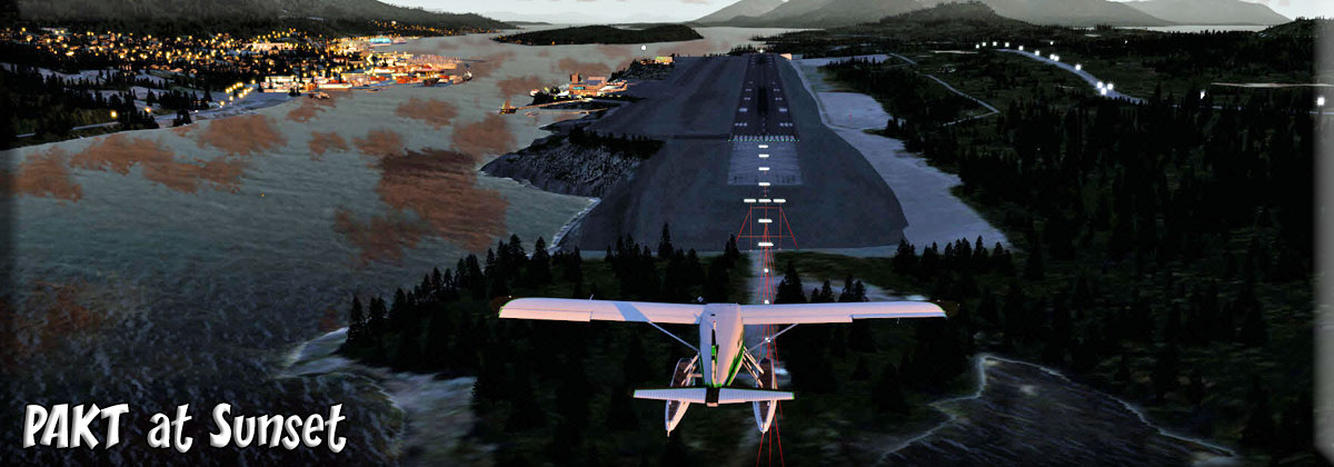
| Ketchikan Airport (PAKT) ------ Direct Heading: 111 Distance: 10.5 m Way Point: PAKT |
From the Guard Lighthouse, it is only a short hop to PAKT, the Ketchikan Airport. Our group leaves the plane with many pictures, with some new insights of what must be done and an even greater determination to continue their efforts with the Friends of the Lighthouse organization. Hopefully, if you took some of the 'flying time" to read about the lighthouses, you too will come away from this experience with your own thoughts and memories. |
Copyright Return to Misty Moorings 2021
|