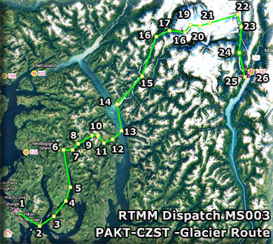
Flight Map
Flight Plan
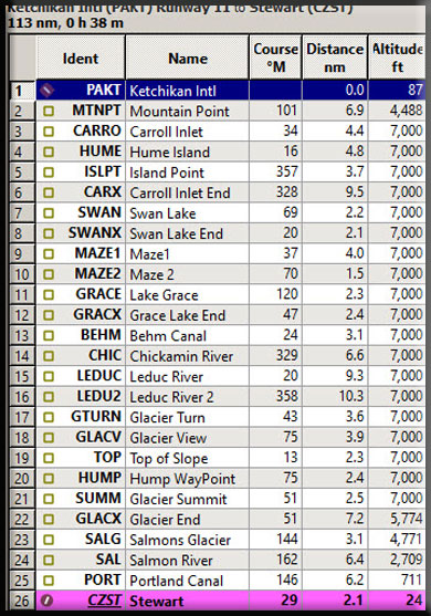
Dispatch Setup
- Suggested Altitude: 1800' then 7000'
- Landing zone is: Land
- Aircraft Type: Wheeled Aircraft
- Distance approximately: 113 nm
- Estimated Flight Time: One Hour
- Autoroute Flight Plan (.pln) HERE
- Dispatch Usage Instructions HERE
- Dispatch Video Demo HERE
NOTAM: When you are "down" the dispatch and need to see the map, click on the "Leg" Link and it will open the map, click your "back' button for it to disappear.
Dispatch Overview
This is a "Flight-Seeing" tour from Ketchikan (PACK) to Stewart (CZST). This route gives you a good view of the Misty Fjords National Monument area. The route can be flown at "low and slow" 1800' altitude except in two places ... at "Maze 2" (The Ridge) needing 2400' and of course the glacier summit that needs 7000' for a safe altitude. The flight ends by a nice long glide slope down from the glaciers out and over the Portland Canal and into Stewart.
NOTAM: Clicking on "Leg" will bring up the overall flight plan map. Then you can return to the dispatch document by clicking on the <- button.
Leg #01: To "MTNPT" (Mountain Point)
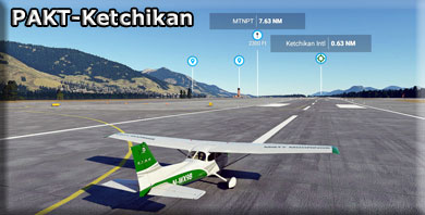
We start at PAKT (Ketchikan). We are going to be reaching an altitude of 6500' feet so choose an "appropriate" aircraft to handle the altitude. (And wear something warm!) We take off from PAKT heading for Mountain Point
- Ketchikan Creek served as a summer fish camp for Tlingit natives for untold years before the town was established by Mike Martin in 1885. He was sent to the area by an Oregon canning company to assess prospects. He established the saltery Clark & Martin and a general store with Nova Scotia native George Clark, who had been foreman at a cannery that burned down.
Ketchikan became known as "Alaska's first city" due to its strategic position at the southern tip of the Inside Passage, connecting the Gulf of Alaska to Puget Sound.
- In 1905 a mission house was built, which in 1909 became the Yates Memorial Hospital. In 2020, the National Trust for Historic Preservation named the former hospital as one of America's most endangered historic places.
- Ketchikan has the world's largest collection of standing totem poles, found throughout the city and at four major locations: Saxman Totem Park, Totem Bight State Park, Potlatch Park, and the Totem Heritage Center. Most of the totems at Saxman Totem Park and Totem Bight State Park are recarvings of older poles, a practice that began during the Roosevelt Administration through the Civilian Conservation Corps. The Totem Heritage Center displays preserved 19th-century poles rescued from abandoned village sites near Ketchikan. The Chief Kyan pole in Whale Park in the city center is one of the featured background images in most US passports.
Leg #02: To "MTNPT" (Mountain Point)
Heading: 101*
Distance: 8.9 nm
Altitude: 1800'
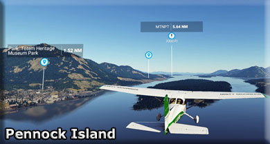
We fly out over the Tongass Strait and over Pennock Island that sits in the middle of the strait, pictured above. Our heading is toward Mountain Point, the next point of land to port. We will be rounding that point and heading for the Carroll Inlet.
- Named in 1883 by Lieutenant Commander H. E. Nichols, U.S. Navy (USN), "because of the view of the mountains to the northwest of this point."
Leg #03: To "CARRO" (Carroll Inlet)
Heading: -34*
Distance: 4.4 nm
Altitude: 1800'
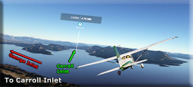
Ahead there is a "Y" water intersection. The George Inlet goes to port, the Carroll Inlet heads to starboard. Fly into the Carroll Inlet. We will be following this to almost the end of the inlet with a couple of course adjustments along the way.
- Carroll Inlet is a bay located just 15.9 miles from Ketchikan, in Ketchikan Gateway Borough, in the state of Alaska, United States, near Beaver Falls, AK. Whether you’re fly fishing, spinning or trolling your chances of getting a bite here are good. So grab your favorite fly fishing rod and reel, and head out to Carroll Inlet. Alternate names for this bay include Carrol Channel, Carroll Channel and Carol Channel.
- Join us as we discuss the Alaska Fishing License options, fishing rules and fishing regulations. Please remember to check with the local Fish and Wildlife department to ensure the stream is open to the public. Now get out there and fish! Check out our Fishing Times chart to determine when the fish will be most active.
Leg #04: To "HUME" (Hume Island)
Heading: 016*
Distance: 4.8 nm
Altitude: 1800'
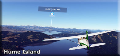
A slight course correction to port will takes us over Hume Island, in the middle of the Carroll Inlet about 5 miles ahead.
Leg #05: To "ISLPT" (Island Point)
Heading: 357*
Distance: 3.7 nm
Altitude: 1800'
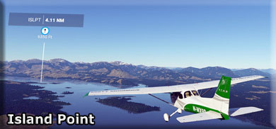
We still follow the Carroll Inlet now looking for Island Point, a tiny peninsula that juts out from the port shoreline. The larger island toward the center of the Inlet is Osten Island.
Leg #06: To "CARX" (End of Carroll Inlet)
Heading: 328*
Distance: 9.5 nm
Altitude: 1800'
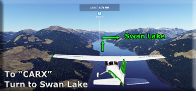
The CARX WayPoint is near the end of the Carroll Inlet (where it becomes Carrol Creek). We will turn sharply to starboard to fly over Swan Lake that becomes viable just before you make the turn. watch for a gap in the hills to starboard, follow it.
Leg #07: To "SWAN" (Swan Lake)
Heading: 062X*
Distance: 2.8 nm
Altitude: 2000
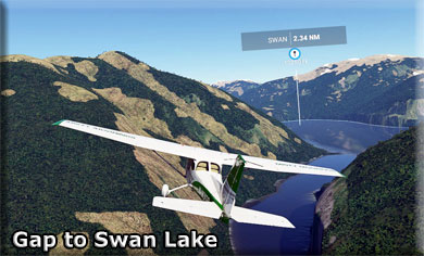
As you approach Swan Lake, you should increase your altitude to about 2000 feet to go over some up-coming peaks in the terrain.
Leg #08: To "SWANX" (End of Swan Lake)
Heading: 020*
Distance: 2.1 nm
Altitude: 1800'
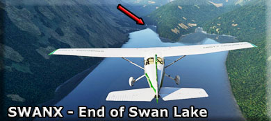
Fly to the end of Swan Lake and ease to the port shoreline. You will be looking for Maze 1 WayPoint ahead and a little to starboard.
Leg #09: To "MAZE1" (Maze 1)
Heading: 037*
Distance: 4.0nm
Altitude: 1800'
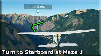
You will be following a valley slowly curing to starboard. Make a turn to starboard at Maze 1 and continue to follow the valley to Maze 2.
Leg #10: To "MAZE2" (Maze 2)
Heading: 070*
Distance: 1.2 nm
Altitude: 2400'
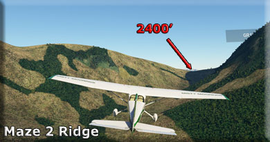
INCREASE your altitude to 2400 feet to pass over a ridge at Maze 2 before you drop back down to 1800 feet to fly over Grace Lake.
Leg #11 To "GRACE" (Grace Lake)
Heading:120*
Distance: 2.3 nm
Altitude: 1800'
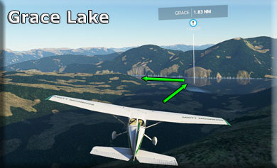
Now you can drop your altitude back down to 1800' and glide casually over beautiful Grace Lake. About the center of the lake you will turn about 90 degrees to port to follow the lake to its end at GRACX.
Leg #12: To "GRACX" (Grace Lake End)
Heading: 047*
Distance: 2.4 nm
Altitude: 1800'
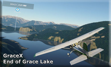
You fly to the end of Grace Lake and as you cross over the far shoreline, you'll see the beautiful Behm Canal ahead. We will be crossing the Behm to Walker Cove on the other side.
Leg #13: To "BEHM" (Behm Canal)
Heading: 024*
Distance: 3.1 nm
Altitude: 1800'
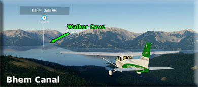
The Behm Canal is about 2 miles wide at this point. We will fly over it to Walker's Cove on the other side.
- Behm Canal is a natural channel in the Alexander Archipelago, in the southeastern part of the U.S. state of Alaska.
- About 108 miles (174 km) long, Behm Canal separates Revillagigedo Island from the mainland. From the Clarence Strait, Behm Canal extends north and northeast, through the Behm Narrows and by the mouth of the Unuk River, then south to Revillagigedo Channel..
- The Behm Canal was charted and named by George Vancouver in 1793, in honor of Magnus Von Behm, who was the governor of Kamchatka in 1779 when Captain James Cook's ships, with Vancouver among the crew, arrived at Petropavlovsk shortly after Cook was killed in Hawaii. It was Behm who carried the news of Cook's death to Europe.
- The canal is used by the Southeast Alaska Acoustic Measurement Facility (SEAFAC) as an acoustic testing site for United States Navy submarines.
- New Eddystone Rock is a craggy, much-photographed basalt island in Behm Canal.
We continue to fly up the Behm to arrive at the Chickamin River Outfall.
Leg #14: To "CHIC" (Chickamin River Outfall)
Heading: 3295*
Distance: 6.6 nm
Altitude: 1800'
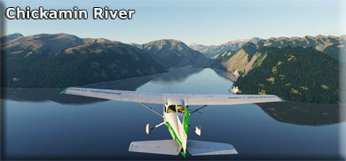
The Chickamin River is the outfall from many rivers that are coming from the glacier area of the park. We will follow the Chickamin up to the Leduc River that comes in from Port. Keep following the river to "LEDUC" The Chickamin River undulates left and right ... just follow the easy curves and enjoy the incredible view.
Leg #15: To "LEDUC" (LEDUC RIVER TURN)
Heading: 020*
Distance: 9.3 nm
Altitude: 1800'
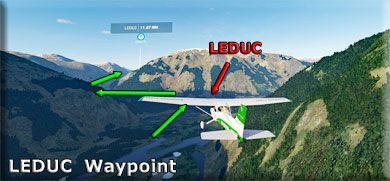
We will follow the Chickamin River Basin to the Leduc River Turn at "LEDUC". Here you will turn to port, then shortly turn back to starboard following the Leduc River Basin, nearly all the way to the glacier.
Leg #16: To "LEDU2" (Leduc2 WayPoint)
Heading:358*
Distance: 10.3 nm
Altitude: 1800'
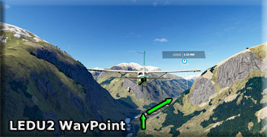
Continue to follow the Leduc river basin. It curves back and forth, but is easy to follow as you head for LEDU2 WayPoint. As you approach the WayPoint, the basin turns slightly to starboard, be sure to watch for that turn (do not turn to port).
Leg #17: To "GTURN" (Glacier Turn WayPoint)
Heading: 043*
Distance: 3.6 nm
Altitude: Begin increase to 7000'
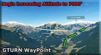
As you approach "GTURN", begin increasing your altitude, you will need to be at 7000' in about 8 miles!
- (Hint: do maximum climb until you are at 7000' the final slope is very steep, if you are not at altitude, you will not be successful.)
Leg #18: To "GLACV" (Glacier View)
Heading: 075*
Distance: 3.9 nm
Altitude: Continue increasing to 7000'
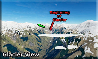
At GLACV, you see the "tail" of the glacier coming down the mountain from the left. You will fly "up" that glacier (turning to port) and hopefully you have been climbing enough to reach "TOP", the next WayPoint. .
Leg #19: To "TOPX" (TOP WayPoint)
Heading: 013*
Distance: 2.3 nm
Altitude: 6000+
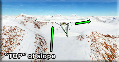
As you reach the end of the very steep slope of the glacier, get ready to turn to starboard, continue climbing, get to 7000'!
Leg #20: To "HUMP" (Glacier Hump)
Heading: 051*
Distance: 2.5nm
Altitude: 7000+
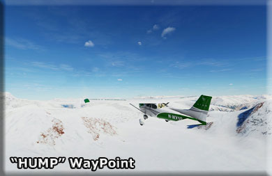
You will encounter a small mountain on the top of the glacier (the hump). You can fly around it to the right and then come back on course if you are altitude deficient (too low).
Leg #21: To "SUMM" (Glacier Summit)
Heading: 051*
Distance: 2.5 nm
Altitude: 7000+
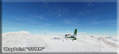
You are now heading for "SUMM" which is on the very top of the glacier. You can level off and enjoy the incredible view. We soon will be going down in altitude, all the way to Stewart. You are flying over the Texas Glacier.
Leg #22: To "GLACX" (Glacier end)
Heading: 051
Distance: 7.2 nm
Altitude: Begin Decreasing Altitude
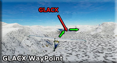
At GLACX, you make a turn to starboard and begin descending to 1200 feet ... gradually. You have about 17 miles to reach 1200 feet, so you can decrease altitude and follow the valley you will find ahead. It takes you all the way down to the Portland Canal, where you will turn to port to approach Stewart CZST.
Leg #23: To "SALG" (Salmon Glacier)
Heading: 156*
Distance: 9.4 nm
Altitude: Continue decreasing altitude to 1200'
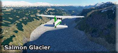
Continue decreasing altitude,ahead, you will see the glacier turns into a river ... this is the Salmon River that you will follow all the way to the Portland Canal.
Leg #24: To "SAL" (Salmon River)
Heading: 162*
Distance: 6.4 nm
Altitude: Continue decreasing altitude to 1200'
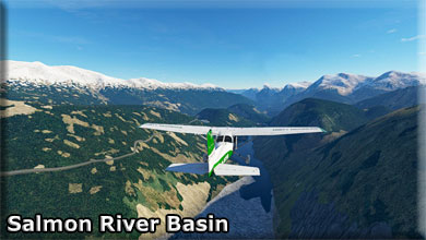
The Glacier becomes the Salmon River. You follow this river and the basin all the way to the Portland canal. You should be at about 1200 feet when you reach the Portland.
Leg #25: To "PORT" (Portland Canal)
Heading: 146*
Distance: 6.2 nm
Altitude: 1200'
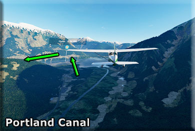
You continue to descend following the Salmon River basin down to the Portland canal. You will fly over the Community of Hyder and take a sharp turn to port following the canal to CZST just a couple miles ahead.
- The Nisga'a, who lived around the Nass River, called the head of Portland Canal "Skam-A-Kounst," meaning safe place, probably because it served them as a retreat from the harassment of the Haidas on the coast. They traveled in the area seasonally to pick berries.
- The area around the Portland Canal was explored in 1896 by Captain D.D. Gaillard of the U.S. Army Corps of Engineers.
- In 1898, gold and silver lodes were discovered in the region, mainly on the Canadian side, in the upper Salmon River basin. The Stewart brothers, for whom the British Columbia town was named, arrived in 1902.
- Hyder was established in 1907 as "Portland City", after the canal. In 1914, when the US Post Office Department told residents that there were many U.S. communities named Portland, it was renamed Hyder, after Frederick Hyder, a Canadian mining engineer who envisioned a bright future for the area. Hyder was the only practical point of access to the silver mines in Canada; the community became the port, supply point, and post office for miners by 1917. Hyder's boom years were the 1920s, when the Riverside Mine on the U.S. side extracted gold, silver, copper, lead, zinc, and tungsten. The mine operated from 1924 to 1950.
- In 1928, the Hyder business district was consumed by fire. By 1956 all significant mining had ceased, except for the Granduc Mine on the Canadian side, which operated until 1984 and 2010 to present. Westmin Resources Ltd operated a gold and silver mine on the Canadian side in Premier, British Columbia but is not currently active
Leg #28: To "CZST" (Stewart BC Airport)
Heading: 156*
Distance: 9.4 nm
Altitude: Landing and Approach
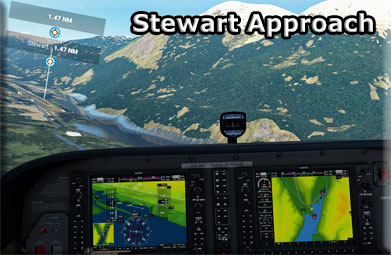
Leaving WayPoint PORT, you will fly over the small community of Hyder, heading sharply to port to land at Stewart (CZST).
- The Nisga'a, who lived around the Nass River, called the head of Portland Canal Skam-A-Kounst, meaning "safe house" or "strong house", probably because it served them as a retreat from the harassment of the Haida and Tlingit from the outer coast. They travelled in the area seasonally to pick berries and hunt birds. It and the rest of the Portland Canal had been the domain of the Tsetsaut people, also called the Skam-a-Kounst Indians, or Jits'aawit in Nisga'a, an Athapaskan people who became decimated by war and disease and were driven out of the Stewart area by either Haida or Nisga'a in 1856–57.
- The Portland Canal was first explored and named in July 1793 by Captain George Vancouver in honour of William Henry Cavendish Bentinck, 3rd Duke of Portland (1738–1808), Home Secretary from 1794 to 1801. Vancouver met two friendly native people at the current site of Stewart, BC.[4] The area around the Portland Canal was again explored in 1896 by Captain D.D. Gaillard of the United States Army Corps of Engineers (after whom the Gaillard Cut in the Panama Canal was later named). Two years after Gaillard's visit, the first prospectors and settlers arrived. Among them was D. J. Raine, for whom a creek and a mountain in the area are named. The Stewart brothers arrived in 1902. In 1905, Robert M. Stewart, the first postmaster, named the town Stewart.
- Gold and silver mining dominated the early economy. Nearby Hyder, Alaska, boomed with the discovery of rich silver veins in the upper Salmon River basin in 1917 and 1918. Hyder became an access and supply point for the mines, while Stewart served as the port for Canadian mining activity, which was centered on the town of Premier, which was accessed by a 14 miles (23 km) road from Hyder. Other mines in the area were the Jumbo, BC Silver, Red Cliff, and Porter-Idaho. More large camps were south of Stewart at Anyox and Maple Bay.
- Stewart had a population of about 10,000[citation needed] prior to World War I, which then declined to about 700 in 2000. As of 2005, its population had reduced to less than 500.
- Disney's Eight Below, starring Paul Walker and Jason Biggs, was partially filmed here. The exterior shots from John Carpenter's science fiction classic The Thing were filmed within Salmon Glacier.
We Hope you enjoyed the trip!

|
