
| VFR 1200' - Mirror Lake Fishing Trip |
| Dispatch #MS004 |
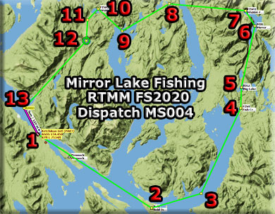
Map
Flight Plan
Dispatch Setup
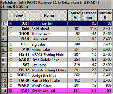
NOTAM: When you are "down" the dispatch and need to see the map, click on the Leg #xx Link and it will open the map, click your "back' button for it to disappear. NOTAM: This flight can be flown with any (small) wheeled aircraft. It works best with an amphibian so you can actually land on the water. (The Little Bird L-19 is a great choice). If you do not have an amphibian, just fly low over the fishing spots to see them, then continue on to the next WayPoint. Dispatch Overview You are flying a commercial ferrying service for a local outfitter taking people out to various fishing lakes for a day of fishing in your (secret) fishing spots. You have one passenger who wants to fish at Mirror Lake (a buddy told him it was best). But you, knowing a better spot, have a backup fishing hole at the little cove at Leask Lake. (A good fishing guide always has a backup plan!) Leg #01: Starting at PAKT - Ketchikan
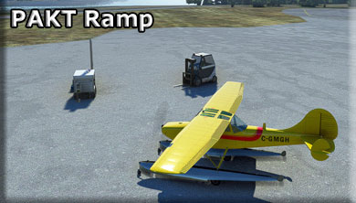
Your customer comes across the Tongass Narrows from Ketchikan on the ferry. You meet him at the dock and escort him to your plane at the PAKT Ramp. Leg #02: To "BOLD" (Bold Island)
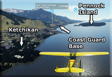
When we take off, we head out over the Tongass Narrows and head roughly east. We will cross over Pennock Island in the center of the narrows. Pennock reef extends to a length of 0.7 miles (1.1 km) into the Tongass Narrows and is 0.7 miles (1.1 km) to the south west of Ketchikan, opposite its downtown. The village of Pennock is located near Whiskey Cove, across from the Coast Guard Station Ketchikan. A few houses are tucked within the thick wooded forest; there is minimal human habitation.
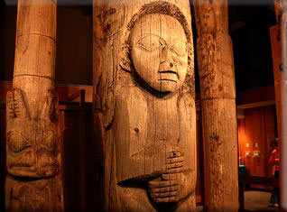
As we cross Pennock Island, look for the Totem Heritage Park not far inland from the Coast Guard Station. The Totem Heritage Center has the largest collection of unrestored 19th century totem poles, but that's just the beginning of what it has to offer! Also displayed are baskets, masks, regalia, carvings, and my personal favorite, the incredible photographs of the old villages where the poles were retrieved. Not to mention the many carvings and totem poles outside the building! This is one of the Ketchikan Alaska Attractions not to be missed!
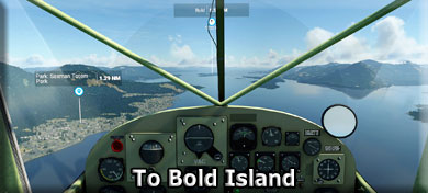
The little community of Saxman is to port, there is another Totem Pole park there also. And if you are REALLY into totem poles ... there is ANOTHER one at the Totem Bight Park that is in western Ketchikan. We will pass near it on the return flight. We are heading for BOLD island, located in the Revillagigedo Channel between Annette and Revillagigedo Island. It is about 3 miles long. This is one of the key WayPoints for the area for approaching and leaving Ketchikan to the east. Over Bold Island, you turn to port into the large waterway which is the Thorne Arm. Leg #03: To "THOR" (Thorne Arm)
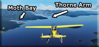
As we enter the Thorne Arm, there is a beautiful little bay to port named Moth Bay, another excellent fishing spot. Thorne Arm is a bay located just 16 miles from Ketchikan, in Ketchikan Gateway Borough, in the state of Alaska, United States, near Beaver Falls, AK. Whether you’re trolling, fly fishing or spinning your chances of getting a bite here are good. You suggest this as an alternate fishing site for a future trip. Thorne Arm was named in 1880 by U.S. Coast and Geodetic Survey (USC&GS) for Captain Charles Thorne, commander of the steamer California which explored this area. Leg #04: To "FISH" (Fish Creek)
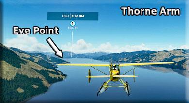
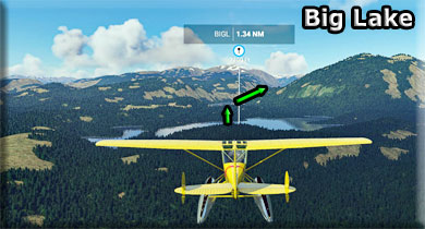
We follow the Thorne Arm, we pass Eve point of the port side. Then following the arm to its end heading, WayPoint FISH that highlights Fish Creek. We will fly over Fish Creek. Leg #05: To "BIGL" (Big Lake)
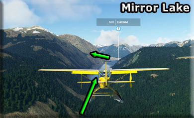
The BIGL (Big Lake) WayPoint lines you up for your approach to Mirror Lake. Stay at 1200' altitude but no lower in this area. Ahead you will see a valley that turns a little to starboard. Follow that valley to Mirror Lake. Leg #06: To "MIR" (Mirror Lake)
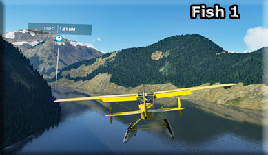
Mirror Lake is very narrow. You should be in approach mode as you near the end of the lake. The lake bends to port and you will be making a turn there looking for FISH1 Leg #07: To "FISH1" (Fish One!)
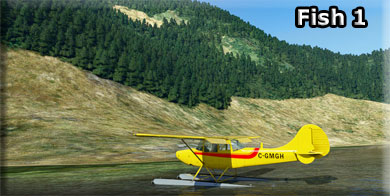
Taxi to a grassy point on the starboard shore. The fly fishing has been excellent in the shallows here. If you are in an amphibian, land and stop at the point for some relaxing and fishing. (If not amphibian, do a low pass and continue on to the next WayPoint.)
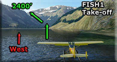
Since the fishing was not so good at this location today, your "backup plan" for your customer was a good idea. You set up to take off for Leask Lake, and a little cove you know there that will always hold a memory for a customer! Taking off from FISH1, Point your aircraft due west. You will see a gap in the mountains in that direction. Climb steeply toward 2400'. As you enter the gap, turn to port and continue your climb toward FISH2.
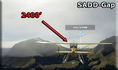
Leg #08: To "SADD" (Little Saddle Lake) You must climb quickly coming up from FISH1 on Mirror Lake. You head for the gap in the mountains to the west and fly over a ridge there needing 2400' altitude.
After clearing the SADD gap, you and ease up on the throttle and drift back down to 1200' altitude. Ahead, you will cross the Carroll Inlet. Little Saddle Lake (SADD) and Big Saddle Lake are the next WayPoint. Leg #09: To "BAT" (Bat Point)
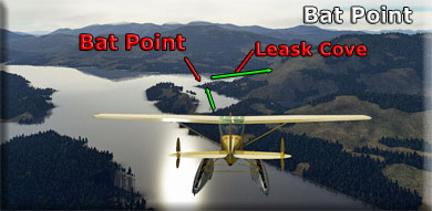
Bat Point is located at the western end of the George Inlet. As you fly over it, you are heading for a little bay named Leask Cove, (this is still salt water). Then you set a course for Leask Lake generally following Leask Creek.
Leg #10: To "FISH2" (Leask Lake Fishing Hole)
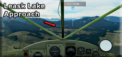
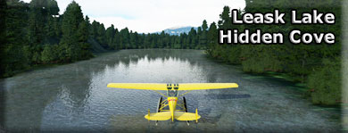
As you turn over Leask Cove and see the shallow valley made by Leask Creek, you follow it to Leask Lake and one of my favorite fishing holes, FISH2. You approach and land on the lake staying near the starboard shore. Once safely on the water, go to the western side of the lake and you will find a tiny cove. The fishing is best back in that little, and very scenic cove. The water is very shallow, about 2-3' deep.
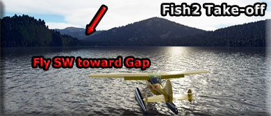
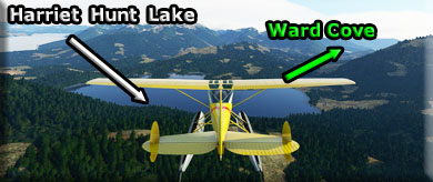
Point your aircraft to SW after leaving cove, take off toward the gap and turn a little to port to line up on Harriet Lake. Leg #12: To "DODGE" (Dodge the Mountain) "Dodge" is a WayPoint that will help you get around a small mountain and line up on Harriet lake. Climb to 2000'. As you pass over Harriet Lake and turn toward Ward cove, you can reduce your altitude to 1200' Leg #13: To "HARR" (Harriet Hunt Lake)
As you cross over the ridge before Harriet Lake, you can begin to reduce your altitude back down to 1200'. Over Harriet Lake, you will be turning to starboard toward Ward's Cove.
Leg #13: To "WARD" (Ward Cove)
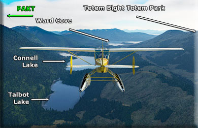
Turn toward Ward Cove and follow the valley there to the cove. You should think about contacting TRAFFIC for PAKT and announce your landing intentions. As you approach Ward Cove, two lakes will pass by to port, the first one is Talbot lake and the second, longer lake is Connell lake. Watch for the remnants of the paper mill as you approach Ward Cove, the buildings are on the starboard shore.
The Totem Bight Totem State Park is to starboard as you cross over Ward Cove. Leg #14: To "PAKT" (Ketchikan Airport)
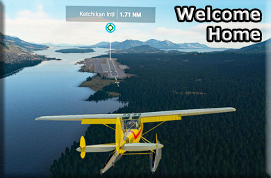
As you leave Ward Cove, turn to port into the Tongass Narrows to line up on the runway at PAKT. Please join us for another fishing expedition soon. We hope you enjoyed this trip.
|