
| Return to Misty Moorings - Trip Tic V-3 |
Destination: The Last Resort at Bear Island Route Notes
Trip Ticket Overview FROM: Wasilla (PAWS)
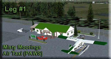
Setup Optional Misty Moorings Air Taxi Starting Point: Latitude: N61 34.29 Leg: From Wasilla (PAWS) to Jonesville Mine (JVS) Comments: It is optional for you to start off at the Misty Moorings Air Taxi Service Building at PAWS. If you have installed that scenery, use the lat/long information in the Setup to place yourself at this building at PAWS. Otherwise start anywhere at the airport. You can easily maintain a 1200 foot altitude. The area you will be flying over is relatively flat. On your way, you will see several small "residential" airstrips and some smaller airports. It seems everybody in this area flies their own plane. (The reason for the Misty Moorings Air Taxi service is for people to explore the many places to land in this area. Narration: We are flying to the Jonesville Mine. this is an historic site in Alask and has a lot of history. And it isn't a "gold mine" ... it's a "cola mine!" The Evans Jones Coal Mine operated between 1920 and 1968 in Sutton, AK where it produced over five million tons of coal and was the site of a serious mining accident in 1937. Much of the mine (now known as the Jonesville Mine) is currently under various stages of active reclamation under the Abandoned Mine Reclamation Act, largely as a result of coal fires in the area. There are still a number of active fires at the site, mostly in the tailings waste left by previous operations.
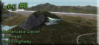
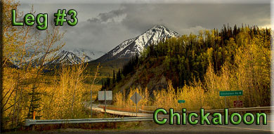
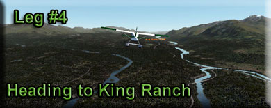
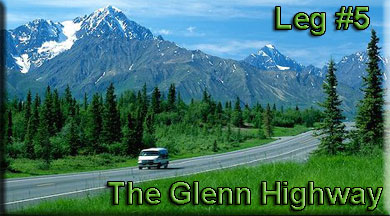
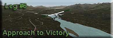
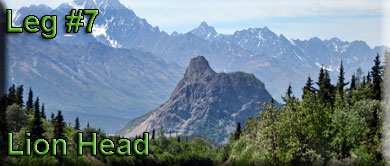
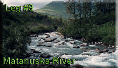
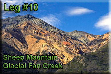
NOTAM: Watch out for the ridge to port (Whishbone Hill) as you approach Jonesville Mine. If you are at 1800 feet, it is higher than your altitude. The GPS track flies you past it safely, but if you are not using GPS, be careful! Wishbone Hill is the beginning of the Anthracite Range we will be following. Leg: From Jonesville Mine to Carpenter Creek Comments: We continue to fly up the Matanuska Valley following the river. You will see several creeks coming from the mountains to port, all are draining toward the river. Maintain 2000 feet and continue to Carpenter Creek. Narration: Matanuska-Susitna Valley (known locally as the Mat-Su or The Valley) is an area in Southcentral Alaska south of the Alaska Range about 35 miles (56 km) north of Anchorage, Alaska. It is known for the world record sized cabbages and other vegetables displayed annually in Palmer at the Alaska State Fair. It includes the valleys of the Matanuska, Knik, and Susitna Rivers. 11,000 of Mat-Su Valley residents commute to Anchorage for work. It is the fastest growing region in Alaska and includes the towns of Palmer, Wasilla, Big Lake, Houston, Willow and Talkeetna. The valleys are shaped by three mountain ranges: the Alaska Range, the Talkeetna Mountains and the Chugach Mountains. The Matanuska-Susitna Valley was carved by glaciers leaving thousands of lakes. The Mat-Su rivers and lakes are home to the spanning grounds of chinook, coho, sockeye, pink, and chum salmon. The area is home to 31 state parks and campgrounds. The 23,000-square-mile (60,000 km2) Matanuska-Susitna Borough (the Alaskan equivalent of a county) governs the Mat-Su Valley. According to the 2010 Census, the borough's population is 88,995, a 50% increase since 2000. The Mat-Su Valley was originally inhabited by Athabaskan Indians and was explored by Russians in 1818. In 1935, as part of the New Deal 200 families from the Midwest traveled to Alaska and started the Matanuska Valley Colony. Palmer was originally inhabited by Athabaskan Indians. In 1880 a trading station was built and the area was settled by gold miners in 1913. Wasilla was originally inhabited by the Dena'ina Indians. The city began when the Alaska Railroad was constructed in 1917. In 1915, Knik was settled by trappers and miners. Talkeetna began in the 1890s, with the construction of a trading station and later the Alaska Railroad. Today, Talkeetna serves as the starting point for mountaineers who climb Mount McKinley. Leg: From Carpenter Creek to Graham (48AK) Comments: We will be maintaining our course up the Matanuska River Valley. Ahead is the Chickaloon area that has an interesting history. Narration: Chickaloon Native Village, Nay’dini’aa Na’, our name in Ahtna, meaning “the river with the two logs across it”, is a vibrant, innovative, and culturally rich Ahtna Athabascan Tribe located in Sutton, one of the most picturesque communities in Southcentral Alaska, about a 90-minute drive from Anchorage, along the Glenn Highway, Scenic Byway. Surrounded by snow-capped mountains, glaciers, and lush boreal forests our Tribe has occupied this area for the past 10,000 years. However, threats our culture, language, and traditional way of life have been unwavering for the past hundred years. Chickaloon Native Village was one of the first Tribes to be affected by outside development. Dating as far back as 1900, Chickaloon Village’s traditional territories have been subjected to large scale resource extraction including coal, copper and gold mining, oil and gas drilling, and logging. The Glenn highway and railroad construction also impacted Chickaloon’s Tribal lands negatively. Alcohol and diseases such as polio, tuberculosis, and the Spanish flu, brought in with development, almost wiped out our Tribe. During the 1930s through the 1950s, the United States government established and enforced a mandatory educational system intended to assimilate Alaska Natives. Many of the Tribe’s children were taken from their families and placed in boarding schools throughout the state. Because of this, the Tribe experienced negative socialization, abuse, neglect and years of separation from their families. The boarding school experience created a generation of people (now Elders) deprived of their cultural traditions leaving them with a legacy of internalized oppression and shame. As a response to the environmental and social injustice suffered by Chickaloon Village Tribal citizens, coupled with the passing of the Alaska Native Claims and Settlement Act (ANCSA) of 1971, our Elders re-established the Chickaloon Village Traditional Council (CVTC) in 1973, to reassert the Tribe’s identity, cultural traditions, economic self-sufficiency and to reunify our citizens. The mandate for the Council was: To restore our traditional worldview by rejuvenating our traditional Athabascan culture, values, oral traditions, spirituality, language, songs, and dance. Chickaloon Native Village gained federal recognition in 1973 and on November 24, 1982, according to Federal Register Vol. 58, No. 202. We are governed by a nine-member Traditional Council (CVTC), tasked to reassert the Tribes identity and cultural traditions, and create economic self-sufficiency for the Tribe. Leg: From Graham to King Ranch (AK59) Comments: Continue on the new heading of 066* for four miles to get to King Ranch, ahead near the river. Narration: The name "Athabascan" comes from the large lake in Canada called "Lake Athabasca". The lake was given its name by the Cree Indians, who lived east of it. In Cree, "Athabasca" means "grass here and there", and was a descriptive name for the lake. The name was extended to refer to those Indian groups which lived west of the lake. It also refers to the large language family of which all the languages of Athabascan Indians are a part. There are eleven different Athabascan languages in Alaska, many others in Canada, some in California and Oregon, and the Navajo and Apache languages in the Southwestern United States. The Athabascan people call themselves ‘Dena,’ or ‘the people.’ Athabascan Regional Bands: Within each of the eleven Alaskan Athabascan language groups there are local dialects, and in the past each dialect corresponded with a social and geographical unit called a "regional band," made up of from 30 to 100 nuclear families. (A nuclear family is a unit consisting of parents and their still dependant children.) The eleven language groups themselves were not political units, and Athabascans did not recognize membership in any group larger than the regional band (dialect group). For example, although the language of several regional bands was Ingalik, members of those regional bands did not consider themselves part of a large group called "Ingalik". The eleven language groups are externally observed groups, not groups in the minds of the Athabascans themselves. Group formation was dependent on the number of people who could most efficiently utilize the resources available. Since different resources required different numbers of people, a person belonged to several different social groupings in any one year. For instance, summer fish camp often brought an entire regional band together. There were enough fish for all, and often the site for fish camp was the part of the local river system which was most abundant in fish. The entire regional band might also join together for fall caribou hunts, when the cooperation of all members was necessary to repair and man the caribou fence. Leg: From King Ranch to Winding Creek Comments: We continue to follow the Matanuska river valley and you will notice a highway beneath us most of the way. This is the famous Glenn Highway. The highway climbs a ridge to port. Be sure to stay near to over the river and and increase your altitude to 3000 feet. We are gradually moving higher into the interior. Narration: The Glenn Highway - Most of this journey follows the Glenn Highway. This is a 135 mile stretch of road that takes travelers north of Anchorage and along historic pathways and natural wonders of Alaska. Imagine having the chance to discover a place created in the wake of a slowly receding wall of ice and snow. Well, this byway tells the true story of Alaska and provides a picture of Alaska's past, present and future. from the urban vibe of Anchorage to the majestic Talkeetna Mountains and everything in between, this ever-changing panorama of wild beauty is an outstanding drive for both visitors and residents. Running parallel to the paths carved by the Manatuska Glacier, the Glenn Highway makes it possible to trace the glaciers that formed this area, and provides some of the most accessible glacier-viewing in the state, as well as amazing geological formations. You can follow the history of Alaska native peoples and tribes, explore the bygone eras of the gold rush and mining industries. You can also visit with tru pioneers that helped shape this land. You will enjoy rushing rivers, crystalline lakes, hiking trails for all skill levels and immense mountain views at every turn, with plenty of modern amenities and places to stop along the way. A journey down the Glenn Highway takes you into all that makes Alaska unique and unforgettable (This from www.glennhighway.org) Leg: From Winding Creek to Victory (0AK6) Comments: Follow the river's bend to port. The Victory Airport is on the port side of the river above on the ridge. Narration: The ridge we are following to port is the Anthracite Ridge. This is one of the best rockhounding locations in Alaska for fossils. The mining of anthracite was important to this area of Alaska. Anthracite comes from Greek: (Greek aνθρακίτης (anthrakítes), "coal-like," from άνθραξ (ánthrax), coal)[1] is a hard, compact variety of mineral coal that has a high luster. It has the highest carbon content, the fewest impurities, and the highest calorific content of all types of coals, which also include bituminous coal and lignite. Anthracite is the most metamorphosed type of coal (but still represents low-grade metamorphism), in which the carbon content is between 92.1% and 98%. The term is applied to those varieties of coal which do not give off tarry or other hydrocarbon vapours when heated below their point of ignition. Anthracite ignites with difficulty and burns with a short, blue, and smokeless flame. Anthracite is categorized into standard grade, which is used mainly in power generation, and high grade (HG) and ultra high grade (UHG), the principal uses of which are in the metallurgy sector. Anthracite accounts for about 1% of global coal reserves, and is mined in only a few countries around the world. Leg: From Victory to Lion Head Comments: Lion Head is an interesting rock formation you will find ahead, it is difficult to miss since it is unique in the formations. We use it as a waypoint. Narration: If you are traveling below on the Glenn Highway, mile 110 showcases the beauty of Lion's Head, best seen as you turn back towards Anchorage. Its Athabascan name is "Tssisyu Ts'akae" and was once an ancient volcano. Lion's Head showcases the beauty and power of the geological forces that helped shaped the magnificence of the Glenn Highway corridor. The Grand View Café and RV Park are here as well, and you can grab a bite to eat at the café before you head back home. This area is known for its white water rafting and there are several outfitters you can contact for some very exciting trips. Comment: Watch for the Matanuska Glacier coming up to starboard. Leg: From Lion Head to Gypsum Creek Comments: The Matanuska Glacier passes to starboard. (This is the Manatuska River's source. Beyond Lion Head, we begin following the Cariboo Creek valley. Notice the Glenn Highway is still with us climbing the ridge to port. This valley is called Jackass Canyon. Narration: The Matanuska Glacier is the largest glacier in Alaska that can be reached by vehicle. It is approximately 26 miles long and 4 miles wide at its terminus. It is classified as a valley glacier; a body of solid ice that flows like a river under its own weight through an existing valley. About 10,000 years ago it began its retreat to its present day location, and it has not seen any significant change in mass for almost two decades. Because the Matanuska Glacier is a weather hole, cold air from the glacier forces warm air upward towards the mountain peaks. This results in sunny skies and more favorable weather than its surrounding areas, making this a perfect destination for the Alaskan traveler. Only two hours north east of Anchorage by way of the Glenn Highway, the Matanuska Glacier can be seen for miles before reaching some of its ideal viewing locations. Be patient and watch for large waysides. These locations provide a safe place to take advantage of its magnificent views. At milepost marker 101, you will find the Matanuska Glacier State Recreation Area that encompasses approximately 229 acres. There is not direct access to the glacier from this recreational area, however; this is a popular location to stop and take advantage of the easy walking trail that parallels the glacier and the Matanuska River. A pavilion provides shelter and a resting spot for those who wish to simply sit and enjoy the view. Travelers wanting to experience the ice up-close should visit Matanuska Glacier Park at milepost marker 102. This privately owned park is the glaciers only access point. An entrance fee is collected at the office which then allows travelers to drive up to and park next to the glacier. Those seeking adventure can continue on foot onto the ice in about fifteen minutes. They then can explore the glacier on their own or choose to take advantage of one of the several local guide companies who have appropriate gear to get to some of the glacier’s most spectacular sites. Leg: From Gypsum Creek to Sheep Mountain (PASP) Comments: Sheep Mountain airport will be a little to port about 2 miles ahead. Narration: Even though we pass the Matanuska Glacier, we are still following the Matanuska River. The Matanuska River is a river, approximately 75 miles (120 km) long, in Southcentral Alaska, United States. It drains a broad valley south of the Alaska Range known as the Matanuska Valley. Its headwaters are at Matanuska Glacier in the northern Chugach Mountains, approximately 100 miles (160 km) northeast of Anchorage. It flows generally west-southwest through the Mat-Su Valley, between the Chugach range to the south and the Talkeetna Mountains to the north. It flows past Chickaloon, Sutton-Alpine Palmer and enters the Knik River before finally entering the Knik Arm of Cook Inlet from the northeast approximately 25 mi (40 km) northeast of Anchorage. It is bridged near the glacier, at Palmer, and on the Hayflats. Most of it is considered a class II float, though the seriousness can be greater at high flows. Its flows can range from 800 cfs in the winter to over 25,000 cfs. It is gauged near Palmer. In addition to the glacier, it is fed from numerous streams draining the Talkeetna and Chugach ranges, including Caribou Creek, Coal Creek, Granite Creek, King River, Moose Creek, Wolverine Creek, and numerous other named and unnamed streams. It generally freezes in the winter, ice depths vary greatly, and open water can be seen all year round. It carries a large amount of sediment; during the summer it is typically thick grey colored, and much clearer in the winter and at low flows. The river is roughly paralleled by the Glenn Highway. The Mat-Su Valley is one of the most settled regions of Alaska and one of the few areas in the state to support agriculture. The river is a popular destination for whitewater rafting. Leg: From Sheep Mountain to Glacial Fan Creek, Trail Lake Comment: Two quick way points to get us around Sheep Mountain off the port quarter. Glacier is a very short leg, then you will turn towards Trail Lake. Be at 4500 Feet over Trail. Narration: Early Jurassic greenstone and minor interbedded sandstone and shale is intruded by numerous mafic dikes and at least one body of unmineralized Jurassic granite. Greenstone has been hydrothermally altered and contains at least 6 separate gypsiferous deposits in altered zones along joints and shear zones. Deposits composed of pods and stringers of gypsum, quartz, alunite, kaolin minerals, pyrite and serpentine minerals. The gypsum-bearing material averages 25 to 30 percent gypsum, with a maximum of 50 percent. In addition also reported from same general area are: (1) small irregular quartz-calcite-epidote veins in greenstone containing chalcopyrite, malachite, azurite and possibly bornite and chalcocite (Berg and Cobb, 1967); (2) disseminated chalcopyrite in greenstone over 5 ft thick zone subparallel to bedding (Martin and Mertie, 1914); (3) trace gold in samples of pyritic greenstone (Berg and Cobb, 1967); and (4) minor anomalous concentrations of copper and gold associated with some of the alteration zones and nearby veins.
The gypsiferous material averages 25 to 30 percent gypsum, with a maximum of 50 percent. The six deposits indicated and inferred reserves contain about 659,000 short tons of gypsum material, of which about 50 tons of this material had been mined (Eckhart, 1953). In addition, about 55 tons of clay was mined for the manufacture of fire brick and boiler lining. Samples of pyritic greenstone assayed trace gold, and nearby veins in alteration zones show concentrations of copper and gold.
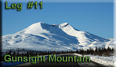
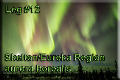
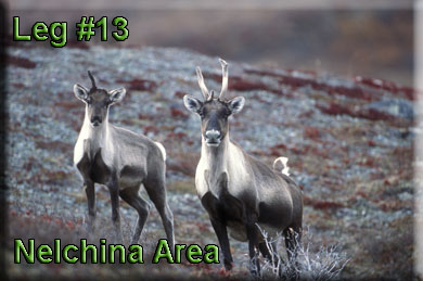
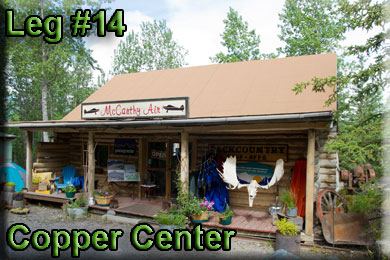
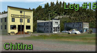
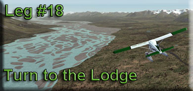
Leg: From Trail to Gunsight Mtn (A88) Comment: Straight Leg. Increase altitude to 4500 Feet. Narration: Gunsight Mountain is a mountain summit in Matanuska-Susitna County in the state of Alaska (AK). Gunsight Mountain climbs to 6,220 feet (1,895.86 meters) above sea level. Gunsight Mountain is located at latitude - longitude coordinates (also called lat - long coordinates or GPS coordinates) of N 61.844167 and W -147.464167. Leg: From Gunsight Mtn to Skelton (PAZK) Comments: A short straight leg. Narration: Oneof the Wonders of living in the northern climes is the aurora borealis as seen in the picture above taken in the Eureke/Skelton area. An aurora (plural: aurorae or auroras; from the Latin word aurora, "sunrise" or the Roman goddess of dawn) is a natural light display in the sky particularly in the high latitude (Arctic and Antarctic) regions, caused by the collision of energetic charged particles with atoms in the high altitude atmosphere (thermosphere). The charged particles originate in the magnetosphere and solar wind and, on Earth, are directed by the Earth's magnetic field into the atmosphere. Most aurorae occur in a band known as the auroral zone, which is typically 3° to 6° in latitudinal extent and at all local times or longitudes. The auroral zone is typically 10° to 20° from the magnetic pole defined by the axis of the Earth's magnetic dipole. During a geomagnetic storm, the auroral zone expands to lower latitudes. Aurorae are classified as diffuse or discrete. The diffuse aurora is a featureless glow in the sky that may not be visible to the naked eye, even on a dark night. It defines the extent of the auroral zone. The discrete aurorae are sharply defined features within the diffuse aurora that vary in brightness from just barely visible to the naked eye, to bright enough to read a newspaper by at night. Discrete aurorae are usually seen in only the night sky, because they are not as bright as the sunlit sky. Aurorae occasionally occur poleward of the auroral zone as diffuse patches or arcs (polar cap arcs), which are generally invisible to the naked eye. In northern latitudes, the effect is known as the aurora borealis (or the northern lights), named after the Roman goddess of dawn, Aurora, and the Greek name for the north wind, Boreas, by Pierre Gassendi in 1621. Auroras seen near the magnetic pole may be high overhead, but from farther away, they illuminate the northern horizon as a greenish glow or sometimes a faint red, as if the Sun were rising from an unusual direction. Discrete aurorae often display magnetic field lines or curtain-like structures, and can change within seconds or glow unchanging for hours, most often in fluorescent green. The aurora borealis most often occurs near the equinoctes. The northern lights have had a number of names throughout history. The Cree call this phenomenon the "Dance of the Spirits". In Medieval Europe, the auroras were commonly believed to be a sign from God. Its southern counterpart, the aurora australis (or the southern lights), has features that are almost identical to the aurora borealis and changes simultaneously with changes in the northern auroral zone. It is visible from high southern latitudes in Antarctica, South America, New Zealand, and Australia. Aurorae occur on other planets. Similar to the Earth's aurora, they are visible close to the planet's magnetic poles. Modern style guides recommend that the names of meteorological phenomena, such as aurora borealis, be uncapitalized. Leg: From Skelton to Nelchina Comments: Narration: Nelchina is an Athabascan Indian name. Gold in the creeks draining from Chugach Mountains brought prospectors to this area in the late 1800s. Nelchina area offered several trails into the mountains. Nelchina was a mining settlement established in 1913. It was first reported by Theodore Chaplin in a 1915 USGS publication. The Nelchina Public Use Area covers about 2.5 million acres in the Talkeetna Mountains of southcentral Alaska. The Public Use Area was established by the legislature in 1985 to protect fish and wildlife habitat, particularly caribou calving areas, trumpeter swan nesting areas, and other important habitats for moose, Dall sheep and brown bear so that traditional public uses of fish and wildlife populations may continue. Also to perpetuate and enhance public enjoyment of fish and wildlife and their habitat including fishing, hunting, trapping, viewing, photography and to perpetuate and enhance general public. The Nelchina Public Use area is the biggest legislatively designated area on state land in Alaska. It is an outstanding area for hunting, fishing, recreation, and mining. The vast area is home for the Nelchina Caribou herd, the third largest caribou herd in Alaska. It also supports important populations of trumpeter swans, moose, Dall sheep, and brown bear. The area has long history of mining, and mining activity continues. Early miners built many of the trails. Today, the trails provide access for mining, hunting, trapping, fishing, hiking, snowmobiling, wildlife, and other recreation year-round. Leg: From Nelchina to Copper Center (Z93) Comments Narration: Copper Center developed where the Valdez Glacier trail reached the Copper River. Andrew Holman was its first resident, establishing a temporary roadhouse near the site in July 1898 to provide shelter for prospectors on their way to the Klondike. He initially erected two tents: one served as Hotel Holman and the other as a makeshift post office. By winter 1899, Holman had replaced his tents with a substantial cabin. Leaving Dick Worthman to run the roadhouse, Holman pioneered the first mail route from Valdez to Eagle. During the height of the Klondike stampede prospectors set up tent camps along both the Copper and Klutina rivers, but the first cabins were built on a site one half mile west of the Copper. Another camp sprang up at what was called Copper Ferry, where a ferry crossed the river. The area got a boost as a goldfield service center in June 1898, when B. F. Millard brushed a trail from there to the mouth of the Slana River via the foothills of Mt. Drum. The east bank site of Old Copper Center apparently was settled in 1901 1902 by prospectors intent on investigating mineral prospects on that side of the river. Its days as a mining center were short lived, but it did draw a Native population and existed for many years as a village. Copper Center rapidly became the primary supply center for prospectors and travelers in the Copper River basin. A telegraph station and the trail's first official post office opened in 1901, with Ringwald Blix serving as the community's first postmaster. The next year, John McCrary staked a homestead about a mile north of the Klutina River crossing. Before long, McCrary opened a hotel as well, the first frame roadhouse between Valdez and Fairbanks. Much of McCrary's property remains in the family's hands. By 1910 American settlers had established over fifty homesteads in the vicinity. The community now received tri-weekly mail delivery in the winter and weekly service in the summer. It also contained the only telegraph station between Valdez and Fairbanks where money could be sent or received by wire. Florence "Ma" Barnes acquired Hotel Holman in 1922, and renamed it the Copper Center Roadhouse and Trading Post. The original building burned in 1932 and was replaced by the southernmost portion of the current one. When Barnes died in 1948, she left her entire estate to a Valdez orphanage. Later that year, it sold George Ashby the property. Although Ashby died in 1979, his family continued to operate the roadhouse. The replacement roadhouse itself burned on May 20, 2012. The family says they intend to rebuild. Leg: From Copper Center to Chitina (CXC) Comments: Maintain 3700 feet altitude. Narration: Athabascans have lived in the area around Chitina for centuries as evidenced by the archaeological sites south and east of Chitina. Before 1900, Chitina was the site of large village whose population was slowly decimated by the influx of people, disease and conflicts. Copper ore was discovered in about 1900 along the northern edge of the Chitina River valley. This brought a rush of prospectors and homesteaders to the area. The Copper River and Northwestern Railway enabled Chitina to develop into a thriving community by 1914. It had a general store, a clothing store, a meat market, stables, a tinsmith, five hotels, several rooming houses, a pool hall, bars, restaurants, dance halls and a movie theater. The mines closed in 1938 and the remaining support activities moved to what is now the Glennallen area. Chitina became a virtual ghost town. Otto Adrian Nelson, a surveying engineer for the Kennecott Mines, eventually bought up much of the town. He built a unique hydroelectric system that supplied electric power to all his buildings. He also supplied much of the town center with hot and cold running water. Current activity in Chitina revolves around the dipnet fishing for salmon that occurs every summer. Alaskans are allowed to dip a large number of salmon during their spawning runs and Chitina is an accessible and popular place for this activity. In late 1977, jeweler Art Koeninger purchased the "Chitina Tin Shop” with the intention of turning it into a residence. In 1979, the site, formerly known as “Fred’s Place” and “Schaupp’s,” was placed on the National Register of Historic Places and has won two historic preservation grants. It currently houses the Spirit Mountain Artworks. Below us is the Copper River. The Copper River rises out of the Copper Glacier, which lies on the northeast side of Mount Wrangell, in the Wrangell Mountains, within Wrangell-Saint Elias National Park. It begins by flowing almost due north in a valley that lies on the east side of Mount Sanford, and then turns west, forming the northwest edge of the Wrangell Mountains and separating them from the Mentasta Mountains to the northeast. It continues to turn southeast, through a wide marshy plain to Chitina, where it is joined from the southeast by the Chitina River (Ahtna Athabascan Tsedi Na’. The Copper River is 287 miles (462 km) long. It drops an average of about 12 feet per mile (2.3 m/km), and drains a total of 24,000 square miles (62,000 km2)—an area the size of West Virginia. The river has 13 major tributaries and runs at an average of 7 miles per hour (11 km/h). It is a mile (1.6 km) wide at the Copper River Delta, near Cordova. Downstream from its confluence with the Chitina it flows southwest, passing through a narrow glacier-lined gap in the Chugach Mountains east of Cordova Peak. There is an extensive area of sand dunes between the Copper and Bremner Rivers. Both Miles Glacier and Child's Glacier calve directly into the river. The Copper enters the Gulf of Alaska approximately 50 miles (80 km) southeast of Cordova. The name of the river comes for the abundant copper deposits along the upper river that were used by Alaska Native population and then later by settlers from the Russian Empire and the United States. Extraction of the copper resources was rendered difficult by navigation difficulties at the river's mouth. The construction of the Copper River and Northwestern Railway from Cordova through the upper river valley in 1908-11 allowed widespread extraction of the mineral resources, in particular from the Kennecott Mine, discovered in 1898. The mine was abandoned in 1938 and is now a ghost town tourist attraction. A road runs from Cordova to the lower Copper River near Child's Glacier, following the old railroad route and ending at the reconstructed "Million Dollar Bridge" across the river. The Tok Cut-Off follows the Copper River Valley on the north side of the Chugach Mountains. The river's famous salmon runs arise from the use of the river watershed by over 2 million salmon each year for spawning. The extensive runs result in many unique varieties. The river's commercial salmon season is short: chinook (king) salmon are available mid-May to mid-June, sockeye (red) salmon mid-May to mid-August, and coho (silver) salmon mid-August to late-September. Sport, personal use and subsistence fisheries are open for salmon from mid-May through October. The fisheries are co-managed by the Alaska Department of Fish and Game and the USDA Forest Service Federal Subsistence Board. Management data are obtained primarily by ADF&G at the Miles Lake Sonar Station and the Native Village of Eyak at the Baird Canyon/ Canyon Creek research stations. The Copper River Delta, which extends for 700,000 acres (2,800 km2) is the considered the largest contiguous wetlands along the Pacific coast of North America. It is used annually by 16 million shorebirds, including the world's entire population of western sandpipers. It is also home to the world's largest population of nesting trumpeter swans and is the only known nesting site for the dusky Canada goose. Over 20,000 years ago, the area now drained by the great Copper River was a massive lake, covering 2,000 square miles (5,200 km2). Leg: From Chitina to Moose Lake Comments: You will want to maintain 3700 feet on this leg. About half way along, you will see Gilahina Butte and Lost Butte. These are both "rises" in your path. Crossing them at 3700 feet gives you about 1200 feet clearance. The River to starboard is the Chitina River. Narration: Presently the river area is used extensively for hunting. There is not much fishing in the Chitina but the ponds and lakes in the area receive heavy use. There is little evidence that the river gets much use as a canoeing stream. The old railroad grade from McCarthy to the Copper River is usable by four-wheel drive vehicles. This road roughly parallels the north bank of the Chitina approximately 3 miles from the river. The State Highway Department is considering grading this roadbed to make it usable for conventional automobile traffic. Leg: From Moose Lake to Jake's Bar (AK0) Comments: Maintain 3700 feet altitude. This will give you an 1800 foot clearance most of the way during this leg. If the weather is clear, look far ahead and you will see the Chitina Glacier ... our destination is at the foot of the glacier. Narration: What you see below you here is the Chitina River Valley System. This entire valley was carved by huge glaciers, that have now retreated after the ice age and are now what we still cal "major" glaciers. The major glaciers of the Chitina River valley system are the Anderson [40 km], Chitina [70 km], Walsh [70 km], and Logan [70 km] Glaciers. All have their accumulation zones in the Icefield Ranges of Canada and flow across the 141st meridian, which defines the border between the Yukon Territory and Alaska. In the recent past, these glaciers were tributaries of a large trunk glacier that occupied the upper Chitina River valley. On the 1975 National Topographic Series (NTS) map sheet 115SW and 115SE (1:500,000 scale), these four glaciers are seen to merge. Now, the Logan-Walsh merger and the Anderson-Chitina merger do not appear to connect with each other. The glacier system also does not appear to merge on two satellite images taken 3 years apart. However, inspection of a later image, the same scene illuminated by a low (13º) Sun angle on thin snow cover shows that a (1- to 1.5-km) section of ice-cored moraine probably still bridges the two glacier pairs. The same pitted surface topography that is characteristic of the terminus of all the glaciers is also seen in that section. The glaciers look essentially the same on the three images, which indicates that they were in a quiescent phase. A surge of Walsh Glacier, thought to have started in late 1960 or early 1961, lasted 4 years and displaced ice as much as 11.5 km—a record for North America (Post, 1966, 1967). Conspicuous medial moraine loops can be traced on the glacier surface, and their spacing can be used to infer a fairly regular surge-cycle periodicity for Walsh Glacier. Note that the Walsh Glacier apparently overrides the end of Logan Glacier (fig. 3). In 1966, the Anderson Glacier showed signs of entering a surge phase (Post, 1967) and was observed to be surging in 1968. It was reported (Field, 1975) that the surge was slowing down in early 1971. Landsat images of 1974, 1977, and 1980 (see fig. 3) show the Chitina Glacier totally overridden by the Anderson Glacier surge. The incredibly "wide" expanse of the land here gives you an idea of the size of the giant glaciers here in the distant past. Comment: Jake's Bar is a small airstrip with runway headings almost on your bearing. Leg: From Jake's Bar to Hunter Creek Comments: Make the final turn and heading and this will line you up on the landing area at Chitina Glacier Lodge. Prepare to go to landing altitude ... your destination is 9.2 miles ahead. Disengage autopilot, lower altitude and fly to the starboard side of Bear Island (ahead in the center of the moraine). As you approach Bear Island, fly to the starboard side of it and stay to the starboard side of the moraine. Watch for boulders that have been placed on the rivers/creeks, these will guide you toward the airstrip. Near the edge of the island, you will find "orange barriers" that have been placed in an "arrow" formation pointing directly at the runway. This runway is narrow and short ... full flaps, good brakes and a lot of care is recommended for a successful landing. Narration: You are now approaching your destination for this flight. There are many things to see and do at "The Last Resort" at Bear Island. There are many side trips you will be able to take from your lodge or your cabin. All facilities have 2 meter radio connection to the Bear Island Lodge Office. Klaus has flown this area for years and is not only a fine pilot, but a well-informed tour guide. A helipad is close by your lodging. If you are located on the water, he may arrive in a float plane to pick you up.
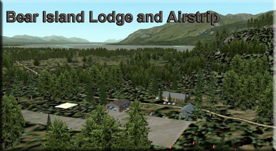
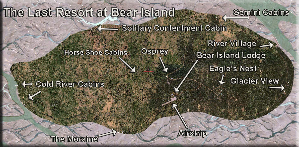
Leg: From Hunter Creek to The Last Resort, Bear Island Comments: As you approach Bear Island (a large island in the middle of the Chitina moraine. Line up on the starboard side of the island. Fly to the starboard side of the moraine. As you approach, watch for boulders in the streams below (they just "happen" to line up exactly with the runway). Your turn will be to port to line up with the runway. Be sure you are at maximum SLOW speed, full flaps. This is a short runway. Narration: The Last Resort at Bear Island is a complex of groups of cabins and lodges. As we arrive at Bear Island, we will be able to see the Cold River cabins to port on the shoreline. Next comes The Knoll lodge (on a small hill). On the moraine "coastline" to starboard you will find The Moraine Lodge. All of the lodges and cabin groupings have helipads and are fully discussed in the "readme" that comes with The Last Resort at Bear Island scenery package.
We hope you enjoyed the flight.
|