
Misty Moorings Air Taxi Check Ride
ROUTE NOTES
- This Scenery is for "Return to Misty Moorings" only.
- Suggested Altitude: 1200 feet
- Landing zone is: dirt, gravel, asphalt
- GPS for destination: Multiple Destinations
- Distance approximately: 150 miles
- Download PRINT-ABLE copy HERE
- Get Flight-Seeing Map and Plan HERE
- Scenery Needed: Misty Moorings Air Taxi

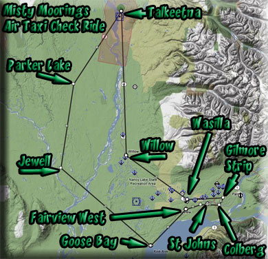
The Misty Moorings Air Taxi
This is a "check ride" to give you the experience of flying an air taxi in the Anchorage area ... landing and taking off often from many of the 137 commercial and community airstrips in the area. This Trip Ticket is intended to get your familiar with this process, giving you some tips along the way as we actually fly a predetermined route.
Check Ride VFR Plan
Leg: Wasilla PAWG to Willow PAUO (Rwy 13/31)
Initial Course:
Leg Distance: 17 miles
The first leg is a short 17 miles. You can go to 1200 feet, but if you wish to fly lower, we won't tell anyone. Set your GPS for Direct to PAWG. (See readme for the air taxi package if you don't know how). Set your gps/nav switch on "gps" ... and once in the air, click on NAV on the autopilot and your plane will turn toward Willow. Establish the altitude you want, or set the autopilot for 1200 and click on "ALT".
You will pass over many small air strips on the way to Willow. Look closely for them, they are difficult to see and you may be landing at one of these later.
As you approach Willow, turn off the AutoPilot and fly toward the airport. The runway headings are 13/31. You are flying a heading of about 290, so as you near the airport, turn a little to port to give yourself some landing room, then when the airport is in site, line up on the runway banking to starboard to make your landing.
Land and turn to port on the first taxiway. You will then turn to port again and follow the yellow line past the hangers on your right. You will find a little terminal about halfway down the taxiway with people walking around.
Leg: Willow PAUO to Talkeetna PATK (Rwy 18/36)
Initial Course:
Leg Distance: 34 Miles
Set your gps for "direct" to PATK (Talkeetna). You can set your altitude at 1200 feet (although there are no obstacles on this leg). The airport is about 33 miles north. Talkeetna is the farthest north of our Misty Mooring Air Taxi service area.
This is a good time to practice a GPS approach. Use your GPS to "select approach" and choose GPS 36 and activate it. The plane will bank to port as it picks up the vectors for coming straight in on runway 36. This will take you right to the runway. You must control the altitude. Most of the small GA airports have the GPS and Approach vectors.
As you approach Talkeetna using the GPS vectors, the aircraft will bank to starboard about 9 miles out, lining up on runway 36.
- (However for most of the small community strips you'll be flying, there are none ... you'll rely on your GPS, a knowledge of the runway heading and your skills to find them nd land safely).
Leg:Talkeetna PATK to Parker Lake 0AK3 (Rwy 14/32)
Initial Course: 216
Leg Distance: 20 miles
Set your GPS for Direct to 0AK3 (the first "letter" is a ZERO) and activate the course. (Be sure your nav/gps switch is set to gps. Set your altitude for about 1200 on the autopilot. Take off, and when safely airborne, activate the altitude and NAV on the autopilot.
Parker Lake is a VERY SHORT runway (something that is more typical of the places you will be landing the Misty Moorings Air Taxi. But it is a wide-open field (unlike the community strips with bbq grills along the edge of the runway!). But you will need to come in at a slow speed. Parker Lake will first show up as a large white square ... but the runway is a dirt strip in the center of it.
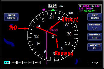
This strip has no GPS vectors to line you up ... and this is more typical of the kind of flying you will be doing. Notice the runway is 14/32 and you are flying at 216. So you when you get about 10 miles from the airport, you'll want to turn off the NAV on the autopilot and steer about 5 degrees to starboard ... moving away from the airport to the right (giving yourself glide slope room). When the airport is showing at 140 degrees on your compass rose, you bank to port to 140 to line up with the airport runway.
Leg: Parker Lake 0AK3 to Jewell AK72 (Rwy 16/34)
Initial Course: 190
Leg Distance: 20 miles
Jewell is only 20 miles away on an initial heading of 190. Set your gps for Direct to AK72 (Jewell). Set altitude for 1200 feet. Make sure your gps/nav switch is on gps. When at altitude, turn on the autopilot.
The Runway for Jewell is 16/34. We are flying at 190. So again, as we approach the airport, turn off the NAV and steer a little to starboard to give yourself some glide slope. When the airport is at 16 on the compass rose (as above), turn to a heading of 160 and that should line you up on the runway.
Leg: Jewell AK72 to Goose Bay Z40 (Rwy 07/25)
Initial Course: 110
Leg Distance: 28
Now we fly to Goose Bay (Z40). Put Z40 into your GPS for a direct flight and activate it. Set your autopilot altimeter at 1200. Make sure the nav/gps switch is on gps. Take off from Jewell and when at a safe altitude, turn on the NAV and ALT on the autopilot ... you are on your way to Goose Bay.
The Runway heading for Goose Bay is 07/25. We are on a course of 110. So when we approach the airport, we'll turn off the NAV and go about 5 degrees to starboard. When the airport shows at 075 on the compass heading, turn to 075 to line up with the runway.
Leg: Goose Bay Z40 to Fairview West AK58 (Rwy 05/23)
Initial Course: 024
Leg Distance: 12 Miles
Now it gets interesting. You should have a fairly good knowledge of your aircraft and have a "feel" for how the area looks. But you've been landing in nice wide-open areas ... fairly easy to locate and fairly easy to land at. Now we are heading for 3 community strips. These more difficult to find (see), they are short, and they are narrow. You would fly to these dropping people off, or dropping off parts for their planes they may be working on in their garages. The flights will be very short, with not much altitude. You won't be using the autopilot. But you will be using the GPS to find the locations ... so here we go to Fairview West AK58.
Enter a DIRECT route to AK58 in your gps. Next, note the runway heading ... 05/23. Look at your route on the gps. Your direct route is about 024. So to land properly on 05, we fly to the LEFT of the airport direct route and watch for the airport to starboard. When we see it and it is about 050 on the compass rose, we turn toward it. Be at a low/flapped/safe speed, ready to land. Here we go. Depart Goose Bay and follow the gps route. Land safely and get ready for the next leg.
Leg: Fairview West AK58 to St Johns Homestead 4AK2 (Rwy 17/35)
Initial Course: 053
Leg Distance: 3 Miles
This is a very short hop. Set your gps for Direct to 4AK2, St. John's Homestead. Note the runway heading and your course. We are going to land on 35, so you must fly to the right of the gps vector and be prepared for a sharp port/left turn to final ... almost 90 degrees. When you take off from Fairview West, stay in landing configuration and stay low ... 700 feet. Watch for the airport off to port and be prepared for the turn to final.
Leg: St John's Homestead 4AK2 to Colberg 5AK6 (Rwy 15/33)
Initial Course: 069
Leg Distance: 4.5 Miles
Colberg is an asphalt runway, a nice little GA airport. We will take off from runway 17 at St John's then make a large U turn to starboard to line up with 33 at Colberg. Set your gps for 5AK6. Look at the gps vector... you are 90 degrees from the vector. Fly away from St. Johns for about 2 miles. Over Wasilla Lake, turn 90 degrees and parallel the gps vector. As the airport shows up about 90 degrees to starboard, turn toward it and land on 33.
Leg: Colberg 5AK6 to Gilmore Strip 39Ak (Rwy 02/20)
Initial Course: 011
Leg Distance: 1.8 miles
We will take off on 17 at Colberg. Our destination is at 7 o'clock behind us. We are going to fly the runway heading for a mile or so, then make a fairly tight turn to port about 180 degrees Parallel the gps track. This is a difficult strip to locate ... so stay at about 700 feet and watch carefully for it.
Leg: Gilmore Strip 39AK to Wasilla PAWS (Rwy 03/21)
Initial Course: 243
Leg Distance: 8.9 Miles
Time to head for home base, back to Wasilla PAWS. On this leg we are going to let the GPS fly the plane to the runway. Set your gps on PAWS and activate it. Set your autopilot altimeter at 1200. Make sure your nav/gps is set to gps. Take off from Gilmore Strip and when at a safe altitude, turn on the NAV and ALT on the autopilot. The plane begins heading direct to Wasilla. Once the autopilot has the aircraft, we set up the gps to vector to the Wasilla Runway 03.
Push the "PROC" button. On "Select Approach" press the "enter" button to the right. It will then say GPS 03 or RNav 03. Select GPS 03. Then it says "Vectors" ... press "enter" to select this. Then you have the choice of "load" or "activate". Select "Activate". The aircraft will fly a pre-arranged gps approach to Wasilla 03. All you have to do is control the altitude. This is a good one to practice for airports that have this feature. When you get used to it, going home is kind of nice ... you set this and pour that last cup of coffee out of the thermos and let the airplane do the work!
Summary:
This has been a "check ride" so you can get a better appreciation of flying an air taxi in a "community" setting. We started off with longer, easier legs to get you used to the aircraft and the gps and autopilot controls. Then we began landing on gravel and dirt strips, sometimes having to navigate to come to the airport on the correct runway heading. I have given you the runway headings in this Trip Tic ... but the way you will use this from now on is by using the MM Air Taxi Airports text file (included in the package). You size the window to make a strip to the right of your FSX window. All of the 137 airports and their runway headings are listed there for your immediate reference. The configuration looks like this:
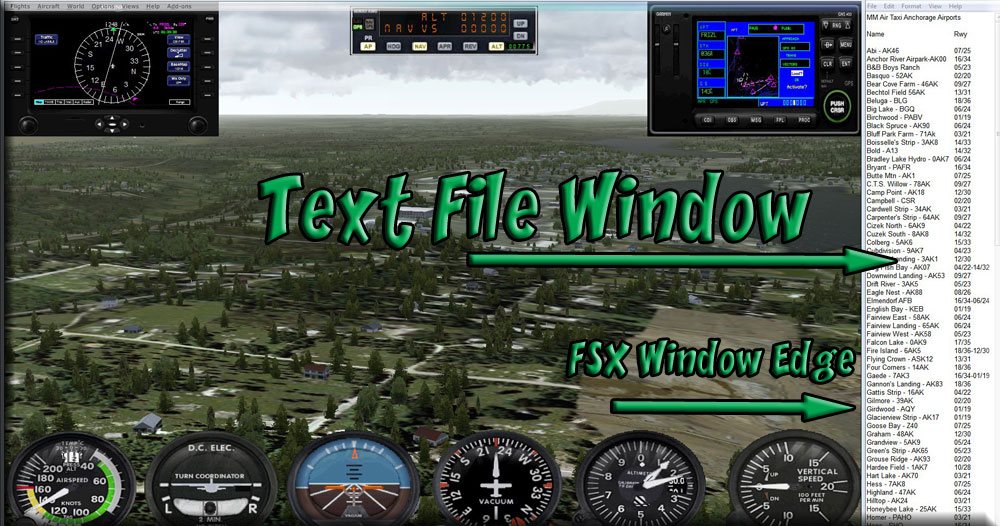
Size the text file window so it shows all of the runway data. Then Size your FSX window to but up against it. When you want the full screen with out the text file, just move the edge of the FSX window to the right to cover the text file. The next time you need it, grab the right edge of the FSX window and pull it left to reveal the text file again.
You have only flown to a very few of the airports and strips. There are 137 of them in the MM Air Taxi Area. Your next step is to use Plan-G and pick your own route, exploring the airports, then using the new skills you've learned here and apply them to exploring the whole area. Weather will play an important role in this package. When the weather is bad, it is still possible to fly, and it can give you some "white knuckle" moments.
Doug Linn
Charter Manager
Misty Moorings, Inc
contact@mistymoorings.com
(March 28, 2013 )