Vancouver - North Island 01
(Added:12.14.2015)
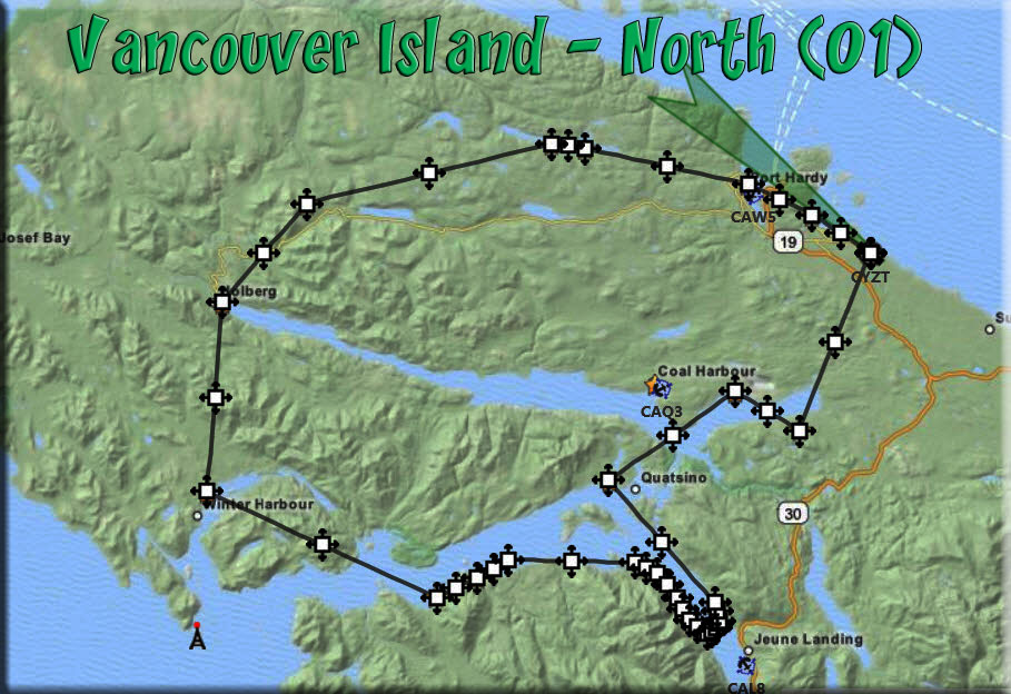
(Click on Map for Larger Image)
Route Notes
- Scenery Needed: ORBX PNW
- Download Flight Plan HERE
- Suggested Altitude: 1200 Feet
- Landing zone is: Water and Land
- Aircraft Type: Amphibian/Helicopter
- Distance approximately: 90 Miles
- Download PRINT-ABLE copy HERE
- Flight-Seeing Flight Map HERE
- Trip Ticket FAQ Usage HERE
- Sceneery Needed: Vancouver North
Route Overview
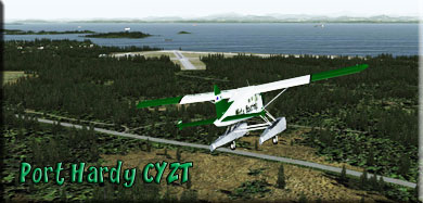
FROM: CYZT Port Hardy
BACK TO:
CYZT Port Hardy
You will be flying in a 90 mile circle. This flight plan will take you to many of the locations added by the Vancouver Island Project - North Island. An amphibian or helicopter is best. Although the plan flies "over" the locations, it is recommended you land at them and enjoy the great scenery that has been added.
Port Hardy Bay From CYZT
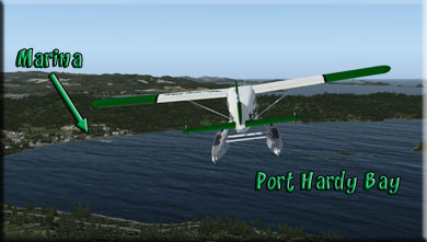
Leg: To Port Hardy Bay from CYZT
Initial Course: 279
Leg Distance: 5.8 Miles
Leg Altitude: 1200 Feet
Information: Fly out of Port Hardy Airport on a heading of 279°. In a short time you will fly over Port Hardy Bay, look for the marina on the far shore.
Port Hardy
from Port Hardy Bay
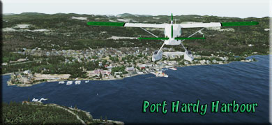
Leg: To Port Hardy from Port Hardy Bay
Initial Course: 262°
Leg Distance: 7 miles
Leg Altitude: 1200
Information: Over the marina, select a course heading of 274° for 3 miles. You will be flying over Port Hardy.
- Located at the northern tip of Vancouver Island, BC, Port Hardy (pop. 4,500) is nestled on the edge of the Queen Charlotte Strait, in the small Hardy Bay. It was the Kwakwaka'wakw First Nations who first settled here some 8,000 years ago, drawn to the region by its shelter from the harsh storms farther north, as well as the rich aquaculture. First Nations culture still abounds in this cozy seaside town. Totems, wood carvings and art galleries throughout town display the talent and legends of native bands still living in the community.
Georgia Lake Hatcheries From Port Hardy
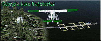
Leg: To Georgia Lake Hatchery 1&2 from Port Hardy
Initial Course: 274°
Leg Distance: 3 miles
Leg Altitude: 1200
Information: As you leave Port Hardy, turn to a course of 274° for about 3 miles. You will come to Georgia Lake. Look for the two fish hatcheries on the port shoreline.
Cape Scott Wind Farm From Georgia Lake
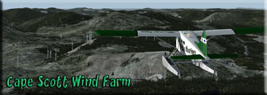
Leg: To Cape Scott Wind Farm from Georgia Lake
Initial Course: 237°
Leg Distance: 10 miles
Leg Altitude: 2800 Feet
Information: Increase your Altitude to 2800 feet. Set a course of 237° and fly to the Cape Scott Wind Farm area. It is a bout 10 miles ahead. There is no place to land in this area, but you may want to circle and see all of the windmills, it is quite an extensive wind farm.'
- On the boggy terrain of the northeast coast of Vancouver Island, British Columbia, the 99 MW Cape Scott Wind Farm proved to be a civil engineering feat for the building team of site developer and operator GDF SUEZ Energy North America. Completed in November 2013, Cape Scott continued the company's commitment to growing its Canadian renewables portfolio and providing sustainable energy to the country's residents
- With a total investment cost of more than $300 million, the project is powered by Vestas V100 1.8 MW turbines and occupies a total footprint of 350 hectares (864 acres) outside of Cape Scott National Park. Having created 300 construction jobs during the peak construction period and having a $51 million economic impact on the area, Cape Scott also created 12 permanent operations and maintenance positions at the facility.
Holberg From Cape Scott Wind Farm
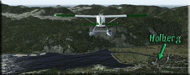
Leg: To Holberg from Cape Scott Wind Farm
Initial Course: 199°
Leg Distance: 5.4 miles
Leg Altitude: 2000 Feet
Information: Over the Wind Farm, turn to a heading of 199° for 5 miles. You will see a body of water just over a ridge, Holberg will be on the starboard shore. There is water to land on at Holberg. It is worth stopping and looking around.
- Holberg (pop. 200) is a community on northern Vancouver Island, British Columbia, Canada. The community was established in the early 1900s by Danish settlers who named their new home in honour of Baron Ludwig Holberg, the great Danish playwright.
- Holberg is on the long, winding, unpaved road to Cape Scott Provincial Park, San Josef Bay and Winter Harbour.Nearby Ronning Gardens, an anomaly in the west coast temperate rainforest, was created by Norwegian settler Bernt Ronning around 1910.
Holberg has always been noted for logging and copious amounts of precipitation.
- During the Cold War, the Royal Canadian Air Force established RCAF Station Holberg, a Pinetree Line radar base.Up on one of the roads of Holberg is a small school called San Josef Elementary. There has never been a large number of children there, but one of the first schoolmarms to have taught there was rumored to have been raised by a pack of wolves.
- Holberg is serviced by an AM radio station, CFHG 1490. CFHG began operations on April 16, 1963 from studios at CFS Holberg. The station primarily aired the programs of Vancouver CBC Radio station CBU, but it also aired local programs produced by volunteer staff at the station. CFHG, which produced up to 28 hours of local programming per week in the beginning, gradually increased its local programming content to as much as 68 hours a week by 1984. When CFS Holberg closed and was mostly dismantled in 1990 due to budget cuts, CFHG was sold to Western Forest Products Ltd. and became a community-owned full rebroadcaster of CBU. Like other CBC Radio One repeaters on Vancouver Island, CFHG now rebroadcasts CBCV-FM Victoria
Winter Harbour from Holberg
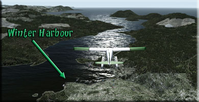
Leg: To Winter Harbour from Holberg
Initial Course: 166°
Leg Distance: 9 miles
Leg Altitude: 2600 feet (to clear ridge)
Information: Leaving Holberg, set a course of 166° for Winter Harbour. You will need about 2600 feet altitude to clear a ridge, then you can drop down quickly to see the little Winter Harbour community. Here again, there are docks on the water where an amphibian or float can land.
- Winter Harbour is a fishing village of 20 people on the northern tip of Vancouver Island, at the mouth of the Quatsino Sound, in British Columbia, Canada. It was named in the 19th century because of its eponymous bay that forms a safe natural harbour.
Mahatta River Logging From Winter Harbour
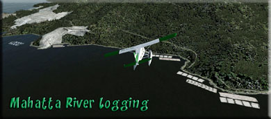
Leg: To Mahatta River Logging from Winter Harbour
Initial Course: 097°
Leg Distance: 11 miles
Leg Altitude: 2400 feet (a ridge)
Information: Leaving Winter Harbour, set a course of 097° for 11 miles to reach the Mahatta River Logging Area. You will find large log floats, and just further upstream the actual logging facility. Once you see the river, you can come down to a lower altitude over the water to view the area better, 1200 feet suggested altitude.
Port Alice Logging From Mahatta River
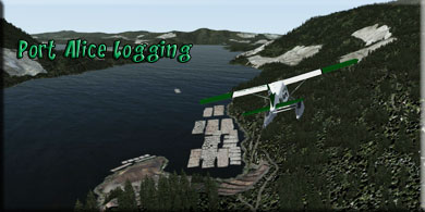
Leg: To Port Alice Logging from Mahatta River
Initial Course: 070°
Leg Distance: 10.2 miles
Leg Altitude: 1200 Feet over the water
Information: Leaving Mahatta River Logging, follow the starboard shoreline for 7 miles, then turn to starboard and follow it another 3 miles. You will see Port Alice Logging on the port shore, make a turn to port across to the other shoreline and follow it back up to Port Alice Logging Port.
1st Nation Settlement
From Port Alice
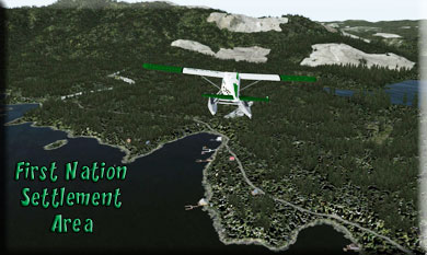
Leg: To 1st Nation Settlement from Port Alice Logging
Initial Course: 289°
Leg Distance: 7 miles
Leg Altitude: 1200 Feet
Information: Leaving the Port Alice Logging port, set a course for 289° for the First Nation Settlement Area. You will be flying with the shoreline to starboard. You will see the First Nation Settlement Area in about 7 miles.
- Approximately 8000 years ago, groups of First Nations began harvesting salmon in the Fraser Canyon, and for 3000 years they exploited the resources of the future Vancouver area. One of the three Salishan groups that have overlapping claims to the Vancouver area as a traditional territory is the Squamish (Skwxwú7mesh), whose territory expanded from Howe Sound to include False Creek and Burrard Inlet. Their major settlements were Whoi Whoi (Xwáýxway) in Stanley Park, Snaug (Senakw), near the present day Burrard bridge on False Creek, and Xwemelch’stn at the mouth of the Capilano River. The other two groups, which shared the Halkomelem [Salishan] language, were the Tsliel-waututh and the Musqueam (Xwméthkwyiem). The Tsliel-waututh, whose plankhouse village was at the mouth of Taylor Creek on the north side of Burrard Inlet, shared the resources of the area through marriage or other uniting relationships. The complex social organization of the first peoples was based on an accumulation and redistribution of wealth. Such wealth and potentially sticky political issues were kept in check by intermarriage and potlatching. Failing that, occasional armed conflict was resorted to.
Coal Harbour Quarry From 1st Nation
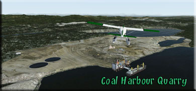
Leg: To Coal Harbour Quarry from 1st Nation Settlement
Initial Course: 031°
Leg Distance: 7 miles
Leg Altitude: 1200 Feet
Information: Over the First Nation Settlement Area, turn to starboard to a new course of 031°. You will fly over the Coal Harbour Quarry in 7 miles.
- Now a hub for marine traffic, Coal Harbour was once a thriving whaling station, the last one on the North American coast when it closed in 1967. Then, in the 1970s it became a mining town again when the Island Copper Mine was in operation until it closed in 1996. Today the residents rely on fishing, logging and acquaculture.
- During World War II, the village was a bustling base for the Royal Canadian Air Force and their “flying boat” coastal reconnaissance missions.
Rupert Inlet Cabins From Coal Harbour
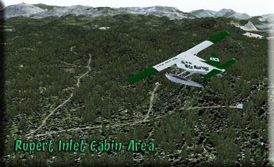
Leg: To Rupert Inlet Cabins from Coal Harbour
Initial Course: 104°
Leg Distance: 8 miles
Leg Altitude: 1200 Feet
Information: Over the quarry, turn to starboard to a heading of 104° for 8 miles. This will take you over the Rupert Inlet Cabin area.
CYZT (home) From Rupert Inlet Cabins
Leg: To CYZT from Rupert Inlet Cabins.
Initial Course: 002°
Leg Distance: 7.5 miles
Leg Altitude: 1200 feet down to landing altitude
Information: From the Rupert Inlet Cabin area, turn to a heading of 002° and head back to CYZT (Port Hardy Airport). Land. (Safely!)
|