| Return to Misty Moorings - Whistler Aerodrome TripTic |
Vancouver Intl SPB to Whistler Aerodrome
Route Notes
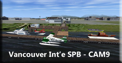
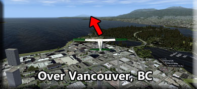
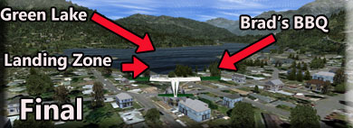
Route Overview If you are going skiing or sight-seeing at Whistler Mountain, there are three ways to get to the mountain. You can use an automobile from Vancouver and drive up the beautiful "Sea to Sky" highway (#99), you can take a train that follows the scenic route of the higway, or you can go by seaplane from Vancouver CAM9 seaplane base right at the Vancouver Airport. You will fly directly over Vancouver, and turn to fly up the Burrard Inlet to Squamish, then follow the river and the Sea to Sky Highway up into the Coastal Mountains to arrive at Green Lake. The Parking is on the southern shore that you will pass over while landing. Watch for the Brad's BBQ (red) building to starboard as you land. FROM: CAM9 Vancouver Int'l SPB Leg: From CAM9 (Select Dock for Starting Point) Information: You are flying near a busy airport. We are going to circle low (1200 feet) under the incoming ILS or departing vectors for commercial aircraft. The route takes us out over Richmond then turns to port going directly over the city of Vancouver. Guide: Vancouver is a city in British Columbia, Canada. With its location near the mouth of the Fraser River and on the waterways of the Strait of Georgia, Howe Sound, Burrard Inlet, and their tributaries, Vancouver has, for thousands of years, been a place of meeting, trade and settlement. The presence of people in what is now called the Lower Mainland of British Columbia dates from 8,000 to 10,000 years ago when the glaciers of the last ice age began to disappear. The area, known to the First Nations as S'ólh Téméxw, shows archeological evidence of a seasonal encampment ("the Glenrose Cannery site") near the mouth of the Fraser River that dates from that time.
The first Europeans to explore the area were Spanish Captain José María Narváez in 1791, and British naval Captain George Vancouver in 1792. The area was not settled by Europeans until almost a century later, in 1862. The city grew rapidly following completion of the Canadian Pacific Railway (CPR) transcontinental line from Eastern Canada, allowing for continuous rail service in the late 1880s. Chinese settlers were increasingly a presence in the area following completion of the CPR. Subsequent waves of immigration were initially of Europeans moving west, and later, with the advent of global air travel, from Asia and many other parts of the world. Leg: From Vancouver, BC to Lighthouse Park Point Information: You fly over the city of Vancouver on a heading of about 288 and fly to Lighthouse Park Point about 10 miles ahead. When you get to the point, fly over it and be ready to turn slowly to starboard going up the Charlotte Channel. Guide: Vancouver's history is interesting. Spanish Captain José María Narváez was the first European to explore the Strait of Georgia in 1791. He landed at Point Grey and entered Burrard Inlet. In the following year, 1792, the British naval Captain George Vancouver (1757–1798) met the Spanish expedition of Dionisio Alcalá Galiano and Cayetano Valdés y Flores off Point Grey, and together further explored the Strait of Georgia. Vancouver also explored Puget Sound in the present day Seattle area. Vancouver, surveying in small boats with his officer Peter Puget, arrived at the present city of Vancouver before the Spanish. They first landed at what Vancouver later named Point Grey. Puget informally called the place Noon Breakfast Point. Puget's name was officially given to the southwest tip of Point Grey in 1981.
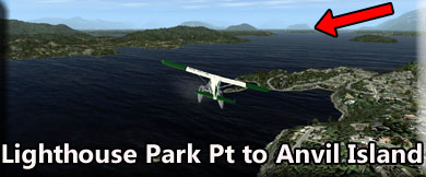
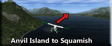
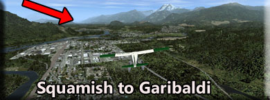
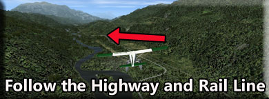
Simon Fraser was the first European to reach the area overland, descending the river which bears his name in 1808. Despite the influx of the Fraser Gold Rush in 1858–59, settlement on Burrard Inlet and English Bay was almost unknown prior to the early 1860s due in large part to the lack of interest in the area as the access to the BC interior was via the City of New Westminster and the Fraser River and also due to the power of the Squamish chiefs over the area. Robert Burnaby and Moberly camped and prospected for coal in what is now Coal Harbour in Vancouver in the summer of 1859. In general they got along fine with the native people. Robert Burnaby wrote "Our [spare] time has been occupied in exploring all the ins and outs of this Inlet, which I prophesy will become one of the greatest naval rendezvous and centres of commerce on this side of the world."[4] (Letter to his family August 31, 1859. The original is at Burnaby Village Museum). The first non-native settlement in the city limits of Vancouver was about 1862 at McCleery's Farm, in the vicinity of what is now the Southlands area Leg: From Lighthouse Park Point to Anvil Island Information: You will fly up the Burrard Inlet on a course of 342. Horseshoe Bay will pass to Starboard as will Boyer Island. You will then come up to Anvil Island just off your port side. There you will turn toward Squamish. Guide: Lumbering was the early industry along Burrard Inlet, now the site of Vancouver's seaport. The first sawmill began operating in 1863 at Moodyville, a planned settlement built by American lumber entrepreneur Sewell "Sue" Moody. In 1915, it expanded as a municipality and was renamed "North Vancouver"; the name Moodyville still applies to the Lower Lonsdale district, though more as a marketing term than in common usage (Moodyville proper was a few blocks to the east). The first export of lumber took place in 1865; this lumber was shipped to Australia. In 1867, the first sawmill on the south shore of Burrard Inlet, Stamp's Mill, began producing lumber at what is now the foot of Dunlevy Avenue in Vancouver. A site for the mill was originally planned at Brockton Point in what is now Stanley Park, but the Brockton Point site proved infeasible due to nearby currents and shoals which made docking difficult. The largest trees in the world grew along the south shores of False Creek and English Bay and provided (amongst other things) masts for the world's windjammer fleets and the increasingly large vessels of the Royal Navy. One famous sale of trees cut from the Jericho neighbourhood (west of Kitsilano), was a special order for the Celestial Emperor of China consisting of dozens of immense beams for the construction of The Gate of Heavenly Peace in the Forbidden City, Beijing. Millworkers and lumberers were from a wide variety of backgrounds – mostly Scandinavians and Nootkas – who were also brought to the inlet to help with the local whaling industry. At first, Squamish typically did not work in the mills. Leg: From Anvil Island to Squamish, BC Information: Anvil Island passes to port and you turn to 005* heading for the city of Squamish, BC. It is just past the point of land on your forward route. Guide: The word "Squamish" means "Mother of the Wind," and with the strong winds that still blow at the north end of Howe Sound, it's not hard to understand how the original Coast Salish inhabitants came up with the name for this territory. The Squamish Nation lived on this land for centuries, hunting for bear, moose and deer in the lush coastal forests and fishing in local rivers. The first documented contact with European explorers was in 1792 when Captain George Vancouver sailed into Darrell Bay, south of Squamish, and engaged in trade with the local native people. Although British Columbia came alive in the 1850s th the Fraser River Gold Rush, it wasn't until the late 1880s that the Squamish area was first settled with farmers hailing from Eastern Canada. The first school was built in 1893 and the first hotel in 1902. Hops, hay, and potatoes were among the key early crops for farmers. The Britannia Mine opened in 1904, and would produce 56 million tons of copper over its 70-year life span. Also, forestry took off at the turn of the 20th century, and by the 1920s, new technologies like high-lead logging (using cables, yarders, and loaders) had increased the yield in areas like Valleycliffe, Crumpit Woods, and Alice Lake. Squamish was incorporated as a village in 1948 as a district municipality in 1964. But geographically and culturally, Squamish remained isolated into the mid-20th century since the only transportation link was the boats that came carrying supplies up Howe Sound. That changed dramatically when a railway link to Vancouver was completed in 1956. Two years later, Highway 99 (now generally known as the Sea-to-Sky Highway) between Vancouver and Squamish opened. This enabled upwards of 25% of Squamish's population to start commuting to work in Vancouver or Whistler, a trend which persists to this day. In 1961, Squamish gained worldwide attention when Jim Baldwin and Ed Cooper became the first climbers to scale the Grand Wall of the Stawamus Chief granite monolith over a period of six weeks. That set the tone for the outdoorsy, adventure sports magnet that Squamish would become. Leg: From Squamish to Garibaldi Information: Passing over Squamish, go to a 344* course and you will fly directly over the Brackendale Airport. This is a good "stopover" place. the runway is almost on your heading, it is an easy approach and landing, and a touch and go keeps you on your way, but fuel is available here if you need to top off. As you fly over Brakendale Airport follow the highway and turn a little to starboard eventually coming to about 357*. The key to these last legs of the trip is to FOLLOW the HIGHWAY. Watch your altitude, start moving up to 2500 feet. Guide: Garibaldi, originally named Daisy Lake and also known as Garibaldi Lodge and Garibaldi Townsite, is an abandoned locality in British Columbia, Canada, on the Cheakamus River around its confluence with Rubble Creek and just south of Daisy Lake. The townsite had been in existence since shortly after the opening of the Pacific Great Eastern Railway, with its post office opening in 1916, and it had been the site of Garibaldi Lodge, one of several rail-tourism lodges along the rail line, the most well known in this locality being Rainbow Lodge at Alta Lake. The settlement's name was changed from Daisy Lake to Garibaldi in 1932 by dint of association with the intended main basetown for Garibaldi Provincial Park Although some buildings remain, including public works facilities, the community is officially depopulated due to the geohazard posed by The Barrier, a lava dam holding back Garibaldi Lake that has let go at various points in the past; Rubble Creek gets its name from the large boulder field created by successive degenerations of the Barrier Plans for a ski development at this location were ended when evacuation was ordered, property owners and residents of the townsite were ordered by the provincial government to evacuate Garibaldi amid much public controversy as to whether it was really necessary or not. To compensate property owners, lots were offered in the new Pinecrest and Black Tusk Estates subdivisions a bit further north, and out of the way of the debris path from The Barrier. The name Garibaldi Lifts Company, the founding company of what is now Whistler Blackcomb, was chosen in anticipation that Garibaldi would be the major resort in this area Leg: Following the Highway to Giribaldi Information: The navigation goes "highway vfr" from here on in. You'll be following the highway and the rail line all the way to Whistler Mountain. Stay in the valley area. You should be increasing altitude to about 2500 feet. Guide: Highway 99, also known as the Sea to Sky Highway, the Squamish Highway, Route 99, or Whistler Highway, is the major north-south artery running through the Greater Vancouver area of British Columbia from the U.S. border, up Howe Sound through the Sea to Sky Country to Lillooet, and connecting to Highway 97 just north of Cache Creek. The number of this highway is derived from the old U.S. Route 99, with which the highway originally connected. The highway currently connects with Interstate 5 at the international border This highway received the '99' designation in 1942 after completion of the King George VI Highway (1940) to the U.S. border, and it originally shared an alignment with Highway 1 from Surrey to Vancouver via the Pattullo Bridge and Kingsway. The current freeway alignment of Highway 99 between 8th Avenue in South Surrey and the North Arm of the Fraser River opened in 1962 as Hwy. 99 and was called the Deas (Island) Throughway. Between 1964 and 1973, the freeway alignment of Highway 99 was designated Highway 499. The Oak Street Bridge was built in 1957 to cross the North Arm Fraser River and the Deas Island Tunnel was built 1957-59 (renamed the George Massey Tunnel in 1967) to cross the Fraser River. Tolls were collected at the crossings but were rescinded by the provincial government around 1963-64. In 1957, the northern end of Highway 99 was moved from downtown Vancouver, across the Lions Gate Bridge and west to the village of Horseshoe Bay, following Marine Drive through West Vancouver. Highway 99 was re-aligned via Taylor Way, just east of the Park Royal Shopping Centre, to the Upper Levels Highway and extended to Britannia Beach one year later, extending to Squamish in 1959, and to Pemberton in 1966. Finally, in 1992, the just-paved Duffey Lake Road between Pemberton and Lillooet was made part of Highway 99, and the section of Highway 12 between Lillooet and Highway 97 was re-numbered 99. The portion of the highway between Lillooet and Pavilion was part of the route of the Old Cariboo Road.
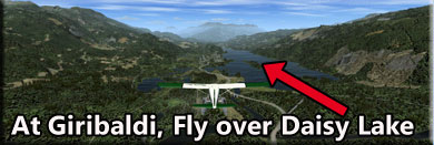
The total length of Highway 99 from the U.S. border to the Highway 97 junction is 409 kilometres (254 mi). In 2006 the UK's The Guardian newspaper listed the Sea to Sky as the 5th best road trip. Leg: From Giribaldi to Whistler Mountain Area Information: Over Daisy Lake, start increasing your altitude to 3500 feet. As you reach the end of Daisy Lake, you will see a mountain ahead, there is a valley to starboard. Follow the highway up that valley making a slow "S" route until you approach lake area of Whistler Mountain. Guide: Daisy Lake, also referred to as Daisy Lake Reservoir, is a reservoir on the Cheakamus River in the Sea to Sky Corridor of southwestern British Columbia, Canada, just south of the Resort Municipality of Whistler and immediately north of the abandoned townsite of Garibaldi (which until 1932 had been also named Daisy Lake). Daisy Lake Dam was built in the 1950s with the reservoir created merging the former natural Daisy Lake and another named Shadow Lake. The reservoir supplies the Cheakamus Powerhouse on the Squamish River via a tunnel bored beneath the mountain range dividing the two rivers. There is a BC Hydro-operated recreation area just above the dam, and public campgrounds and picnic tables at Brandywine Falls Provincial Park, which is near the head of the lake. The upper reaches of the lake are visible from viewing platform on the north side of the falls and also from points along the hiking trails lining the cliff edge above the Cheakamus River north and south of the falls.
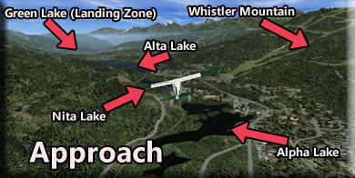
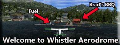
The northern, western and southwestern sides of Daisy Lake are influenced by lava flows composing the Cheakamus Valley basalts. Leg: Approaching Whistler Aerodrome (CAE5) Information: As the highway turns to port, follow it. Directly ahead will be Whistler Mountain, you will see the ski trails. Follow the highway and you will see four lakes. The first little lake "set" is Alpha Lake. The second lake is Nita Lake, the thrid and larger lake is Alta Lake. The last lake ahead is Green Lake, this is the site of the Whistler Aerodrome (CAE5). As you come over the lakes, reduce your altitude. The landing zone altitude is 2082 Feet. Guide: The resort appears regularly in "Best of" lists from around the globe, winning for its incomparable skiing and boarding, as well as for its hotels, restaurants and golf courses. Whistler became even more world-renowned as the site of the alpine and Nordic venues for the Vancouver 2010 Olympic and Paralympic Winter Games. Blending the charm of an alpine village with the amenities of an urban centre, the pedestrianized Whistler Village offers fine dining, vibrant nightlife, eclectic boutiques, revitalising spas and luxurious hotels. Leg: Final Approach Information: You will be landing on the last lake, Green Lake. As you cross over the shoreline, you will see your docking point at a Brad's BBQ to starboard on the shore. Land and Taxi Back to Brad's BBQ. NOTAM: In winter this lake freezes, so you will be landing on ice. BE VERY CAREFUL not to run into any ice fishing shacks that are on the lake or vehicles going and coming from them!
Guide: Welcome to the Whistler Resort Area. Whistler ski resort in in a class of its own and is justifiably considered one of the hottest ski destinations in the world. The Whistler ski resort is massive and it offers amazing terrain diversity and a very efficient lift system. However Whistler Canada is so much more than just the skiing and snowboarding and a Whistler ski holiday can also include an abundance of off-slope activities. The pedestrian-only Whistler Village is full of restaurants, bars and plenty of shops to delight any shopper-holic.
Whistler hosted the alpine skiing events of the 2010 Vancouver Winter Olympics as well as the bobsled, luge and skeleton events. Some ski resorts benefit hugely from the profile of hosting the Winter Olympics, but Whistler Blackcomb was already attracting thousands of visitors from around the world, so it probably didn't gain much from the publicity. Whistler is a household name in the skiing and snowboarding fraternity. Whistler Blackcomb is a mega-resort! Whistler Canada is the largest ski resort in North America and the biggest ski area in the world outside of Europe. Whistler Blackcomb ski resort consists of the interconnected Whistler Mountain and Blackcomb Mountain, and it has an incredible 8,171 acres (3,307 hectares) of terrain, a huge vertical drop of 1,609 metres, over 200 marked trails, and plenty of off-piste opportunities. The Whistler ski resort is so big that instead of having a trail map, they have an atlas! |