
Prince Rupert to Big Fall Hydro Location
This is a beautiful and interesting boat trip from the Prince Rupert SPB dock to Brad's Bait & BBQ in Big Fall Cove (Big Fall Hydro area). You will pass by some beautiful rapids, under bridges, narrow passages on your way out of Prince Rupert. This will take some boating skills as some of the rapids areas are narrow.
The trip is about 45 miles long ... can be done in a run-about, powerboat, or a 55 foot yacht. And, of course at the end of your trip, the famous Brad's BBQ waiting for you. Order up and you can sit on the picnic table on the dock and watch the beautiful waterfall.
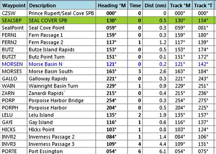
1. Your trip starts at the Prince Rupert SPB. Do a "go to airport" and you will be placed at the dock.
2. As you leave the dock, turn a little to starboard and round the point at the coast guard station. Once around the point, set a heading of about 146. At FERN1, the passage bends to port, set a new course of about 118 to stay in the passage to FERN2 1.1 miles ahead (where Fern Passage veers to starboard).
3. At FERN2, where the Passage veers right, set a course of 154 for .6 miles to the Butze Islands.
4. At the Butze Islands, you must go between them ... there is a rapids in this area so watch for tricky currents. You will see the little islands, slow down and go between them carefully. After you clear the islands, Butze point is ahead to starboard.
5. Go around Butze point coming to a heading of 164 for 2.5 miles. (You are at Morse1) You are now crossing the Morse Basin. As you reach the end of the basin, slow down and prepare to make some fine maneuvers for another rapids area at Morse2.
6. Ahead of you is Mount Stewart (1400 feet) as you approach you will turn to starboard. As you approach the shore, you will see a narrow passage to starboard ... that is the beginning of Galloway Rapids ... where we are going next.
7. As you round the point, you will see a bridge ahead of you, go under that bridge (Waypoint GALLO).
NOTAM: after the bridge there are small islands you must go around, go slow in this area!
8. After the bridge and the small islands, set a heading of 229 for 1 mile to WAIN). You are in the Wainright Basin and toward the center of it you will make a slight correction to port to line up for the Zanardi Rapids. What looks like an island (but is a peninsula) juts out from starboard, go around it and head for the railroad bridge.
NOTAM: The industrial area to port is the chip yard for the Port Edwards Pulp Mill.
8. After the bridge you are entering Porpoise Harbor (the home of the paper mill and some shipyards. Make a slow turn to port to about 150 degrees and go down the center of the harbor. You will pass the Pulp Mill to port and some large ships docked there.
Notam: After you pass the pulp mill, you will pass by the community of Port Edwards (a paper-mill town!).
9. After Port Edwards, you will see Lelu Islanding coming up ahead, you will go to the port side of this island. (Waypoint LELU)
10. As you approach Gay Island, (Lelu to starboard), look for a very narrow channel to the left.
11. As you exit this small passage by Gay Island, steer a little to port to follow the channel there. That will be Inverness Passage and we will travel it's length .. about 6.5 miles on a rough heading of 105.
12. Hicks Point will pass by starboard as you enter the Inverness Passage. Look to port and you will see the first cannery along the shoreline. For a little sight-seeing, veer a little to port and pass close by the cannery .. then continue down the Inverness Passage.
13. About 1 mile ahead, you will find a second cannery, again come along the port shoreline to view it as you pass by.
NOTAM: If you have Google Earth. Set it to here with the Street View ... you can actually see what that road behind the cannery looks like!
14. After the second cannery, just cruise along the port shoreline to Gust Point, 4 miles ahead to Port. We will go around that point turning to port to go into the mouth of the Skeena River.
15. As you come around Gust Point to port, set a heading of 68 degrees for Veich Rock (Point) you will see ahead to starboard.
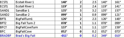
16. At Veich Rock, look for the next point to starboard about 1 mile away, That will be the Port Essington Point. We will go around that point to starboard into the Ecstall River.
17. As you approach the Ecstall, you should steer to pass between Skip Rock to port and Ecstall Island to starboard.
18. Turn to starboard around Ecstall Island into the Ecstall River which we will follow to the Big Fall Hydro area.
NOTAM: the power lines you see on the port shore are coming from the Big Fall Hydro plant. We will be going about 10 miles down the Ecstall River ... with a few turns to avoid a major island before we turn into Big Fall Cove.
NOTAM: Watch for the Heyward River coming up to Port, about a mile after that, there is a large sandbar in the middle of the river. Pass to the left of it. It is best just to follow the port shore from here forward. After passing the island, you have 5 miles until a port turn into Big Fall Cove.
19. Madeline Creek will outfall to starboard and ahead you will see a sharp point to port, Go around that point steer to pass close by the shore of the island ahead.
20. After passing the island, set a heading of 108 and head for the port shore, the entrance to Big Fall Cove is marked with green and red buoys. Turn into that channel.
21. Notice the channel marker buoys. Stay between them as they curve to port around a large sand bar and point you right at Brad's Bait & BBQ ahead 1 mile.
NOTAM: To your left you will see Big Fall Cove Cabin and to the right of Brad's is the "Big Fall" waterfall. The Power Plant is above that dam on the top of the waterfall.
Hope you enjoyed the cruise ... now pull up to the dock at Brad's and order a big BBQ sandwich and a beverage of your choice. Hike around the area ... it is a beautiful place to spend an evening.
===============================================
NOTAM: Print-friendly copy here with FSX Flight Plan.
Doug Linn
Charter Manager
Misty Moorings, Inc
contact@mistymoorings.com