
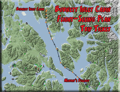
Destination: Burnett Inlet Cabin
Route Notes
- This Scenery is for "Return to Misty Moorings" only.
- Minimum Altitude: 500 feet
- Landing zone is: Water, Does not Freeze in Winter
- GPS for destination: N56 09.75 W132 27.97
- Distance approximately 55 miles
- Download PRINT-ABLE copy HERE
- Flight-Seeing Flight Plan & Map HERE
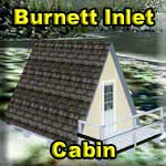
Burnett Inlet Cabin
Burnett Inlet Cabin is a small isolated "A" frame cabin in Burnett Inlet, this location is a perfect place to find solitude and live off the land. Burnett Inlet is a narrow fjord on Etolin Island. Arriving here is a pleasure as the surrounding terrain in the fjord seems to climb straight up in places. The island contains a population of introduced elk and plenty of fishing, hunting and exploration await those who stay here. Bear frequent the area so take all necessary precautions. Did you know that although the triangle shape of the A-frame has been present throughout history, it saw a surge in its popularity around the world in the post-World War II era, roughly from the mid-1950s through the 1970s. It was during this time that the A-frame acquired its most defining characteristics and this cabin was one of the first A-frame cabins in the region.
The cabin and small floating dock is all that you'll find so visitors should be sure to bring all necessary supplies to this location.
WaveTop VFR Plan
FROM : Murphy's Pullout 8K9
TO: Burnett Inlet Cabin
This trip starts at Murphy's Pullout, 8K9. You will need a float plane (or amphibian for this trip).
Next Waypoint: Guard Lighthouse
Course: 286 degrees (approximate 29 Runway Heading)
Distance:
5.5 miles
- You will be initially flying on a heading of 286 degrees as you follow the Tongass Narrows (the waterway separating the city of Ketchikan, on your right from Gravina Island, on your left. As we gain altitude we see Ward Cove come into view to starboard.
- The "Return to Misty Moorings" Totem Bight operations center is on the western point of the cove. This is where we do the heavy maintenance for small float-equipped aircraft in the area.
- As we come to the end of the Tongass Narrows, Vallenar Point passes to our port side and Point Higgins to starboard. Look ahead and you should see the two tiny Guard Islands and the Guard Lighthouse. Adjust your course to fly over the lighthouse.
Next Waypoint: Caamano Point
Course: 297
Distance: 4.3 miles
We are flying toward Caamano Point, the point of land ahead. We will be flying to the port side of the terrain, putting the shoreline to starboard. When Caamano Point is exactly at 3 o'clock, then your are ready for your next waypoint (Niblack Point).
- While we are flying, a little about the Guard Lighthouse. For years Native Americans and Russian fishermen, hunters, and traders had plied the waters near Ketchikan, and countless lost vessels attested to the dangers of the shallow inlets and dense fog. Although only two years after the US acquired Alaska the Senate requested a review of the Northwestern coasts to determine suitable spots for lighthouses, funding was not provided for another thirty years. Several day beacons and buoys were installed as minor aids to navigation, but it wasn’t until the Gold Rush, triggered by the 1896 discovery, that private citizens, and traders clamored loudly enough for the Lighthouse Board to receive funding for much-needed light stations.
- In November of 1903, construction began on Guard Island when a force of men started clearing and grading a site for the lighthouse. Illuminated for the first time on September 15, 1904, the 34-foot wooden tower housed a minor optic lens lantern that produced a fixed white light. Mounted on the north face of the tower was a fog bell, mechanized to strike every twenty seconds. Also on the island were a 1 ½ story frame keeper’s cottage, a boat house, and an oil storage house. No longer did the mariners have to rely on their rule “three knots and a fervent prayer” to successfully navigate the narrows.
- However, the wood used for Guard Island Light Station, as well as for several other contemporary Alaskan lighthouses, soon deteriorated in the harsh conditions. After all, Ketchikan is one of the rainiest places on earth, with 176 inches annually, and the winters are foggy, windy, and freezing cold. By the 1920’s all the lighthouses except Eldred Rock (1906) were falling apart, and in 1922 Congress authorized the reconstruction of Guard Island Light. In 1924, the dilapidated light tower was replaced with a new single-story rectangular tower of reinforced concrete. The antiquated bell signal was replaced with a diaphone air signal that gave a five-second blast every 25 seconds. Additionally, another keeper’s house was built to provide quarters for two keepers and their families.
- Later in its history, Guard Island Lighthouse was converted into a stag station, run by four Coast Guardsmen. For company, the crews usually had a dog or two, but for several years the station was well known for its pet deer. In fact, during the first few months of 1966, there were actually two fawns at the lighthouse, Wickie and Kado. The station dogs were not too happy with the situation, as they had been supplanted as man’s best friend.
- The deer had a pampered existence at the lighthouse. Wickie loved to be petted and to have her chin and ears scratched, and, at night, she would sleep at the foot of Daniel Young’s bunk. A feeding box was kept in one corner of the living room, but the deer didn’t exactly keep to their vegetarian diet, becoming quite fond of such delicacies as pepperoni and sausage. The deer were free to roam around the entire island and wandered in and out of the dwelling at will. The only complaint the men had regarding their unique pets is that they couldn't figure out how to housebreak them.
- The point of land coming up on our right is Caamano Point. For fishing, it is good for early silvers and bottom fish. You can do very well fishing about 50 yards off of a place called "the rock pile." However, you have to be very careful because the weather here comes up quickly. If you are interested, you can check with Clover Pass Resort, They rent some 18' fiberglass boats with a rag tops. But if you decide to do it, don't go too far out in a skiff like that. As Caamano point passes to starboard, we remain on this heading. We will be following the coastline about 2 miles offshore. We are now flying up the Clarence strait.
When Caamano Point is at 3 o'clock change heading to 279 ... (flying a mile or so off shore up the coast).
Next Waypoint: Niblack Point
Course: 279
Distance:
Niblack point is 6 miles ahead, you will know this point because after it the island's terrain begins to curve to starboard. When you are at Niblack Point, you are ready for the next waypoint, Ship Island.
- We are now flying up the Clarence Strait. Behind those ridges to starboard there are some excellent fishing lakes, and we fly to most of them. Smuggler's Lake is one of my favorite spots, the fishing there is always good. That's about 5 miles away at 3 o'clock. And not much further is Bear Lake. It's about 11 miles ahead at 2 o'clock. And yes, there ARE bears there ... but they are everywhere up here. You are coming up on Niblick's Point.
When Niblick's Point is at 3 o'clock, alter heading course to 298 ... you are heading for Ships Island, look for a white blinking light on a tower.
Next Waypoint: Ship Island
Course: 298
Distance:
5.3 miles
... you are heading for Ship Island, look for a white blinking light on a tower located on a very small island. When over Ship Island, you are ready for the next waypoint, Misery Island.
Next Waypoint: Misery Island
Course: 321
Distance: 9.5 miles
- Since we have some time, let me tell you about tiny Ship Island ... even something so small can make the headlines. Some scientists did a tree-ring analyses of 23 bark-stripped trees there. They discovered that natives were collecting tree bark between 1718 and 1912 ... they could tell this from scars on the trees. Natives had landed on this hazardous stretch of Clarence Strait to take tree bark during the 195 years spanned by the sample. About a third of the trees sampled had multiple scars indicating repeated use of individual trees. The most intensive forest use occurred between 1852 and 1895, while the lack of bark scars after 1912 marks a decline in traditional Native craft. A burst of bark-stripping between 1779 and 1787 may be associated with the legendary last battle between the Stikine Tlingit of Alaska and the Tsimshian of British Columbia. So even tiny Ships Island adds to the history here.
- The land mass on the starboard side ends with a tiny bit of land called Misery Island. And near it is Myers Chuck, a neighborhood in the City and Borough of Wrangell, Alaska. In the 2000 census, there were 21 people, 9 households, and 7 families residing in the CDP. The population density was 36.0 people per square mile. If you don't care for big city living, here's your dream location!
Misery Island is the last little island on the land mass to starboard. Adjust your route to fly directly over Misery Island, then line up for Ernest Point, on a heading of 315.
Next Waypoint: Ernest Point
Course: 315
Distance: 6.9 miles
- As we fly on this leg, we pass a body of water to starboard called Ernest Sound. This sound is described as a strait in Southeast Alaska, U.S.A. It extends 48 kilometres (30 mi) southwest, from the mouth of Bradfield Canal to Clarence Strait, separating Wrangell and Etolin Islands from the mainland. It was first traversed and charted in 1793 by James Johnstone, one of George Vancouver's officers during his 1791-95 expedition. Vancouver later named it "Prince Ernest's Sound", after the later Ernest Augustus I of Hanover.
- Ernest Point is the nearest point on the island ahead called Onslow Island. The body of water we are flying over to reach Ernest Point is Canoe Pass.
When you reach Ernest Point, you are ready to make a course adjustment for the next waypoint, Mabel Island.
Next Waypoint:Mabel Island
Course: 316
Distance: 4.2
Turn to 316 and 4.2 miles ahead, you will find Mabel Island It is shaped like and "H" with a period in front of it .. "*H"
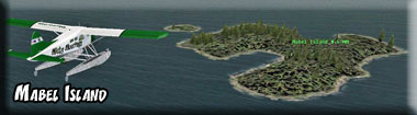
Adjust your heading to cross directly over Mabel Island.
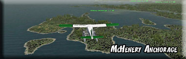
Next Waypoint:McHenry Anchorage
Course: 315
Distance: 4.3
Your next waypoint is McHenry Anchorage. It is an inlet of water just beyond the next point 4.3 miles ahead. when you are over the anchorage (not the point), then you are ready for the next waypoint, Cannery Point.
Next Waypoint:Cannery Point
Course: 319
Distance: 4.6
Over McHenry Anchorage, set your heading for 319 which will take you to a flyover of Cannery Point, a point of land coming out from the starboard shore. Over Cannery Point, you are ready for the next waypoint, Burnett Inlet.
Next Waypoint:Burnett Inlet
Course: 344
Distance: 4.6
When you pass over Cannery Point, alter your heading to 344 and you will be looking at Burnett Inlet about 5 miles ahead. Fly to the entrance of Burnett Inlet and get into landing configuration. Look closely and you will see a tiny red buoy in the center of the channel. Fly up the inlet.
The beautiful inlet narrows, then eventually spreads out into a wider area where the inlet ends. From the narrow part of the inlet, the cabin is about 2 miles ahead. Watch for the cabin on the starboard side of the inlet.
Next Waypoint:Burnett Inlet Cabin
Course: 344 (Follow the inlet)
Distance: 3 miles
Welcome to Burnett Inlet Cabin.
Doug Linn
Charter Manager
Misty Moorings, Inc
contact@mistymoorings.com
(Revised 07.04.2012)