
Destination: Hunter Bay Cannery
Route Notes
- This Scenery is for Return to Misty Moorings only.
- Minimum Altitude: 1200 Feet
- Landing zone is: Water, does not freeze in winter
- GPS for destination: N54 52.26 W132 18.56
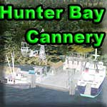
Hunter Bay Cannery
The Hunter Bay Cannery is located on Hunter Bay on the southwest side of the Prince of Wales Island. It's about 40 miles direct from Ketchikan. This facility processes the fish from the many fishing fleet boats operating out of their bases nearby. There is a parts shop and restaurant, mostly for the fishermen and pilots. Overnight lodging is available. There is plenty of room to moor your boat or your floatplane along the docks of the cannery. The draft depth of the channels is 35 feet. A ferry boat provides transport for cargo, shipment of product and staff transportation to and from the facility daily.
The Cannery has to be one of the most visited destinations from the old Misty Moorings sceneries. Just based on it's location, it's fun to fly in and out of with beautiful scenery all around. Look for the channel buoy's and boats to help you navigate through the channel. There is also a nearby waterfall, check it out! Don't forget to stop by the nearby Klinkwan fish camp when you get a chance!
WaveTop VFR Plan
From: Misty's Place
To: The Hunter Bay Cannery
This trip starts from Runway 17 at Misty's Place.
COURSE: After liftoff, turn sharply to port and fly out over Bostwick Inlet to the last starboard point which is Seal Cove Rocks.
COURSE: At Seal Rocks, turn to starboard to a heading of 176. Your next waypoint is Dall Head, the last point of land ahead on your starboard side, about 4 miles ahead.
COURSE:Over Dall Head, set a course of 220 for about 14 miles. This will take you into the heart of Moira Sound.
- Here you are crossing the Clarence Strait. This body of water was originally named the Duke of Clarence Strait. It can be described as a strait in southeastern Alaska, in the Alexander Archipelago. This strait separates Prince of Wales Island, on the west side, from Revillagigedo Island and Annette Island, on the east side. Clarence Strait is 126 miles long, extending from Dixon Entrance to Sumner Strait.
- Clarence Strait was named in 1793 by George Vancouver in honor of Prince William, Duke of Clarence. Jacinto Caamaño, who had explored the region a year before Vancouver, named the strait Entrada de Nuestra Senora del Carmen.
COURSE: You will pass over Whiterock Island at the mouth of the Moira Sound. Smaller Moira Island will be further to starboard. Continue on your heading.
COURSE: You will see the sound will split to port and to starboard. You will want to take the port channel. This is the South Arm of Moira Sound.
- NOTAM: The West Arm goes to your 1 o'clock. The South Arm to your 10 o'clock. Turn to port into the South Arm.
COURSE: At the end of the South Arm, turn to port to a heading of 177 to your next waypoint ... a small lake just ahead of a small mountain. Reduce altitude to about 800 feet.
- NOTAM: SLOW DOWN! Reduce speed and add flaps be able to make the turns ahead. (90 mph max).
COURSE: Over the lake, look for a small river ambling off to starboard. Follow the river to Hunter Bay on an approximate heading of 225.
- NOTAM: Get into landing configuration, stay slow, flaps, altitude 800 feet.
COURSE:Over Hunter Falls on your last turn toward Hunter Bay, you should be at about 400 feet approaching the landing zone ahead.
Welcome to Hunter Bay Cannery.
Doug Linn
Charter Manager
Misty Moorings, Inc
contact@mistymoorings.com