
Destination: Kimsquit Logging camp
Route Notes
- This Scenery is for Return to Misty Moorings only.
- Minimum Altitude: 1200 Feet
- Landing zone is: Dirt, snow in winter
- GPS for destination: N52 53.10 W127 5.53 alt 80'
- Print-Able copy HERE
- Flight Seeing Plan available HERE
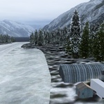
Kimsquit Logging Camp
Early in the 20th century, logging operations in the Kimsquit watershed took on a new and important pace. Starting in 1917, Pacific Mills Limited constructed a train access point and rail operations began. Even though they were limited in reach, they were able to make an impact. Tall stands of Douglas Fir in the lower valley were now accessible and the operation lasted for several years. The planned expansion of the railway into a larger terminus never occurred though and operations slowed and would not return until the late 1970's. In 1980 Doman Industries assumed control of a large tract of land and constructed a modern 60-crew camp two miles from the beach on the west side of the river. For the next 18 years, operations commenced in the area. In 1997, several environmental issues became apparent. The local Grizzly Bear population was declining, precious resources in the area were taking a major hit, and pollution from the trucks was starting to show up in the water samples taken in the river. As a result, the government of British Columbia stipulated that no more lumber could be harvested in the watershed. Today, there is limited logging at the camps and all operations are heavily monitored. Stiff fines await any infractions. This camp is still active but operations are winding down. It is situated at an unlisted airstrip named "Kimsquit River". Another unlisted airstrip, "Dean River" is only a few miles South of here. There are log floats and log barges on the river hauling away the last few shipments of timber from this area. You can also spot several trucks hauling timber away to be processed.
WaveTop VFR Plan
From:Bella Bella, BC
To: Kimsquit Logging Camp
Overview: There is not a great deal to "discuss" VFR-wise on this trip. It is a rather "directionally" straight-forward flight. You basically fly up the Fisher Channel until it ends at the Kimsquit Logging Camp. This flight is about what you see along the way ... just absolutely striking scenery, beautiful mountains and a waterway that seems to go on forever. The flying is simple ... no dangerous turns ... just a beautiful and easy flight.
Our trip starts in Bella Bella, BC. Here's a little about this location:
-
Early in the 20th century, logging operations in the Kimsquit watershed took on a new and important pace. Starting in 1917, Pacific Mills Limited constructed a train access point and rail operations began. Even though they were limited in reach, they were able to make an impact. Tall stands of Douglas Fir in the lower valley were now accessible and the operation lasted for several years. The planned expansion of the railway into a larger terminus never occurred though and operations slowed and would not return until the late 1970's. In 1980 Doman Industries assumed control of a large tract of land and constructed a modern 60-crew camp two miles from the beach on the west side of the river. For the next 18 years, operations commenced in the area.
-
In 1997, several environmental issues became apparent. The local Grizzly Bear population was declining, precious resources in the area were taking a major hit, and pollution from the trucks was starting to show up in the water samples taken in the river. As a result, the government of British Columbia stipulated that no more lumber could be harvested in the watershed. Today, there is limited logging at the camps and all operations are heavily monitored. Stiff fines await any infractions.
-
This camp is still active but operations are winding down. It is situated at an unlisted airstrip named "Kimsquit River". Another unlisted airstrip, "Dean River" is only a few miles South of here. There are log floats and log barges on the river hauling away the last few shipments of timber from this area. You can also spot several trucks hauling timber away to be processed.
COURSE: When leaving Bella Bella, BC, from the Campbell Island airport (CAF2). Here you are 222 miles southeast of Ketchikan. After take off, come to a course of about 75 degrees. You are looking for what seems to be a wide river coming from between mountains. Fly up that "river" (inlet).
COURSE: As the inlet structure ends, turn to a heading of 29 degrees. Ahead you will see the Fisher Channel which you will now follow for about 60 miles. Sit back and enjoy your trip.
-
The Fisher Channel is a channel in the Central Coast region of the Canadian province of British Columbia. To its west are Hunter and Denny Islands, to its east King Island. It was first charted in 1793 by George Vancouver during his 1791-95 expedition. He named it "Fisher’s Channel" after "a much-respected friend".
COURSE: The course on this trip is simple ... follow the Fisher Channel which later becomes the Dean Channel. You will know you are approaching the Kimsquit Logging Camp when you encounter a large, flat piece of land (almost like a large island) on the starboard side of the channel. This is a delta that is formed from the Dean River which comes out of the landscape to starboard. When you see this, you will begin to see the end to the channel ahead.
COURSE: Shut of the AutoPilot for Flight Seeing (if you had it on) and begin your decent to the logging camp. You will see the landing zone (runway) on the port side of the channel from water's edge forward.
-
The Dean Channel - Ending at the mouth of Cousins Inlet, which is the harbour for the abandoned town of Ocean Falls, the fjord's name changes to Fisher Channel down the west side of King Island. Below Fisher Channel's 40 km (24.9 mi) length the fjord merges with Burke Channel, which is a 70 km (43.5 mi) sidewater of the Dean/Fisher Channel on the east side of King Island, the name of the fjord changes to Fitz Hugh Sound, which is considerably wider than the upper part of the fjord at about 10 km (6.2 mi) in width and is itself about 60 km (37.3 mi) in length. Fitz Hugh Sound passes on the inside of Calvert Island and opens onto Queen Charlotte Sound just northwest of the opening of Queen Charlotte Strait.
-
Opening onto Fitz Hugh Sound in its lower reaches near Queen Charlotte Sound is Rivers Inlet, home of the Wuikinuxv people (Owekeeno). The total length of the fjord from the head of Dean Channel to the mouth of Fitz Hugh Sound is about 170 km (105.6 mi) rivaling Hardangerfjord in Norway for length. If the additional lengths of South Bentinck Arm (45 km (28.0 mi)) and North Bentinck Arm (30 km (18.6 mi)), plus Burke Channel and its shorter companion, Labouchere Channel (15 km (9.3 mi)), and a sidewater of Burke named Kwatna Inlet (25 km (15.5 mi)) were factored in, total length of the fjord complex's waterways is 335 km (208.2 mi) - longer than Sognefjord's 203 km (126.1 mi) and rivaling Greenland's Scoresby Sund's 350 km (217.5 mi).
Hope you enjoyed your flight through this beautiful mountainous scenery.
Welcome to the Kimsquit Logging Camp.
Doug Linn
Charter Manager
Misty Moorings, Inc
contact@mistymoorings.com