
Destination: Moresby Camp
Route Notes
- This Scenery is for Return to Misty Moorings only.
- Minimum Altitude: 1200 feet
- Landing zone is: Water, does not freeze in winter
- GPS for destination: N53 03.14 W132 01.13 Alt 9'
- Print-Able copy HERE
Moresby Camp
A rich diversity of cultures call the island home. Haida Gwaii, the former Queen Charlotte Islands of British Columbia, is arguably one of the most beautiful and diverse landscapes in the world. The islands are the ancestral home of the Haida - the West Coast First Nations who have lived here for thousands of years. Gwaii Haanas National Park Reserve and Haida Heritage Site, a remote collection of 138 islands in the southern part of Haida Gwaii, was established in 1988 amidst a tense confrontation that divided the island’s population, as well as public opinion across Canada and around the world. At the height of the confrontation, 72 Haida were arrested and charged with criminal contempt of court, an act that shocked the international community. In a gesture of good faith, the Canadian government passed a resolution to support the Haida’s wishes, and Gwaii Haanas was formed.
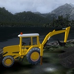
A development jobsite on the island of Haida Gwaii and situated in the Moresby inlet, this is a construction zone and work is going on. There are animated construction vehicles at the job site. The jetty is being updated for future development and the floatplane and boat dock are essential for delivery of the supplies needed for this ongoing construction work site. The water access to the park and the surrounding inlets and islands is key to the transportation in the region. The area roads are maintained by a local timber company but many times the roads are closed due to weather.
WaveTop VFR Plan
From: Sandspit, BC (VZP)
To: Moresby Camp
-
NOTAM: Set Weather and Time from Misty's Place, also go to the Map Room to see a rough flight plan of this flight.
Overview: If you are in a hurry, there is a direct flight plan on the site. But we will do a little zigging and zagging to take in some of the sites on beautiful Moresby Island, one of the two big islands that make up the Queen Charlotte Islands (of which there are many!)
Course: We take off from Sandspit, BC (VZP) and set a heading of 268 taking us initially out over the Hecate Strait. As we turn down the coast, we are in the Skidgate Inlet. We will be following the coast line for about 10 miles. Keep the coast off your port side a mile or more off shore.
-
Alliford Bay comes up to port. Alliford Bay is the Moresby Island terminus of the important inter-island ferry between Alliford Bay and Skidegate Landing on Graham Island.
-
The route is served by the M.V. Kwuna, a small ferry built in 1975, that shuttles between the two main islands of Haida Gwaii several times a day, carrying passengers and vehicles on the 20-minute ferry ride.
-
Alliford Bay also serves as a seaplane base for flights to remote communities, lakes, inlets and parks on the islands. Anglers flying from Vancouver to Sandspit are bussed to Alliford Bay for floatplane flights to the fishing lodges deep in the wilderness frontiers of Langara Island, Kano Inlet, Naden Harbour, and other world-class fishing areas of the islands that are not accessible by road.
-
Alliford Bay was originally built as a Royal Canadian Air Force (RCAF) seaplane air base, operating during World War ll. The base was shut down after the war, and the community of Alliford Bay gradually evolved into a logging center. Alliford Bay is named after Able Seaman William Alliford of the Royal Navy vessel Beaver, which surveyed the bay in 1866.
COURSE: After Alliford Bay, your next waypoint will be some islands coming up to starboard. When those islands are at 3 o'clock, turn 90 degrees to port (you'll see a small cove there) to a heading of 102 degrees heading toward Skidgate Lake.
COURSE: Skidgate Lake will narrow, at it's narrowest point, turn to starboard behind a ridge that is there to a heading of 201 degrees. Ahead you will see another lake. When centered over it you will be turning about 90 degrees to starboard lining up on the landing zone.
- NOTAM: Turn off AutoPilot and assume landing configuration, flaps, reduced speed and altitude of 500 feet.
COURSE: Over the lake, turn to a heading of 250, your destination is on the far shore.
Welcome to Moresby Camp!
Doug Linn
Charter Manager
Misty Moorings, Inc
contact@mistymoorings.com