
Destination: Tremadoc Lake Cabin
Route Notes
- This Scenery is for Return to Misty Moorings only.
- Minimum Altitude: 1200 (2200 at end - see NOTAM)
- Landing zone is: Water, does not freeze
- GPS for destination: N52 41.31 W127 49.45 Alt 1757
- Print-Able copy HERE
- Flight Seeing Plan available HERE
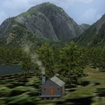
Lake Tremadoc Cabin
Sunrise came late this morning. The sky was clear but the path to our destination was deep inside the Kynock Fjord. Flanked by soaring walls of granite that give no quarter, the air was cool, the scenery fantastic. On the way in, Nina spotted a couple of wolves patrolling the shoreline and I banked over to get a better view. They never broke stride as we approached and only shot us a passing glance as we flew over them. They've seen those loud flying things before. Then a few miles afterwards, there wandering amongst the shrubbery was one of the largest black bears that we've ever seen. It looked huge even from 700 feet above. Not as confident as the wolves, the bear made a hasty retreat into a tall stand of Douglas Fir as we flew by. Soon the sun reached above the eastern ridges and as we turned north towards the cabin, we saw several campers below on Kayaks making their way north. The changing light, amazing terrain and the scenic wonder of this place always leave me surprised. All this and more await to be explored here in the Fjordland Conservancy area.
As you make the trip to this secluded cabin, be sure to take in the surrounding scenery. It's not to be missed. The Fjordland Conservancy, is a huge protected wilderness area located approximately 60 miles (100 km) north of Bella Coola by air. Amazing terrain greets visitors to this world of inlets, islands, rivers, bays and fjords. Scores of waterfalls and glaciers are found here as well. Mountain ranges here vary from old growth forest to bare granite peaks. Camping and hiking are popular here along with wildlife-viewing opportunities. Populations of deer, salmon, and grizzlies thrive in this magnificent area.
WaveTop VFR Plan
From: Bella Bella, BC (CYJQ)
To: Lake Tremadoc Cabin
-
NOTAM: Set Weather and Time from Misty's Place, also go to the Map Room to see a rough flight plan of this flight.
Overview: You will be flying up the Fisher Channel for about 25 miles, and easy, beautiful trip. You will then turn into a narrow inlet that eventually leads you to Tremadoc Lake and your destination. You can fly this safely at 1200 feet until the very last 2 miles of the journey ... there you will increase your altitude to 2200 feet and prepare to land. (A NOTAM is set to remind you of this).
COURSE: We start in Bella Bella, BC (CYJQ) After liftoff set a heading of about 90 degrees. We are heading for the Fisher Channel that is 6 miles ahead. We are taking off from Denny Island.
-
Denny Island: Wonderfully remote in the heart of the Great Bear Rainforest, Denny Island is located approximately 100 nautical miles north of Port Hardy on Vancouver Island and 76 nautical miles west of Bella Coola. It is a mere 2 nautical miles from Bella Bella which is located on neighboring Campbell Island.
-
Denny Island is accessible by plane or by water and can also be accessed by BC Ferries year-round. BC Ferries has direct sailings to Denny Island through the winter months as part of their Inside Passage route. The Discovery Coast Passage route also operates between June and September with stops at Port Hardy, Bella Coola, Bella Bella (McLaughlin Bay) Denny Island, Klemtu and Ocean Falls. A passenger transportation service is available between Campbell Island and Denny Island.
-
The Royal Canadian Air Force chose the Shearwater Marine site on Denny Island as a reconnaissance base during World War II. The base was built to accommodate over 2,000 military personnel, although there were never more than 1,000 stationed there at any one time. This vibrant community is now home to about 70 year-round residents.
-
Services available on Denny Island include a grocery store, liquor store, post office, laundromat, public showers, cappuccino bar and art gallery/gift shop, hair salon, marina, shipyard, marine/hardware store, fuel dock, restaurant, pub, camp ground and RV park, rental cabins, bed and breakfasts, a resort and a hotel. There is also a 70-ton travel lift, a 100-ton haul-out, and a facility for all marine repairs. Denny Island also has a 3000' paved landing strip (see also Regional District services) and a protected float base. Aviation fuel is available at the Shearwater Marine fuel dock. School District 49 (Central Coast) provides classes from kindergarten to grade 8.
-
The area is home to coastal wolves, grizzly and black bears, eagles and the Kermode “Spirit” bear. It is a wilderness destination offering kayaking, wildlife viewing, bird watching, diving, cruising and some of the best sport fishing on the central coast. Sightseeing and eco-tours, boat rentals and fishing charters are available.
-
The community receives reliable hydro electric power from nearby Ocean Falls. (you will pass near Ocean Falls on this journey).
COURSE: Over the Fisher Channel, turn to port to a heading of 360/0 ... but altering heading to follow the channel for 23 miles.
COURSE: You will come to a "Y" intersection 6 miles ahead. The smaller channel going to 11 o'clock leads up to Ocean Falls. We will be turning to port to continue following the Fisher Channel. We have 13 miles to go before our next turn.
- You will see an inlet come up on your starboard side that goes 90 degrees away from the channel. At this point you are 8 miles from you next turn. Continue to follow the channel.
COURSE: The channel ahead of you bends to starboard then back to port. You will be flying around that point of land on the port side and turning into a narrow inlet. (This will be the next inlet you see to port). (Heading about 290).
COURSE: The inlet comes to an end. Continue flying up the valley ahead .. altering heading with the curve of the valley. There are some narrow passages ahead, be careful
COURSE: You will come again to water. A channel comes in from port and turns to go straight ahead of you. Do not turn, fly this channel straight ahead.
COURSE: This channel soon ends and you will be flying over a river. Follow the river between the mountains, adjusting course as necessary.
-
NOTAM: ALTITUDE CHANGE. Minimum 2200 feet! Look ahead and you will see a low peak ahead of you as the river ends. You will be flying OVER that peak maintaining your course. Your landing zone is 2.5 miles ahead.
COURSE: As you see Lake Tremadoc ahead, assume landing configuration, land near the near shore. The Lake Tremadoc Cabin will be on the near shore to starboard.
Welcome to Lake Tremadoc Cabin.
Doug Linn
Charter Manager
Misty Moorings, Inc
contact@mistymoorings.com