
Destination: USFS Hugh Smith Lake Cabin

Route Notes
- This Scenery is for Return to Misty Moorings only.
- Minimum Altitude: 1200 feet
- Landing zone is: Water, does not freeze in winter
- GPS for destination:
- Print-Able copy HERE
USFS Description of the Hugh Smith Lake Cabin
WaveTop VFR Plan
FROM: Misty's Place
TO: Hugh Smith Lake Cabin
Our trip to the Hugh Smith Lake Cabin starts at Misty's Place, PF20.
OVERVIEW: On our journey, we will be flying across Annette Island (rather than around it). We will be flying over Purple Lake, almost the width of the island. (A great shortcut to know flying from PANT to the Revillagigedo Channel. We'll then fly out to Mary Island in the Revillagigedo Channel and make a low pass at the little Mary Island Lighthouse. From there we'll fly to ...
COURSE: We start at Misty's Place .. line up on Rwy 17 (near the white cottage). On liftoff, turn sharply to port, flying over the little lighthouse at Misty Point and then straight ahead flying the length of Bostwick Inlet toward Nichols Passage.
COURSE: Stay to the starboard side of Bostwick Inlet and head for the point there called Seal Cove Rocks.
COURSE: Over Seal Cove Rocks, set a heading of 121 heading toward Annette Island. You will be flying just to the starboard side of the mountain range you see ahead. Our next waypoint will be an inlet coming from the south side of the island called Tamgass Harbor.
On this heading you will fly across Nichols Passage toward Smuggler's Cove. You will fly over tiny Gull Island (with a white navigational light) just off the coast. Notice how unusually flat Annette Island is on its western side ... a perfect place for an airport. An as we approach, you'll see the Annette Island Airport (PANT) ahead to starboard.
COURSE: You will pass over a small hill of land called Yellow Hill and you'll see the shoreline of the Tomgass Inlet ahead. When you reach the shoreline of that inlet, turn to port between the mountains. Agassiz Mountain will be to starboard. Your heading between the mountains should be roughly 60 degrees.
COURSE: You will see Purple Lake ahead. This is a long curving lake. Follow the course of the lake. Toward the end of the lake, it curves sharply to port .. follow the lake. Then be ready for a sharp turn to starboard as you go over Purple Lake Dam and the lake ends. Follow the valley as it leads you to the Revillagigedo Channel ahead.
COURSE: When you clear the shoreline of Annette Island, fly straight ahead (about 70 degrees) to the north shore of Mary Island (7 miles ahead). Set altitude at 200 feet for your pass.
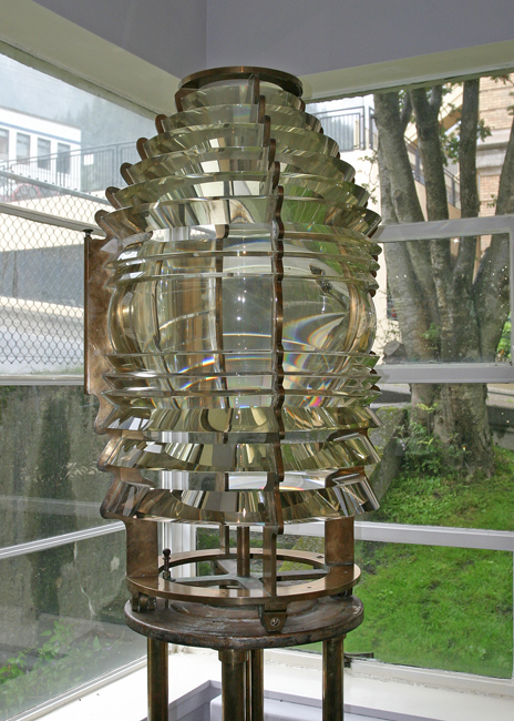
- The Mary Island Light: The lighthouse was named for Admiral John A. Winslow’s daughter, who cruised past the island with her father in 1872 aboard the U.S.S. Sarnac. The U.S. Government later established a customs house on the island in 1891, making it the first stopping place for those sailing into Alaska from Canada. At that time, little attention had been given to marking Alaska’s coastline, as the amount of commerce in the area didn’t justify the necessary outlay. The Lighthouse Board therefore proposed that the customs employees maintain a “small, inexpensive light” on Mary Island, reasoning that the light could be maintained at an annual cost of $800. Congress failed to act on the recommendation, and so it wasn’t until the Klondike gold rush of 1897-98 created a dramatic spike in maritime traffic that serious attention was given to providing aids to navigation for Alaska.
- After the wooden lighthouse had been in service for just over thirty years, the Coast Guard decided that a sturdier structure was required. A new lighthouse was thus constructed on the point between 1936 and 1938 at a cost of $54,792. Built of reinforced concrete in an art deco style, the new tower was square and displayed the light at a height of 76 feet above the water. The base of the tower connected to a flat-roofed building, which housed air compressors and electric generators on its main floor, and fuel, supplies and a heating plant in its basement.
- In 2005, the Fresnel Lens from the Mary Island Lighthouse was on display as part of a shipwreck exhibit at the Juneau-Douglas Museum. While the lens appears to be in great condition, the lighthouse on Mary Island is showing signs of neglect. The lack of outbuildings and difficulty of landing at Mary Island, coupled with its remoteness, are all obstacles that must be overcome by anyone who decides to inherit the lighthouse. Hopefully, an ambitious individual or organization will step forward and keep the lighthouse proudly standing watch over the southern entrance to Ketchikan, Alaska’s first city.
COURSE: As you approach Mary Island, fly at about 200 feet to get a good view of the lighthouse. It will be located on the far side of the northern tip of the island ... watch for its flashing light as your next waypoint. To approach the light, you should be centered between "Mary I Anchorage" and "Customhouse Cove".

COURSE: At the Mary Island Lighthouse, set a course of 78 degrees for about 7 miles to "Boca de Quadra." Increase altitude to 800 feet.
-
You are crossing the Revillagigedo Channel. As you approach this area from the south, long before arriving, Alaska extends you the deep blue carpet of its pristine waters, welcoming you with this Spanish name. It is the long water passage where the Alaska Marine Highway begins at the southeastern corner of the state and takes you almost all the way to Ketchikan, the first town of any size. Regular ships use this channel as one of the numerous water passages forming the system of the marine highways along the coast for their calmer waters. The name was bestowed upon the channel by the Jacinto Caamaño's expedition of 1792. George Vancouver's map not only respected this Spanish name, but added a few more of his own.
COURSE: Watch for the Slate Islands coming up near to port. On the shore ahead, you will see North Quadra Mountain and South Quadra Mountain. Fly over Quadra Point and between the mountains into Boca de Quadra (Mouth of the Quadra).
COURSE: Over Quadra Point, begin following the curvature of the channel, it will bear slight to port.
COURSE: At Orca Point, the "Boca" turns sharply to starboard, follow it, (heading about 115). In about 3 miles, Kite Island will appear ahead, over Kite Island, turn sharply to port, (heading about 55).
COURSE: Fly over the shoreline ahead at Sockeye Creek (a low spot in the crest just ahead). Beyond the crest you will begin to see Hugh Smith Lake.
COURSE: Over the lake, get to landing altitude and configuration. The lake will curve to port ... follow the curvature. The Hugh Smith Lake Hatchery will be straight ahead near Buschmann Creek on the starboard shoreline.
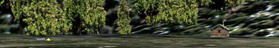
Welcome to Hugh Smith Lake Cabin.
Doug Linn
Charter Manager
Misty Moorings, Inc
contact@mistymoorings.com