DISPATCHER'S | C A M B R I A ... I C E F I E L D...R E S E A R C H...P R O J E C T |
|
|
| RIBBON |
B R I E F I N G |
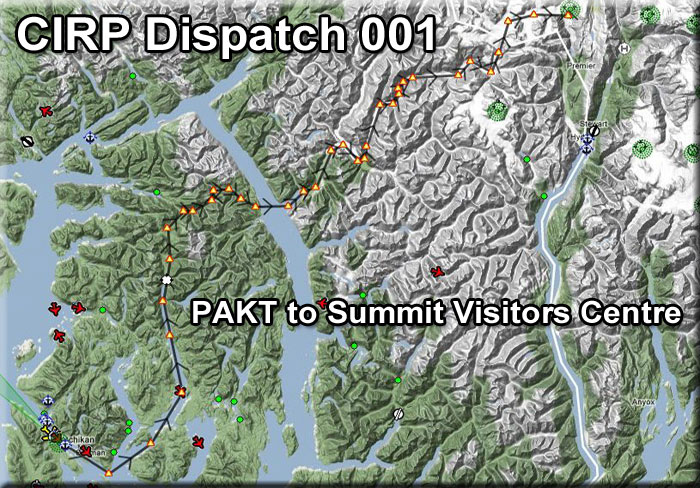
1 Start at PAKT Link to Brochure |
This is "The Glacier Tour" and is recommended as the "starting" flight for all of the CIRP dispatches. Imagine you are a visitor to Ketchikan and at the kiosk on the corner, you see a brochure entitled "Glacier Tours - The CIRP Project". You pick it up, read it, and decided this is a side trip you want to make. I you are are a new pilot to CIRP, then you should download this explanation of CIRP and what you will encounter in the glaciers. The glaciers you will be visiting are high above the Stewart, BC area. This dispatch takes you from PAKT to one of the 10 Ice Stations in CIRP, the Summit Ice Station. Here you will find a visitor's center with all the amenities. Taking this flight gives someone new to CIRP a feel for the change of topography and the vastness of what they are about to encounter. Your adventure starts at PAKT, the flight plan is "autopilot friendly" so you can set the autopilot and sit back and enjoy the beautiful scenery that awaits you. You may fly at 1200 feet until you begin approaching the glaciers, at which point you will have to climb quickly. Set your ADF to 248 (Summit Ice Station) and you are on your way. Welcome to CIRP ! |
| 2 Waypoint GT001 ------ Direct Heading: 102 Distance: 7.4 miles |
After taking off from PAKT, set your altitude for 1200 feet, turn on the autopilot if you are so inclined. Ketchikan will pass by to port and you will fly over the center of Pennock Island. When the Carroll Inlet comes to port, turn into the inlet on a bearing of 30 degrees for 5.4 miles this is Waypoint GT001. |
| 3 Waypoint GT002 ------ Direct Heading: 030 Distance: 5.4 miles |
On your way to Waypoint GT002, you will first pass Herring Bay where you will see the harbor with the cannery. Another couple of miles up the inlet and you will see Nina's Landing, an exclusive resort in the area. The Carroll Inlet splits off to Starboard (the George Inlet is the channel veering off to port). Follow the starboard channel to Waypoint GT003 where the channel turns to point.. |
| 4 Waypoint GT003 ------ Direct Heading: 008 Distance: 7.0 miles |
Waypoint 003 is where the Carroll Inlet turns gently to port. Set a heading of 008 degrees for 7 miles following the Carroll Inlet. You will fly directly over Brunn Point. Split Point passes close to starboard and little Hume Island passes beneath the port wing. Osten Island, in the center of the Carroll Inlet passes just under the starboard wing. When Island Point comes up to port, the inlet turns to port again. This is Waypoint GT003. |
| 5 To Waypoint GT004 ------ Direct Heading: 326 Distance: 11.0 miles |
At GT003, turn to 326 degrees for 11 miles following the Carroll Inlet toward Waypoint GT004. Along the way, Marble Creek will show up on the starboard shore. Two miles further, the two Saddle Lakes will be seen off the port wing. Shelter Cove will past to port and you will begin to see the power lines on the port shore. Continue to fly the center of the Carroll Inlet as it narrows. Watch for Falls Creek to starboard, that will be Waypoint GT005. |
| 6 Waypoint GT005 ------ Direct Heading: 349 Distance: 5 miles |
At Waypoint GT005, make a slight course correction to 349 for 5 miles. You are heading to the end of the Carroll Inlet. At the end, you will pass over Lucky Lindey's Place, a notorious landmark in this area. Continue overland on this same heading. After Lucky Lindey's, look for a gap in the mountains ahead and to port. As you approach this, you are at Waypoint GT008. (Waypoint GT007 has been eliminated). |
| 7 Waypoint GT006 ------ Direct Heading: 334 Distance: 4 miles |
At Waypoint GT006, turn a little to port to 334 and fly through the gap in the mountains and on up the valley ahead for 4 miles. As you near the mountains you are at Waypoint GT007. |
| 8 Waypoint GT007 ------ Direct Heading: 024 Distance: 3 miles |
At Waypoint GT007, you turn to starboard to 024 for 3 miles. You are continuing to fly up a valley, in 3 miles the valley turns to starboard at GT008. |
| 9 Waypoint GT008, 009, 010 ------ Direct Heading: 004 Distance: 3.5 miles |
At Waypoint GT008, turn to starboard to 070 and follow the valley to GT009 and GT010 as the valley turns to port. Follow the course of the river below. Where the valley turns sharply to port is GT010. |
| 10 Waypoints GT010-011 ------ Direct Heading: 061 Distance: 2 miles |
At Waypoint GT010, you will turn sharply to port then be ready to turn quickly to starboard at GT011. At GT011, the valley splits with the river going off to port, follow the starboard valley flying over the small lake there. Spotted Lake shows up and this is Waypoint GT012. |
| 11 Waypoint GT012-013 ------ Direct Heading: 103 Distance: 3.6 miles |
Over Spotted Lake (Waypoint GT012) turn to a heading of 103 for 4 miles flying to the end of the valley. When the valley opens up, and you can see water ahead, you are at Waypoint GT013. Continue to the water's edge ahead which is Waypoint GT014. |
| 12 Waypoint GT014 ------ Direct Heading: 066 Distance: 3.5 Miles |
At Waypoint GT014, you are heading out over the Behm Canal. You will see an inlet across the canal, fly toward the center of that inlet. About 8 miles to starboard down the canal is the famous Eddystone Rock. If you have time and the weather is good, that is a nice side trip. The inlet ahead is the outfall of the Chickamin River (coming from the Chickamin Glacier). The port-side point is called Fish Point and the starboard-side point is Trapp Point ... fly between these up "The Flats" of the Chickamin River. The entrance to the Chickamin River is Waypoint GT015. |
| 13 Waypoint GT015 - GT020 ------ Direct Heading: 018 Distance: 10 Miles |
At GT015, set a heading of about 018 degrees. You will be flying up the Chickamin River flats. You will pass Choca Creek coming from starboard. Continue following the flats as they curve left and right. The flats "split" port and starboard ahead. You will be taking the starboard turn, this is the basin of the Luduc which we are going to follow. When you turn to starboard up the Luduc, you are at Waypoint GT020. |
| 14 Waypoint GT020 ------ Direct Heading: 115 Distance: 3 miles |
At GT020, you turn to starboard up the Luduc River Basin on a heading of 115. You will follow this only for 3 miles before you turn sharply to port. (Notice how the topology is changing, broad flat basins that were the cradles for glaciers born long ago ... and the mountains are rising and becoming sharper). Watch carefully to port. You will see a narrow gap in the mountains there where Barrier Creek flows into the Luduc. We will turn sharply to port here. |
| 15 Waypoints GT020, 021 ------ Direct Heading: 354 Distance: 2 miles |
As you turn into the gap at Barrier Creek, you are crossing over Waypoints GT020 and GT021. As you come out of the turn, you will see the valley ahead, when you are safely in the center of that valley, you are at GT022. |
| 16 waypoint GT022-029 ------ Direct Heading: 023 Distance: 17 miles |
Once in the valley, you will be following this as it gently curves left and right for about 17 miles to waypoint GT029. You are following the south fork of the Chickamin River. This, of course comes from the Chickamin Glacier about 20 miles ahead. Chickamin Glacier is on the eastern slopes of Dome Peak (2,723 m). This composite valley glacier and slope glacier demonstrates the variations that can take place even in a single ice mass. The tongue has retreated since observations began in 1955, but the terminus on steep cliffs on the right advanced rapidly in the early 1950's and has remained little changed since then. With their own time clocks, these glaciers are alive and in motion ... and that is what the Cambria Icefield Research Project is studying. |
| 16 Waypoint GT029 ------ Direct Heading: 095 Distance: 2 miles |
NOTAM: Turn off Autopilot, climb to 5500 feet . You will be flying over the tongue of the glacier and then up its slope to the beautiful glacier areas where the CIRP studies are taking place. Continue climbing and following the glacier as it curves sharply to port. |
| 17 Waypoint GT030 ------ Direct Heading: 353 Distance: 4.0 |
When the tongue of the glacier turns sharply to port, you are at Waypoint GT030. Fly a heading of 353 continuing to climb staying above the glacier. You will see a glacial slope to port, go straight ahead, continue climbing. There will be 3 sharp peaked mountains ahead of you, fly to the right (starboard) of them. When the mountains are off your port wing, look to starboard for a glacier sloping down. You are at Waypoint GT030. |
| 18 Waypoint GT031, 032 ------ Direct Heading: 054 Distance: 6.7 |
At GT031, turn to 054 and follow the glacier. You may begin decent to follow the slope of the glacier. As you near the end of it and mountains are ahead, fly to the starboard side of the glacier and set up landing configuration. Your destination's runway is 34/16. Watch the ADF (NDB 248) which will guide you to the area of the runway. Approach the NDB on a heading of 340 and you will be lined up on the runway. |
| Summit Ice Station PF48 ------ |
Welcome to Summit Ice Station. Here you will pull up to a Visitors' Center where you will be met by a guide that will take you through the features of the glacier museum, get you acquainted with the instruments used on the glaciers and give you a tour of the building. The coffee in the coffee shop is always hot and strong. Enjoy your visit to the top of our world at CIRP. |
|