DISPATCHER'S | C A M B R I A ... I C E F I E L D...R E S E A R C H...P R O J E C T |
|
|
| RIBBON |
B R I E F I N G |
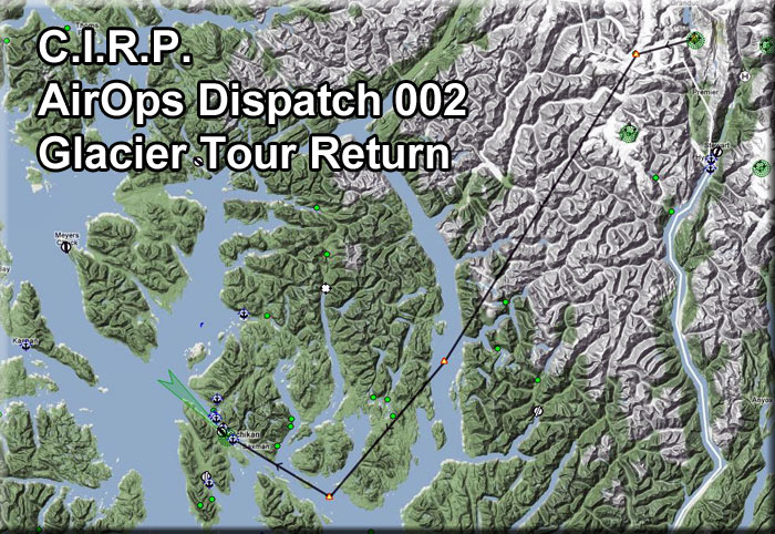
1 Summit Ice Station to Turn 1 |
This is the RETURN trip for the Glacier Tour that originated at Ketchikan Airport. The visitors now have seen the Visitors' Centre, been given a hovercraft ride out on the ice, a bus tour of the glacier and a tour of the working areas of the Summit Ice Station. The visitors are literally worn out, what a long day. Now they are slowly walking out to your aircraft for the ride back to Ketchikan. You gave them the "low and slow" tour on the way here. On the way back, you are going high to give them a feeling of the immensity of this entire area. We'll leave from Summit Ice Station, fly up the glacier that faces the Visitors' Center, then gain some altitude and make a direct heading for the approach to PAKT. Set your autopilot for 7000 feet in altitude at a 700 fpm rate. This takes you to Turn 1. (Be at 5500 feet at Turn 1). |
| 2 New Eddystone Rock ------ Direct Heading: 194 Distance: 50 miles |
At Turn 1, you are heading directly toward New Eddystone Rock on a heading of 190 for 42 miles. Just after you make the turn, point out to your visitors that we are flying over the Chic kaman Glacier Basin that we flew up on our way to the Glaciers. They will get a view of the route from a much higher vantage point. Follow 190 to New Eddystone Rock, 42 miles ahead. As you approach New Eddystone Rock, give the visitors the following story (and if the weather is good, drop down lower to see "the rock"): The Alaskan island called New Eddystone Rock is a pillar of basalt. Sometime during the last 5 million years, the basalt came from fractures in the floor of Behm Canal. The broken, haphazard texture of these basalts indicates that New Eddystone Rock was part of a volcanic vent where magma rose repeatedly to the surface of the earth.
NOTAM: This route allows for bad weather ... you can fly above the weather until the Ketchikan Approach waypoint where you can safely come down through the weather lining up for Ketchikan. If it is a clear day, you may want to fly direct to Ketchikan which is on a heading of 207 for 71 miles. NOTAM: Approaching New Eddystone Rock, you can set your autopilot altitude at 4000. |
3 Ketchikan Approach |
At The Ketchikan Approach waypoint, you can begin lowering altitude to 1200 feet ... PAKT is 20 miles ahead so adjust your decent accordingly. Other than other air traffic, you are safe to descend in this area because you are over water. Contact PAKT and make a normal approach. Thank the visitors for spending the day with CIRP and ask them to tell their friends about the trip so others can experience a day on the glaciers. |
4 Ketchikan Airport |
Welcome your visitors back to Ketchikan International Airport. Tell them you hope they had a once-in-a-lifetime experience by spending a day on the glaciers above Stewart and learning how an ice station like Summit Ice Station operates. Tell them to share their pictures with friends and encourage their friends to take the trip also. Hand out the business cards, say "good bye" and tie down the plane for the evening. |
|