DISPATCHER'S | C A M B R I A ... I C E F I E L D...R E S E A R C H...P R O J E C T |
|
|
| RIBBON |
B R I E F I N G |
Helicopter Dispatch 001 Erickson Ice Station, Dispatch Office |
It is 8:00 am and a very cold morning on the Cambria Icefields. Sometimes you wonder why you have chosen this area of the world as my "home" ... but then I look out the window and remember. Nothing in this world compares with the stark yet dangerous beauty of the icefields. Both keep me here, the beauty and the danger. Few pilots have the skills to fly the regular routes of CIRP with the treacherous weather encountered daily. Today's dispatch is far from routine. You are flying with skilled helo co-pilot but one that has never flown the icefields. You are introducing him to CIRP and personally, you want him to love this area and this job as much as you do. So your goal is twofold, the company goal of acquainting him with the icefield helicopter operations and to get him to want to become an important part of this project. |
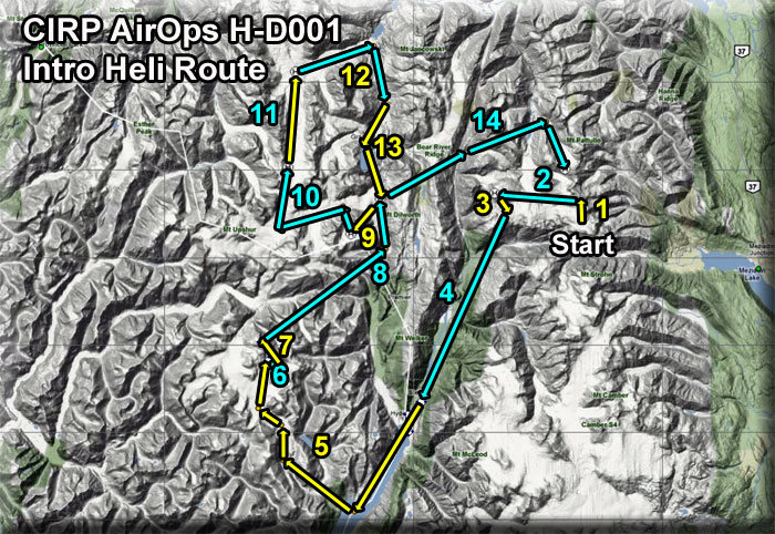
Leg 1: From Erickson to Big Mountain Helitower |
You have met your new co-pilot, have shared a great cup of coffee. You've filled up the Thermos with more coffee for later and gone over the day's flight with the new co-pilot. Out on the pad, you pick up two maintenance workers, load their equipment and fly from Erickson Ice Station to Big Mountain Helitower only 1 mile from here. If you look to the north, you can see your first destination on top of the little mountain there. The Altitude here at Erickson Ice Station is 6087. The altitude at the Mountain Helitower is 7720 feet. You fly this first leg so your new co-pilot can begin to "feel" what it is like flying a copter in these hazardous conditions. |
| Leg 2: Big Mountain Helitower to Mt. Johnson Mountaintop Helipad ------ Direct Heading: 257 Distance: 5.9 nm |
After landing at the Big Mountain Helitower, you unload the equipment. With your skilled hand nearby, you turn the controls over to the new co-pilot just to let him get a "feel" for the turbulence and handling of the copter in these high altitude and extremely cold conditions. You are now flying a heading of 257 for 5.9 miles to the Mt Johnson Mountaintop Helipad, it is at an altitude of 7172 feet.. Here, you drop off the two maintenance workers who are going to continue work on a solar panel for the helipad. |
| Leg 3: Mt Johnson Mountaintop Helipad to Mt. Johnson Ice Station (PF45) ------ Direct Heading: 114 Distance: 1.4 nm |
We fly from the Mt Johnson Mountaintop Helipad on a heading of 114 for a short flight to the Mt Johnson Ice Station and land on the helipad there. Set your ADF to 245 for Mt. Johnson NDB. Two of the scientists there just completed their first tour of duty on the ice and want to travel to Ketchikan. After a long tour on the ice, and rough housing conditions, a warm fireplace and a soft bed in Ketchikan will be a nice change! And the beer in Ketchikan is plentiful! |
| Leg 4: Mt. Johnson Ice Station (PF45) to Stewart CIRP Ops Center ------ Direct Heading: 182 Distance: 14 nm |
You take off on a heading of 182, clearing the 5000 foot peak to the south of Mt Johnson Ice Station. Once past that peak, you are safe to begin descending to sea level being careful for mountain ridges on this 14 mile journey. When you sea the Bear River basin below, you can safely go down to 1200 feet and fly the basin to Stewart. The basin runs on a heading of about 177 to Stewart. You will be parallel to the Stewart Highway most of the way to the airport. With the weary scientists, we now leave Mt Johnson (PF45) on a heading of 182 for 14 miles arriving at the CIRP Ops Center at Stewart (CZST). We land on the pad there and drop off the scientists and their baggage. They will fly to Ketchikan (PAKT) in a regular shuttle CIRP runs between Stewart and Ketchikan. |
| Leg 5: CIRP Ops Center to Through Research Center (PF49) ------ Direct Heading: 249 Distance: 27 nm |
At the Ops Center, we pick up new cargo and take off. Our next destination is the Through Glacier Research Station (PF49). Rather than flying direct, we fly on a heading of 187 for 9 miles down the Portland Canal. At our turn, you will see Soule Landing. There we turn to starboard to a heading of 285 for 6 nm using the NDB frequency of 249 (PF49). Fly up the valley created by the Soule Glacier and following the valley. Using the preset waypoints in the GPS, you will fly over the Soule Glacier and be gaining altitude. Climb to 4500 feet. Land on the helipad at Through (PF49). NOTAM: Through Research Center is at 4480 feet. |
| Leg 6: From Through Glacier (PF49) to Through Radar Station ------ Direct Heading: 086 Distance: 1 nm |
There is a problem up on the radar station above Through Research Center. The station has been down for 2 days while the maintenance people there have been patiently waiting for a break in the weather so they could get the equipment we are bringing to them. There is a small wooden helipad up there. The altitude of the helipad is 6132 feet, so this flight will be more vertical than horizontal. The station is located 1 nm away on a heading of 086. After landing, we drop off the much-needed equipment and prepare for the next leg of the flight. |
| Leg 7: From Through Radar Station to Through "Party" Site ------ Direct Heading: 304 Distance: 2 nm |
We leave the Through Radar Station on a heading of 304. the altitude at the next helipad is 6400 feet so we will maintain altitude. The helipad is only 2 miles in distance. The Through Glacier scientists and workers are having their annual party today (they have this about every 3 weeks!). They camp in this area and walk from the campsite up to the mountaintop station. You come down to do a quick low flyover the fire because you know the lady cooking the hot dogs is one of the prettiest scientists in the group, maybe you'll get to see her again. She recognizes your helicopter as you fly over and waves. (That's a good sign!). So you drop down to the helipad there and have a nice chat with her introducing your new co-pilot. You then fly to the helipad on the neighboring mountain and land to drop off "party" supplies ... they ran out of beer! We now prepare for Leg 8 of this trip. |
| Leg 8: Party Site to Summit Ice Station (PF48) ------ Direct Heading: 018 Distance: 12.8 nm |
Although we could fly direct on a heading of 018 for 12.8 nm, we decide to fly on a heading of 031 for 9 miles so we can fly up the Salmon Glacier to land at Summit Ice Station. At 10.7 nm, we make a turn to 326 for 4 miles following the ADF to the 248 NDB frequency for Summit Ice Station (PF48). You can stay at altitude until you see Salmon Glacier below, then begin descending to Summit Ice Station at 2915 feet of altitude. We land at the helipad there. This station is partially designed for tourists from Ketchikan, so they can see how a real ice station operates. Since the tour of the station is just starting, you drop off your co-pilot with the tour guide at the Visitors' Centre and head over to the cafeteria for a cup of coffee. When the tour is over, you meet at the helipad and prepare for Leg 9. |
| Leg 9: Summit Ice Station to Summit Research Outpost ------ Direct Heading: 198 Distance: 2.4 nm |
This Ice Station supports many "glacier instruments" that have been placed in remote locations. One of our jobs is to drop off these instruments to teams out on the ice who will install these while giving us broken ones to bring back. We load up the equipment and head for Summit Research Outpost, 2.4 miles away on a heading of 198, but there is a mountain between here and there. So it is best to fly up the glacier on a heading of 240 until you see Lindeborg Glacier coming in from port, then turn there to a heading of 135. 2 miles ahead you will see the tents and the improvised landing zone there (cones). We land there, drop off the equipment and start Leg 10.. |
| Leg 10: Summit Research Outpost to Instrument Repair Team Camp ------ Direct Heading: 296 Distance: 6.5 nm |
We take off from the Research Outpost and fly down Lindeborg Glacier on a heading of 327 for 2.2 miles. Then we turn sharply to port to a new heading of 227 for five miles flying up the glacier. The Frank Mackie glacier will come in from starboard, our next waypoint makes a turn to starboard to 349 for 4.4 miles. We look for an encampment where the glacier instrument repair team as their camp. They have also made an improvised landing zone with the cones. You introduce the new co-pilot to one of your best friends who is working at this camp and share a cup of coffee. We hand off the new equipment, and take aboard the equipment that is broken. We say goodbye to my friend and climb aboard the helicopter for the next leg of the today's trip. |
| Leg 11: Instrument Camp to Frank Mackie Research Outpost ------ Direct Heading: 346 Distance: 6.3 nm |
Taking off from the Instrument Repair Camp, we fly on a heading of 346 for 6.3 miles up the expansive Frank Mackie Glacier. Our destination is the Frank Mackie Research Outpost. There is a solid helipad at this location. You must be careful of their weather balloon that flies over the camp. While dropping of the supplies, the chief scientist asks you for help. A tourist visiting the outpost was so fascinated with this beautiful place that he missed the departure of his tour bus. He must get back to Summit Ice Station before the return "Glacier Tour Flight" this evening. You are asked to fly him to Summit. You agree, since you have time to take him back and are going that direction anyway. You pick up the passenger and continue your route explaining what you are doing along the way for him. |
| Leg 12: Frank Mackie Research Outpost to the Granduc Mining Camp and Memorial. ------ Direct Heading: 188 Distance: 6.2 nm |
On this leg, we were going to head straight for Summit Ice Station, but since we have the time, we thought we would show the passenger (and the new co-pilot) the Granduc Mining Camp and the memorial there. We fly on a heading from the Frank Mackie research Outpost of 047 for 5 miles to the bottom of the glacier, then turn to starboard to a new heading of 132 for 4.4 nm. This brings us to the Granduc Mining Camp. We have time to land so they can view the memorial and you give them some background on it:
After viewing the memorial, you prepare for the next leg taking you back to Summit Ice Station. |
| Leg 13: Granduc Mining Camp to Summit Ice Station (PF48) ------ Direct Heading: 168 Distance: 6.4 nm |
Leaving the mining camp and the memorial, you now take off and head back to Summit Ice Station. You set 248 on the ADF to head to Summit Ice Station. You begin on a heading of 186 for 3.4 miles, then make a heading correction to port to a new heading of 139 for 3.4 miles. You will pass over Summit Lake which freezes in the winter but is a landing spot for float planes in the summer. There is a small visitors welcoming station there for tourists who arrive by float plane in the summer and then who are transported up to the Visitors' Center in a tour bus. You fly 2 more miles land at Summit Ice Station (PF48). You say good bye to your passenger who insists on tipping you, but of course you cannot accept tips. So you give him your email address and ask him to send you the pictures he took at the memorial, he says he will. |
| Leg 14: Summit Ice Station to Mt Pattullo Ice Station. ------ Direct Heading: 054 Distance: 13 nm |
We leave Summit Ice station and head for Mt. Pattullo Ice Station. We put 246 into the ADF to home in on Pattullo's NDB beacon. We take the "scenic route" flying on a heading of 040 for 6 miles until we are over the Bear River basin, then make a slight correction to starboard to 045 for 6 miles. When we see the Mt Pattullo glacier to starboard, we turn to 136 and follow the glacier for 3.6 miles to abandoned ice station at Mt. Pattullo. From the ice station, the cabin we are seeking is on a heading of 182 from the center of the abandoned ice station. You will see the abandoned ice station, and it is worth a fly-by for your new co-pilot. But your destination is not far from the old ice station. You are heading to a cabin where an old friend of yours actually lives. You have called him on the radio and he's waiting for you on the helipad, waving as usual. He's a history buff and has been studying this area for years ... well, he says that's what he does. But you suspect that he does more "enjoying" than "studying" in the area. The nice thing about having a satellite link, a generator and a computer is you can work from anywhere. And this old friend does much of the day-to-day activity reporting on what is happening on the nearby glaciers. (He even knows about the party they are having over at Through!). You land at his helipad and shut down the helicopter, tying it down for the night. You'll be staying overnight here and enjoying the amazing sunsets of the Cambria Mountain range. Not every one can say they have slept in the shadow of Mt. Pattullo. What a great way to end the day with your new friend and co-pilot. |
|