DISPATCHER'S | C A M B R I A ... I C E F I E L D...R E S E A R C H...P R O J E C T |
|
|
| RIBBON |
B R I E F I N G |
Erickson Glacier Ice Station |
It is a new Morning on the Cambria Icefields. After Breakfast and
Briefing in PF47`s Headquarter Time to go outside. The air is as sharp as a cold knife. You look around at the vast white expanse, even though you are new to this area, every time you see this is is no different than the first time ... simply breathtaking. Your Whirlybird
is already waiting on the Helipad and your experienced instructor pilot is standing beside it, arms crossed and sort of tapping his boot. Uh, he isn´t very amused, waiting for you in the cold while the "newbie pilot" finished his hot coffee! O. K., I know I should work on this! A little more promptness on my part might be in order! Our first load of the day consists of two repairmen, who also are already waiting on the helipad on your arrival. .As you enter the cockpit, these guys remind you of a promise your instructor made the last time they were aboard that he would take an alternative route for them on next ferry flight showing them new sights. OK this is their next ferry flight, time for me to keep a promise. Besides, it is always exciting to vary the route. The challenges of a new route only makes me a better pilot. |
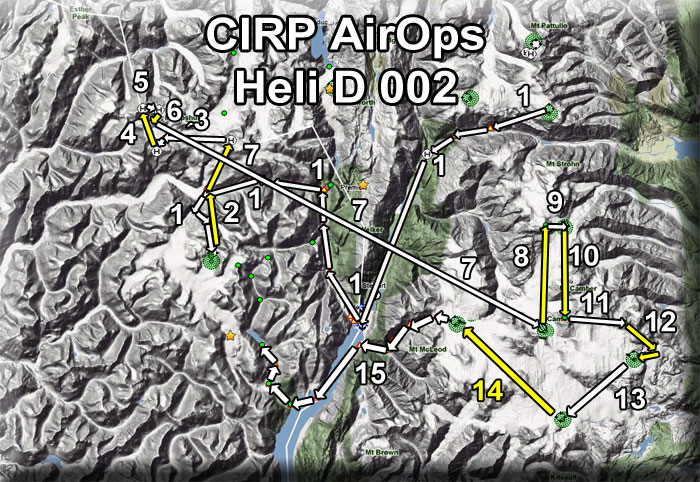
Leg 1 Erickson Glacier Ice Station to Through Glacier Research Ctr |
Take off at Erickson on a heading of 227 for 8 miles, coming over the Bear River Basin. Once over the basin, turn to 180 and fly that heading for 12 miles. You will fly along the route of the Stewart Highway and pass over Stewart, BC airport (CVST). As you pass Hyder to starboard, you turn to starboard and begin flying up the Salmon River Basin on a heading of 307, then turning gently to starboard with the glacier to 330. still following the Salmon River Basin, flying toward the Salmon Glacier.
After 10 nm over this basin, and when the Salmon Glacier appears ahead, you take a hard turn to port and fly along this valley for 8 nm, first on a heading of 257, then the valley turns to port and you come to 233. You come to an intersection of glaciers .. one straight ahead, one coming in from starboard and you turn to port and climb to the summit of the glacier there on a heading of 187 for three miles. You then turn toward Through Glacier Research Station (NDB 249) on a heading of 093. Here you drop off some supplies, then continue to Leg 2. |
Leg 2 Through Glacier Research Ctr to Mt Jeff Coolidge Wx Stn |
You take off from Through Research Center's helipad on a heading of 327 for 4.2 nm. You will again be at the intersections of glaciers. This time, you will go nearly straight ahead (bearing 006) for 3.2 miles to the Mt. Jefferson Coolidge. You land at the weather station there so the repairmen can install a new vhf antenna that was damaged in a recent high-wind storm. It doesn't take them long to fix the problem, you confirm that the antenna is working by calling the Ops Center and they report a strong signal from the weather station. Job finished, onto Leg 3. |
Leg 3 Mt Jef Coolidge Wx Stn to the Jay Overlook Wx Station |
We leave the Jefferson Coolidge Weather Station on a heading of 237 flying a straight course to the next stop which will be the John Jay Overlook Weather Station. This station is situated on the edge of a cliff where high winds can almost always be expected. We land at the helipad at the weather station. Part of the roof has blown off the building housing the radio system, apparently from the same storm. This will take some time to repair but our people have the tools and materials and set about their work. This is always a beautiful place to just look out over the distances below and afar. It makes one feel very small indeed. Once the work is finished, we pack the tools, climb into the helicopter and prepare for Leg 4. |
Leg 4 Jay Overlook Wx Station to John Jay Mountain Wx Stn |
We take off from Joy Overlook and head for John Jay Mountain Weather Station. This is one of the highest weather stations and helipads in the entire CIRP system at 7236 feet, certainly the highest on the Summit side of the project.. This leg is mostly "up". We go from 2937 feet to 7236 feet in 3.1 miles. We do a routine check of the instruments there and the repairmen give me a thumbs up .. all is working. So we prepare for the short hop to the sister weather station on the nearby mountain peak. The reason for these two stations so close together is because the scientists are studying a wind shear phenomenon between these two mountains that affect a buildup of ice at higher altitudes that was not predicted. Studying the difference is wind speeds between these two peaks may give them the answers they are looking for with the data from these two stations. Off to Leg 5. |
Leg 5 John Jay Mountain Wx Stn to John Jay Mtn Wx Stn #2 |
Take of and position to a heading of 080. You will see the second WX station on a nearby peak about 1 mile away. Fly to this second weather station and land. This is a quick stop because the instruments are all working fine according to the telemetry to the ops center, so this check is simply routine. The repairmen will be looking for any storm damage of the antennas and peripheral equipment. While they do this, you pour a cup of coffee from the Thermos Bottle and marvel at the view from this altitude. On a clear day, look to a heading of 250 and you will see the first weather station on top of the John Jay Peak. |
Leg 6 WX Stn #2 to John Jay Camp |
Take off from WX Stn #2 on a heading of 190 and descend to the John Jay Camp about 1 mile away landing at the helipad there. You will be dropping down about 2000 feet on this approach. Here it is time to take a break. You shut down the engine on the heli and are welcomed into the warm tents for coffee and conversation. Since you bring the mail on each of these trips, you are always a welcome visitor! This was the final destination for the two repairmen, so you say goodbye to them, they thank you for the special "sight-seeing" route and you head back to the copter for Leg 7. |
Leg 7 John Jay Camp to Bromley Peak Ice Station (PF43) |
You set your ADF for 243 (Bromley Peak) and take of on a direct heading of 097. This is a longer leg and you go to a minimum safe altitude of 8600 feet. . As you near PF43 (Bromley Ice Station) you lower your altitude to land at the helipad there. The altitude of the helipad is 5120 feet. (see chart). You pick up a special cargo that was delivered here by mistake and load it aboard to take it to Mt Otter Mountaintop Helipad. After this stop, you are ready for Leg 8. |
Leg 8 Bromley Peak Ice Station to Mt Otter Mountaintop Helipad |
You take off from the Bromley Ice Station (PF43). The ADF is set to 241 for Otter Mountain's NDB. When the adf shows the target to be at about 90 degrees, you are nearing your mountaintop helipad. Watch the wind direction and gusts at this level. The helipad is at 8800 feet.
You deliver the cargo and again marvel at the surrounding area ... nothing but snow, ice and mountain peaks as far as you can see. Once the cargo is off loaded, you prepare for Leg 9.
|
Leg 9 Otter Mtn Mountaintop Pad to Otter Mtn Ice Station (PF41) |
With your ADF already set on 241 for Otter Mountain's NDB, you continue your flight by taking off from the helipad with a sharp descent heading 062 for 2 miles. You do a low "fly by" of Otter Mountain Ice Station just to say a quick "hello" to some of your friends who are working there. You then continue flying to complete Leg 10. |
Leg 10 Mt Otter Ice Station to Bromley Peak Mountain top pad. |
Set your ADF to 243 (Bromley Peak) and fly a heading of 156 for 6.2nm to PF43 Mt. Bromley Mountain Top. When your ADF indicates Bromley's NDB is at about 90 degrees, you are near your destination. This helipad is located at 7900 feet. Your task is to check the satelite-tower visually there. If you notice any damage land on the heli-pad and try to repair or note the damage`s subject for ordering replacing equipment. |
Leg 11 Bromley Peak Helipad to Cambria Mountaintop Pad |
Leaving Bromley Peak, fly a heading of 071 for 3.5 miles to the Cambria East #1 Satellite Array Installation. The pad near the antennas is at 7742 feet. Your job here is to get out of the helicopter and make a visual inspection of the antennas making sure the recent high winds have done no damage. You write down any damage you see for your report. |
Leg 12 Cambria Mountaintop Pad to Cambria Ice Station (PF42) |
You set your ADF for 242 to receive the beacon from Cambria East Ice Station's NDB. Leaving the Cambria Mountain installation, you on a heading of 140. Off to port, you notice some activity out on the ice and your instructor pilot asks you to fly over to check out the activity. You can land on the ice there and talk with the scientists. Take off again and fly to the Cambria East Ice Station ... it is on a heading of 253 from the scientists. Follow your ADF to Cambria East and land on the helipad there. (See Chart) One of the scientists is waiting with his luggage. You will be flying him to Rest & Recreation Lodge for a little "R&R" ... he has been up on the ice for 2 months and could use a little well-earned downtime. Load the passenger and his luggage into the aircraft and prepare for Leg 13. |
Leg 13 Cambria E. Ice Station to Kitsault Peak Ice Station |
Set your ADF for 244 to pick up the beacon from Kitsault Peak's NDB. On takeoff, come to a heading of 208 and fly this for a distance of 6 nm to the helipad at Kitsault Peak Ice Station (see chart). . There`s another scientist waiting for ferry flight to R&R Lodge. Pick up passenger, pick up luggage and head to R&R lodge via Mt McLeod Ice Station. |
Leg 14 Kitsault Peak Ice Station to Mt McLeod Ice Station |
We will do a flyover of Mt McLeod. Set your ADF on 240 for the NDB at Mt McLeod. When you see the ice station below, you are ready for Leg 15. |
Leg 15 Mt McLeod Ice Station to Rest & Recreating Lodge |
As you pass Mt McLeod, watch for a sharp valley in the ice to port in about 1 mile distance. You will turn to port to about 215 and follow that steeply descending valley down to the Marmot River basin below.When you arrive at the Marmot River Basin, you will turn sharply to starboard to 285 and follow the river for 2 miles to the Portland Canal. Notam: as you descend this valley, your altitude can go to 1200 feet safely all the way to R&R Lodge. Once over the Portland Canal, you can turn to 203 and fly diagonally across the canal for 6 miles. You will find Soule Landing coming up ahead to starboard. There is a Brad's Bait & BBQ at this location, and if the scientists would like a lunch or dinner (depending on your timing) you can land there or continue up the Soule Glacier Valley on a course of 296. At "Soule Glacier's Half Way Cabin, you will turn a little to starboard to 005, then as the valley curves to port, follow it to No Name Lake which you will see ahead. The helipad is beside the lodge. You drop off the passengers and luggage. You and your instructor have a cabin for the overnight before you fly to the Ops Center at Stewart in the morning. A little "R&R" even if it is only for an evening is good for everyone! |
|