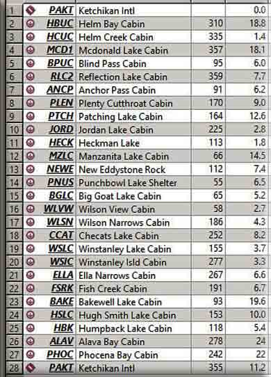
| VFR - USFS1 - Ketchikan Ranger District |
 |
| Written Flight Plan |
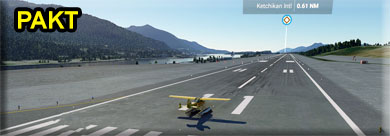
NOTAM: You should download and install the New Eddystone Rock Mod from the Scenery Page. Ketchikan (PAKT Start)
Our dispatch starts at Ketchikan International Airport, (PAKT). The highest terrain during this trip is 3800 feet, so all WayPoints will show 3800 feet. All locations are, in fact, nearly at sea level. You can fly directly to each location if the weather is good and you have sufficient equipment. The "VFR Comments" in the legs below are designed for (more typical) poor weather conditions ... keeping you at about 1200 feet and over water. Remember, in the real world, people have rented these cabins months in advance, they've flown to Alaska and now expect to go to the cabin they are paying for. So the pilots have to fly in less-than-perfect weather conditions often to meet this "hotel schedule-like" demand. You can read about the actual cabin facility in the USFS Cabin Information section for each location. Leg 2 - Helm Bay Cabin
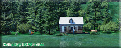
VFR Comments: The safe altitude for this leg is 1200 feet. Leaving PAKT, you will fly to the end of the Tongass Narrows on a heading of 300°. When you reach Higgins Point, the last point to starboard, set a heading of 315°. This will take you for 10 miles over the Behm Canal to Helm Bay. Follow the port shoreline. When you approach Forss Island, begin looking for the cabin on the port shore. USFS Cabin Information: This is a 16' x 20' three-room Pan-Abode log cabin that was constructed in 1978. This cabin is located in the old-growth Sitka spruce and western hemlock rainforest and is adjacent to a large saltwater tide flat. The area is especially noted for crab, salmon, halibut, and red snapper. FACILITIES: • Two Single & Two Double Bunks • Wood Stove and Firewood • Cooking Counter and Table • Shelves and Cupboard Space • Ax/Maul/Splitting Wedges Leg 3 - Helm Creek Cabin
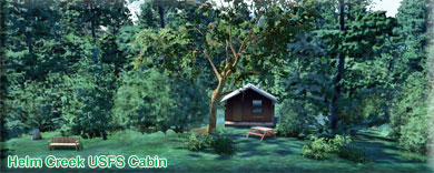
VFR Comments: The Helm Creek Cabin is only a couple of miles from the Helm Bay Cabin. You will fly directly over a small island to the starboard shoreline on a heading of 330°. The cabin is at the end of the peninsula created by Helm Creek, but on the far side from your approach. USFS Cabin Information: This is a rustic style 12' x 14' log cabin that was built in 1985. This cabin faces to the northwest with a good view toward the head of Helm Bay. It is adjacent to a large saltwater tidal flat at the outlet of Helm Creek. The Helm Bay area is noted for crab, salmon, halibut, and red snapper. FACILITIES: • Two Single & Two Double Bunks • Wood Stove and Firewood • Cooking Counter and Table • Shelves and Cupboard Space • Ax/Maul/Splitting Wedges • Broom. Leg 4 - McDonald Lake Cabin (and observatory)
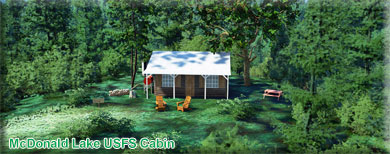
VFR Comments: The safest route to McDonald Lake Cabin with in-climate weather is to fly back to the Behm Canal (about 3 miles) on a heading of 105°. When you reach Helm Point (last point on starboard shore, you turn to port and follow the coastline to Spacious Bay on a 345° heading for 16 miles. When you see the beginnings of Spacious Bay, you turn to a direct heading to the cabin on 325°. As you approach the terrain past spacious bay, 1600 feet is the safe altitude until you get to McDonald Lake. After the terrain you will pass over Yes Bay. You will fly over the Bear Observatory and the Cabin. The "Drop off" point is down on the water in front of the cabin. You will find a small shelter there for dropping off and picking up passengers and supplies. USFS Cabin Information: This is a rustic style 12' x 14' Pan-Abode log cabin that was constructed in 1967. There is trail access to Wolverine Creek and a 1930's Civilian Conservation Corp (CCC) 3-sided shelter. There are steel-head and salmon runs up Wolverine Creek with resident trout and dolly Varden throughout the lake. FACILITIES: • Two Single & Two Double Bunks • Wood Stove and Firewood • Cooking Counter and Table • Shelves and Cupboard Space • Ax/Maul/Splitting Wedges • Broom. Leg 5 - Blind Pass Cabin
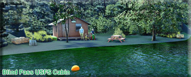
VFR Comments: 1200' is the safe altitude for this leg. From McDonald Lake Drop Off area, fly 150° back to Yes Bay (about 2 miles). Follow Yes Bay to the Behm Canal on a rough heading of 105°. Leaving Yes Bay, fly on a heading of 060° to Blind Pass, only 3 miles. Fly 2/3 of the pass, the cabin is in a cove on the starboard shore. USFS Cabin Information: This is a rustic style 12' x 14' Pan-Abode log cabin with sleeping space for 4 to 6 people. The cabin was constructed in 1975. Nestled in a sheltered cove, it is a great jumping-off spot for exploration of various bays and inlets in the northern Behm Canal area. The area is noted for salmon, halibut, red snapper, and shrimp. A fresh water lake with trout is located about 1/2 mile upstream from the cabin. There is no trail to the lake. Mooring buoy is available on a first-come, first-serve basis. FACILITIES: • Two Single & Two Double Bunks • Oil Stove (#1 Diesel fuel NOT provided) • Cooking Counter and Table • Shelves and Cupboard Space • Broom Leg 6 - Reflection Lake USFS Cabin
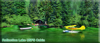
USFS Cabin Information: Reflection Lake Cabin is situated on the Cleveland Peninsula at the shore of Reflection Lake approximately 50 air miles from Ketchikan. The cabin is available year-round and makes an excellent base for experiencing this corner of Alaska with its recreation options, beautiful scenery and abundant wildlife. The cabin is remote and accessible only by float plane or boat, depending on conditions. Boats can be moored in Short Bay, and visitors can hike 2.3 miles to the cabin along the Reflection Lake Trail. This primitive cabin has no electricity, indoor plumbing or cell phone coverage. Visitors are responsible for their own travel arrangements and safety, and must bring several of their own amenities. Leg 7 - Anchor Pass USFS Cabin
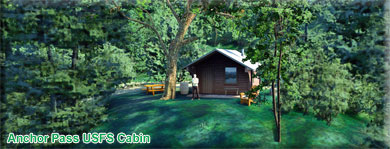
VFR Comments: Leave Reflection on a reverse course back to the Behm Arm. (Head about 150° and follow the low terrain, turning to the left, then to the right over Short Bay. Follow Short Bay to the Behm Arm. Near the end of Behm Arm, turn right into Anchor Pass and follow it to nearly the end. The cabin drop-off point is on the port shoreline. This cabin is a mile hike up the mountain, so we pick up and drop passengers and supplies at the drop-off point, a small shelter at the trail head. (see pic above for drop-off). USFS Cabin Information: This is a rustic style 12' X 14' Pan Abode cabin constructed in 1975. The cabin contains a oil burning stove, and sleeping space for 4 to 6 people. The front deck offers a spectacular view of the mountains on Revillagigedo Island. The area is noted for abundant saltwater fishing including halibut, salmon, and shrimp (Please note sport-fishing restrictions on salmon fishing in areas close to the cabin). A mooring buoy is available on a first-come, first-serve basis. FACILITIES: • Two Single & Two Double Bunks • Wood Stove and Firewood • Cooking Counter and Table • Shelves and Cupboard Space • Ax/Maul/Splitting Wedges • Broom Leg 8 - Plenty Cutthroat USFS Cabin
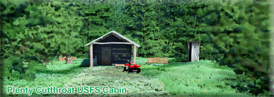
VFR Comments: Leave Anchor Pass on a heading of 150°. When you reach the Behm Narrows (at end of Anchor Pass), turn right int Behm Narrows. In about 5 miles, follow the port shoreline for a 090. The Behm Narrows turns slightly to port, you turn 090° left into Bassler Pass. (Stay to the port shoreline). As you come to the end of Bassler Pass, stay to the port shoreline and turn left into Gadney Pass. As you near the end of Gadney Pass, go into Shrimp Bay, to the right ending of Gadney Pass. At the end of Shrimp bay is a low ridge. On the other side of that ridge is Orchard Lake, the cabin drop-off site is on the far side of that ridge as the lake begins on the port shore. Be in landing approach mode when going over the ridge. The cabin is on the back side of a little peninsula on the port shore. There is a path from the drop-off location up to the cabin, about a 1 mile hike. USFS Cabin Information: This is a rustic style 12' x 12' Pan-Abode log cabin that was constructed in 1964. A trail from the cabin climbs through old-growth rainforest then down to saltwater. There is a trail junction that leads to the lake outlet and a trail spur that leads to an overlook that views one of the two waterfalls spilling out of Orchard Lake. FACILITIES: • Two Single & Two Double Bunks • Oil Stove (#1 Diesel fuel NOT provided) • Cooking Counter and Table • Shelves and Cupboard Space • Broom • 14’ aluminum skiff with oars. Leg 9 - Patching Lake USFS Cabin
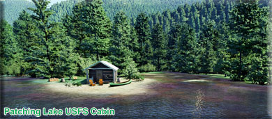
VFR Comments: Fly the length of Orchard Lake on a heading of about 090°. When you get to the end of the lake, follow the low terrain until you see a break in the mountains to starboard. Turn into that break still following the low terrain. There will be a "Y" intersection ahead for the low terrain, keep to the port (left) and continue toward the water ahead (Carroll Inlet). Fly for about 5 miles down the Carroll until the mountains on the left get smaller, then turn to the right, keeping the mountains to your right. As you circle them, you will come upon the Heckman Lake area. When Heckman is ahead, look for Patching on the right. the cabin is at the far end of the lake, starboard side where the creek comes into the lake. USFS Cabin Information: This is a rustic style 12' x 14' Pan-Abode log cabin that was constructed in 1975. The cabin is located on a beautiful site where the Naha River flows from Chamberlain Lake into Patching Lake. This is an area of old-growth cedar, Sitka spruce, and western hemlock rainforest. There are resident cutthroat trout in Patching and Chamberlain Lakes. There is no trail to Chamberlain Lake. FACILITIES: • Two Single & Two Double Bunks • Wood Stove and Firewood • Cooking Counter and Table • Shelves and Cupboard Space • Ax/Maul/Splitting Wedges • Broom • 14’ aluminum skiff with oars. Leg 10 - Jordan Lake USFS Cabin
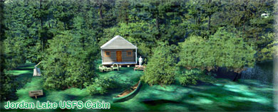
VFR Comments: Leaving Patching Lake, fly on a heading of 161° back down the lake. When you get to the end of the lake, turn to the right and you will see Heckman Lake. As you come over the near shore, you are overflying the Heckman Fish Hatchery, some white buildings on the near shore. Continue to fly down the lake. Look to the port shoreline and you might see the SE Heckman Lake Cabin, then around the last point of the lake to the left is the Heckman Lake Cabin. We will be coming back to these. Fly straight ahead off the lake and in a mile you will see Jordan Lake. Be in landing configuration ready for an STOL type landing, it is a short landing zone. Once you land, circle to the left around the lake. You will see where the Naha River begins. Continue around the lake and you will find the Jordan Lake Cabin on a peninsula. USFS Cabin Information: This is a rustic style 12' x 12' Pan-Abode log cabin that was constructed in 1965. The cabin is accessed by the Naha Trail which winds along the Naha River through old-growth rainforest of spruce and hemlock. FACILITIES: • Two Single & Two Double Bunks • Wood Stove and Firewood • Cooking Counter and Table • Shelves and Cupboard Space • Ax/Maul/Splitting Wedges • Broom •14' aluminum skiff with oars. Leg 11A - Heckman Lake USFS Cabin
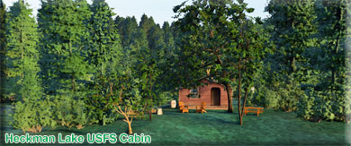
VFR Comments: You will be taking off on a heading of 129°. Give yourself enough room for take-off! Head toward the light green area and fly over it, being ready to land in about a mile at the leading edge of Heckman lake. The Heckman Lake Cabin is on the first peninsula on the starboard shore. USFS Cabin Information: This is a rustic style 12' x 14' Pan-Abode log cabin that was constructed in 1967. It is located near the outlet of Heckman Lake at the terminus of the six-mile Naha National Recreational Trail that winds along the Naha River through old-growth rainforest of spruce and hemlock. FACILITIES: • Two Single & Two Double Bunks • Wood Stove and Firewood • Cooking Counter and Table • Shelves and Cupboard Space • Ax/Maul/Splitting Wedges • Broom •14' aluminum skiff with oars. Leg 11B - S.E. Heckman Lake USFS Cabin
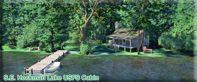
VFR Comments: Taxi around the peninsula coming to about 120° and take a short hop down to the next peninsula on the starboard shore. The SE Heckman Lake Cabin is just beyond that peninsula. USFS Cabin Information: This is a 2-room 16’x22’ Pan-Abode log cabin that was constructed in 1997. This is a barrier free facility from the dock to the cabin. The cabin is one of two Forest Service cabins on Heckman Lake and offers great scenery and solitude. This cabin is not accessible by the Naha River trail, though the trail can be paddled to with the skiff that is present at the cabin. FACILITIES: • Two Single, Two Double Bunks, & One single bunk • Wood stove, ax, maul, wedge, wood • Cooking Counter and Table • Shelves and Cupboard Space • Broom • 14' aluminum skiff with oars, and dock. Leg 11C - Heckman Lake Fish Hatchery
VFR Comments: You can taxi over to the next location, the fish hatchery. Set a course at about 100° and head for the far end of the lake. On the port shore, you will find the Heckman Fish Hatchery. Location Information: We don't have any information on the hatchery (would like some if you can find it). It is showing on the sectional so we thought we would add it for you. Leg 12 - Manzanita Lake Cabin
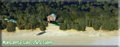
VFR Comments: Taxi back out onto the lake giving yourself sufficient room to take off on a heading of 345°. You do not fly up the narrow leg of the lake, you fly a few degrees to the left of it keeping the small mountain off your port wing and flying the low terrain. You will fly over a small lake, then see a larger, narrow lake ahead. that is Manzanita Lake. Fly almost to the end of it, then turn sharply to port to follow the westward turn in the lake to the end. The cabin is on the port shore near the last turn in the lake. (There is usually ice at this lake just beyond the cabin. USFS Cabin Information: Manzanita Lake Cabin is located on the scenic northwest arm of Manzanita Lake approximately 28 miles northeast of Ketchikan on Revillagigedo Island. The cabin offers recreational and wildlife viewing opportunities and makes an excellent base for experiencing this corner of Alaska. Constructed in 1973, the 12x14-ft. pan-abode style cabin can accommodate 6 people with 2 single bunks and 2 double bunks. Other amenities include a table with benches, a cooking counter, food storage, broom and an oil stove for heat. An outhouse is located nearby. The cabin is located about 100 yards from the lake shore beside a spectacular series of cascading waterfalls. Visitors can also enjoy views of steep granite walls and snow-capped peaks. The cabin is surrounded by large old-growth spruce, hemlock and cedar. The Misty Fjords Monument Wilderness supports a diverse variety of wildlife. Mountain goats, bears, deer, moose and bald eagles make their home here (bear safety). Many species of birds may be seen in or around the lake, and visitors may catch a glimpse of beavers in the area. Leg 13 - New Eddystone Rock
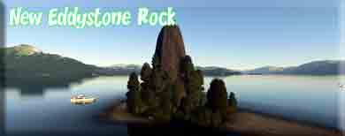
VFR Comments: Leave Manzanita Lake on a heading of about 80° for 2 miles and encounter the Behm Canal. Turn to about 126° at the Behm shoreline and you will see New Eddystone Rock dead ahead in the center of the canal. POI Information: During the last ice age, Southeast Alaska was covered by a thick ice sheet. The weight of the ice pressed down and compressed the underlying crust, including the area that is now Behm Canal. As the ice melted at the beginning of the current interglacial period, this weight was reduced. The Earth's crust responded by flexing upward, a process known as isostatic rebound. This movement broke the rock and created a New Eddystone volcano that erupted 15,000 to 13,800 years ago. The volcano rises from the bottom of Behm Canal, about 850 feet (260 m) below sea level.[3] The island stands to 237 feet (72 m) above sea level, giving the volcano a total height of over 1,000 feet (300 m). While the portion of the volcano below sea level is somewhat cone-shaped, wave action over the millennia has eroded all the rock above sea level except the dense, spire-shaped volcanic plug. Bathymetric studies of the floor of Behm Canal show that New Eddystone was not the only volcano that emerged as the crust buckled. Four other vents have been identified. Two are dome-shaped, suggesting that they erupted below the glacial ice sheet and were rounded off as the ice flowed over them. The other two, and New Eddystone Rock, are more pointed showing that they had never been overridden by ice. Of the five identified volcanic vents in Behm Canal, only New Eddystone Rock rises above sea level. Leg 14 - Punchbowl Lake Shelter VFR Comments: Leave New Eddystone Rock on a heading of about 034° to the outfall of the Rudyerd Inlet. Go into the inlet on a heading of about 089° and Punchbowl lake is ahead over the hill crest in about 2 miles. The Shelter is on the near shoreline. USFS Cabin Information: This three-sided shelter is located at the end of the Punchbowl Lake trail. This area supports a variety of birds and wildlife, and offers some of the most spectacular scenery in Misty Fiords. Steep granite cliffs, glacially-carved valleys and dense rainforests make this a beautiful and popular destination. Punchbowl Cove is located near the mouth of Rudyerd Bay, which branches east off the Behm Canal in Misty Fiords National Monument. Access is by boat or floatplane. There is also a mooring buoy located in Punchbowl Cove. Leg 15 - Big Goat Lake Cabin
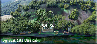
VFR Comments: Take off on a heading of 086° and wind a little to port around the mountains to Big Goat Lake that is a bout 3 miles ahead. USFS Cabin Information: The Big Goat Cabin was a Forest Service public rental building originally constructed in 1964.The cabin is a Pan Abode style building made of dimensional lumber, precut interlocking cedar logs and corrugated aluminum roofing. The door is off center to the right. There is no window on the front elevation. A rectangular porch extends across the width of the building and is flush with the ground. A plank boardwalk trail leads off the front porch down to the lake. A second boardwalk trail leads behind the cabin and to the left, up a series of steps, to what used to be an outhouse that was built in 1983. The outhouse is now gone. A fire ring is in front of the cabin and a boat ramp is at the lake edge. The cabin is in an alpine lake setting, at 1,775 ft. in elevation. Its location is one of the most popular in Misty Fiords for authorized floatplane landing tours, where guided clients are often brought to the shoreline during the summer months. Leg 16 - Wilson View Cabin
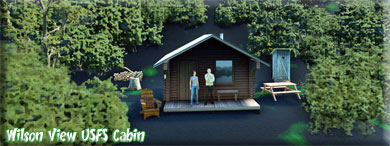
VFR Comments: From Big Goat Lake, take off on a heading of 085°. As you come off the end of the lake, your target cabin is sharply DOWN and to the left. It is safer to turn right at the end of the lake following Wilson Lake and decreasing altitude. When safe, turn 180 to port and fly back up to the end of the lake and land. There is a little shelter at the drop off site. You will see a trail that leads to the cabin, high above you on the cliff. USFS Cabin Information: This is a rustic style 12' X 14' Pan Abode log cabin that was constructed in 1977. This cabin lies on the north end of this long and narrow glacially carved lake. While you explore the lake you can enjoy the rugged terrain looming overhead. Wildlife viewing and fishing are popular activities in this area, so bring your fishing pole and camera and enjoy a relaxing day on the lake. FACILITIES: • Two Single & Two Double Bunks • Fuel Oil Stove (#1 Diesel fuel NOT provided) • Cooking Counter and Table • Shelves and Cupboard Space • Broom •????14' aluminum skiff with oars Leg 17 - Wilson Narrows Cabin
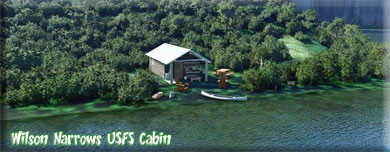
VFR Comments: Leaving Wilson View Drop off, fly low and slow on a heading of about 200° flying down the lake. You will find the cabin toward the end of the lake on the port shore. USFS Cabin Information: Wilson Narrows Cabin is situated on the south end of Wilson Lake approximately 44 air miles northeast of Ketchikan. The cabin is available year-round and makes an excellent base for experiencing this corner of Alaska with its recreation options, beautiful scenery and abundant wildlife. The cabin is remote and does not have electricity, indoor plumbing or cell phone service. It is accessible only by float plane, depending on conditions. Visitors are responsible for their own travel arrangements and safety, and must bring several of their own amenities. Leg 18 - Checats Lake Cabin
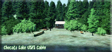
VFR Comments: From Wilson Narrows, wind your way through the mountains on a rough heading of 252° for 8.2 miles to find Checat's Lake. The cabin is on the far shore of the lake. USFS Cabin Information: This is a rustic style 12' X 12' Pan Abode cabin with sleeping space for 4 to 6 people. The cabin sits on a little knoll at the outlet of the lake, so stream and lake fishing is abundant. The land formations and the location of the cabin provides many scenic and wildlife photo opportunities. FACILITIES: • Two Single & Two Double Bunks • Wood Stove and Firewood • Cooking Counter and Table • Shelves and Cupboard Space • Ax/Maul/Splitting Wedges • Broom •14' aluminum skiff with oars. Leg 19 - Winstanley Lake Cabin
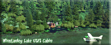
VFR Comments: From Checats Lake, taxi east back up the lake to on a heading of 159°. Follow the lake to its end, climbing to 3300 feet and turn to 187° for Winstanley Lake 3.2 miles ahead. As you cross the 3300 foot ridge, the lake is just on the other side. You will probably have to circle to land. You will be flying over the cabin on the near shoreline. USFS Cabin Information: This is a rustic style 12' X 14' Pan Abode log cabin that was constructed in 1967. There are many recreation opportunities in this area. Boating down to the end of the lake will take you to the historic Winstanley Lake Shelter constructed by the CCC back in the early 1930’s. From the shelter there is a 2.25 mile hike down to salt water. FACILITIES: • Two Single & Two Double Bunks • Wood Stove, Axe, Maul, Wedge, Wood • Cooking Counter and Table • Shelves and Cupboard Space • Broom •14' aluminum skiff with oars. Leg 20 - Winstanley Island Cabin
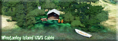
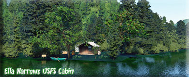
VFR Comments: Leaving Winstanley Lake, fly a heading of 277° for 3.3 miles to Winstanley Island. USFS Cabin Information: This is a rustic style 12' X 14' cabin that was constructed in 2010. There are a number of scenic attractions within easy boating distance; Rudyerd Bay, Walker Cove, Chickamin River, Smeaton bay, and the entire east Behm Canal. There are several trails to fresh water streams and lakes, and hunting areas. Leg 21 - Ella Narrows Cabin
VFR Comments: From Winstanley Island, fly a heading of 271° for 6.6 miles. You will be again crossing the Behm Canal, and you will see New Eddystone Rock again off the starboard wing. USFS Cabin Information: This is a rustic style 12' X 14' Pan Abode cabin that was constructed in 1966. This cabin provides a great opportunity for fishing, hiking, and exploring around Ella Lake. FACILITIES: • Two Single & Two Double Bunks • Wood Stove and Firewood • Cooking Counter and Table • Shelves and Cupboard Space • Ax/Maul/Splitting Wedges • Broom •14' aluminum skiff with oars. Leg 22 - Fish Creek Cabin
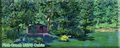
VFR Comments: Leave Ella Narrows on a heading of 195 and maintain that heading to Fish Creek Cabin. It is possible to stay at lower altitudes if you plan your vfr journey carefully. The cabin is at the far end of the lake where Fish Creek leaves the lake for the George Inlet. USFS Cabin Information: This is a rustic style 12' x 14' Pan-Abode log cabin that was constructed in 1978. The cabin is located where Fish Creek cascades into Thorne Arm. The creek supports salmon runs as well as resident trout and dolly Varden. Two trails are accessible from the cabin site: Low Lake Trail and Gokachin Lake Trail. Please note that neither trail receives regular maintenance. FACILITIES: • Two Single & Two Double Bunks • Oil Stove (#1 Diesel fuel NOT provided) • Cooking Counter and Table • Shelves and Cupboard Space • Broom Leg 23 - Bakewell Lake Cabin
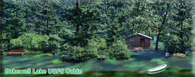
VFR Comments: Fly off the lake at 333° and once at sufficient altitude, come to a heading of 92° for 19 miles to find Bakewell Lake. As you approach the lake area you can go lower over the waterways to reach the lake. The cabin is on the port shoreline about 1/4 of the length of the lake. USFS Cabin Information: This is a rustic style 12' X 14' Pan Abode cabin constructed in 1978. The cabin contains an oil burning stove (use # 1 diesel fuel) and sleeping space for 4 to 6 people. This cabin is ideal for families with kids or anyone who enjoys lazy days on the beach. It has a nice white sand beach and lots of room to spread out. There is a trail from saltwater to the lake, but it does NOT lead all the way to the cabin. There is NO mooring buoy at the trail head. FACILITIES: • Two Single & Two Double Bunks • Fuel Oil Stove (#1 Diesel fuel NOT provided) • Cooking Counter and Table • Shelves and Cupboard Space • Broom •14' aluminum skiff with oars Leg 24 - Hugh Smith Lake Cabin
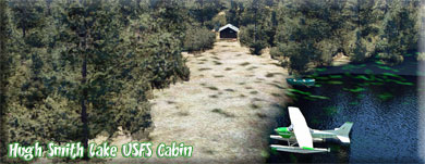
VFR Comments: Take off Bakewell Lake on a heading of about 196. At the end of the lake, come to a heading of 146° and follow the valley there for about 9 miles to find Hugh Smith Lake. As you near the lake, there is a large waterway, then a mountain ridge. If you go to starboard and go around the mountain, there is a way into the lake that makes landing much easier. USFS Cabin Information: Hugh Smith Lake Cabin is located on the mainland within the Misty Fjords National Monument Wilderness. This rustic, secluded retreat is open year-round for relaxation and recreation in Alaska's beautiful Inside Passage. The site can be accessed by float plane, depending on conditions. Guests are responsible for their own travel arrangements and safety, and must bring several of their own amenities. Leg 25 - Humpback Lake Cabin
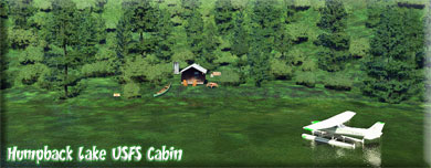
VFR Comments: Leaving Hugh Smith Lake Cabin, set a heading of about 250° to fly to the end of the lake. At the end, turn to port into Mink Bay. As you read the end of Mink Bay you will see an outlet of water to port, turn over that water. You will see a large hill ahead, fly around the hill to the left and you will see water ahead. That is Humpback lake. The Humpback Lake Cabin is about 1/2 the way down the lake on the port shoreline. USFS Cabin Information: This is a rustic style 12' X 14' Pan Abode cabin that was constructed in 1979. This cabin features spectacular views of high alpine peaks with sheer granite walls. A commercial lodge is located at the southeast end of the lake. From the cabin, you can row to the Humpback Lake trail head and enjoy a hike to saltwater. FACILITIES: • Two Single & Two Double Bunks • Oil Stove (#1 Diesel fuel NOT provided) • Cooking Counter and Table • Shelves and Cupboard Space • Broom •????14' aluminum skiff with oars Leg 26 - Alava Bay Cabin
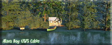
VFR Comments: Leave Humpback Lake on a rough heading of 279° that you will follow for almost 24 miles. You are heading back toward the Behm Canal. You will cross the Behm and see a bay ahead, that is Alava Bay. the cabin is near the center of that bay. USFS Cabin Information: This is a rustic style 12' X 14' Pan Abode cabin with a wood burning stove, and sleeping space for 4 to 6 people. The cabin offers deck space and warm sunshine early in the morning (on clear days). Saltwater fishing and sightseeing are the main attractions in this area. Other opportunities exist for hiking, hunting, and beach combing. A mooring buoy is available on a first come, first serve basis. FACILITIES: • Two Single & Two Double Bunks • Wood Stove • Cooking Counter and Table • Shelves and Cupboard Space • Broom.Leg 27 - Phocena Bay Cabin
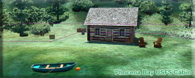
VFR Comments: Leaving Alava Bay, it is easies to go on a heading of 170° leaving the Behm Canal and heading into the big channel. At this point you set a heading of 247° for 24 miles. You will be crossing over Annette Island. On the other side of the island, Dall Head should be dead ahead. Lose altitude toward 1200 feet and go left, around the head. Phocena Bay is the first bay on the starboard shore. The cabin is in the bay. USFS Cabin Information: This is a rustic style 12' x 14' Pan-Abode log cabin that was originally constructed in 1973 and moved to it's current location in 1985. There is a spectacular view of Chapin Peak and the Puppet Mountains from the cabin deck and relatively easy hiking in the area to explore nearby tide pools and forest. There is also the opportunity to see humpback and killer whales in Clarence Strait. FACILITIES: • Two Single & Two Double Bunks • Wood Stove and Firewood • Cooking Counter and Table • Shelves and Cupboard Space • Ax/Maul/Splitting Wedges • Broom. Leg 28 - Ketchikan Int'l VFR Comments: We now return to Ketchikan, PAKT. You leave Phocena Bay flying 150° keeping the shore to your left. You fly around Dall Head over the little Bronaugh Islands. Continue a slow turn to port until you are at 354°. This is the course to the Tongass Narrows. You will pass by Bostwick Bay (This is where Misty's Place" is located). When you reach the Tongass Narrows, turn left and line up for Ketchikan, PAKT. We hope you enjoyed the Dispatch.
|
| Report any problems with this dispatch to Web master at RTMM. |
| Return to Misty Moorings Copyright 2021 |