
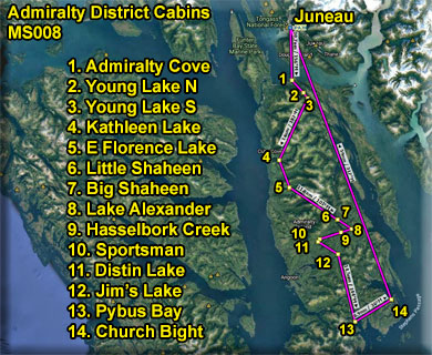
| VFR - USFS Admiralty District Cabins |
Click for Enlarged Map
 |
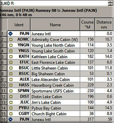
| Written Flight Plan |
| Download Flight Plan |
|
Juneau (PAJN Start)
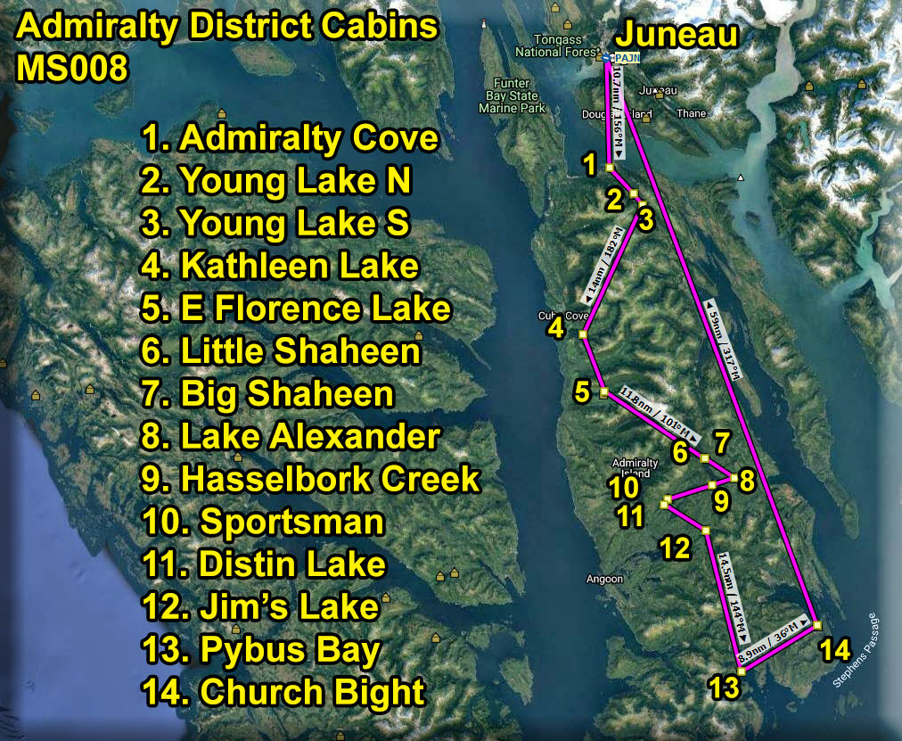
Our dispatch starts at Juneau Airport, (PAJN). The highest terrain during this trip is about 3300 feet, so all WayPoints will show 3600 feet. All locations are, in fact, nearly at sea level. You can fly directly to each location if the weather is good and you have sufficient equipment. The "VFR Comments" in the legs below are designed for (more typical) poor weather conditions ... keeping you at about 1200 feet and over water. Remember, in the real world, people have rented these cabins months in advance, they've flown to Alaska and now expect to go to the cabin they are paying for. So the pilots have to fly in less-than-perfect weather conditions often to meet this "hotel schedule-like" demand. You can read about the actual cabin facility in the USFS Cabin Information section for each location. Leg 1 - Admiralty Cove USFS Cabin
VFR Comments: A safe altitude for this leg is 1200 feet if you stay over the water. We take off from Juneau PAJN and follow a heading of 213° to the shoreline of Douglas Island. We will keep that shoreline to port as we follow it around until you are on a heading of 136° ... at this point, fly straight ahead on the 136° heading. You will be crossing Stephens Passage on the way to Admiralty Cove.
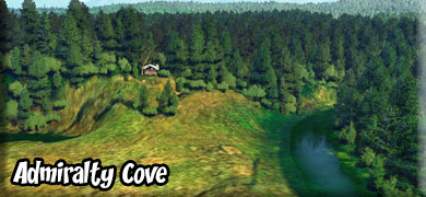
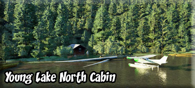
There are two ways to land at this cabin: 1. Land - At the far end of the cove is a tidal meadow. Fly to the right of the meadow and you will see a river circling it around from left to right. Be in landing position. Follow low over the river and head toward the bench ahead. There is a short landing zone before the bench, but it is has a river at its beginning and end. 2. Water - fly to Admiralty Cove to the port shoreline, you will see a small shelter on the shoreline. This is one of the drop-off places for this cabin. The cabin itself is about 3 miles inland on a bench overlooking the beautiful tidal meadow. When you depart you should take a pass over the meadow and see the cabin. Cabin Information: This is a typical Pan Abode cabin with an oil stove for heat. It has sleeping space for 4 to 6 people. An old CCC shelter is on site providing an additional covered area. The cabin rests on a level bench overlooking Admiralty Creek and a large grassy tidal meadow. Facilities: 2 single wooden bunks, 2 double wooden bunks, Cooking counter, Broom, Oil stove (uses #1 stove oil, NOT provided),Table and benches. The water source is poor. Admiralty Creek has a tide water influx at high tides. Treat all water before using. Bring your own #1 stove oil, sleeping bags, sleeping pads, cooking stove, lantern, pots, pans, plates, utensils, food, toilet paper, garbage bags, fire extinguisher, and fire starter. Please follow the oil stove directions carefully. You are in brown bear country. Bears frequent the area and trail particularly during salmon runs July through August. In addition to fishing, popular activities include wildlife viewing (brown bear, deer, and waterfowl can often be seen in the nearby area), berry picking and beach combing. The Admiralty Cove-Young Lake trail is a 4½ mile trail that departs from the cabin and ends at the North Young Lake cabin. It is a relatively flat trail and follows the creek at each end of the trail. The round trip hike can be fairly strenuous when conditions are very wet. Leg 2 - Young Lake North USFS Cabin
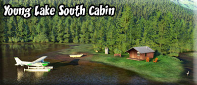
VFR Comments: From the tidal meadow area, fly on a heading of 114° for 3.5 miles to Young Lake. You will be following a valley. Land at the beginning of the lake and Young Lake North USFS Cabin will be on the beginning of the port shoreline. Cabin Information: This Pan Abode cabin with a sleeping space for 4 to 6 people sits back 50' (15 m) from the lake edge under a canopy of trees and small beach. Facilities: 2 single wooden bunks, 2 double wooden bunks, cooking counter, broom, outhouse, oil stove (uses #1 stove oil, NOT provided), skiff with oars, table and benches. Water is available from the lake. Treat all water before using. Bring your own personal flotation devices, sleeping bags, sleeping pads, cooking stove, lantern, pots, pans, plates, utensils, food, toilet paper, garbage bags, fire extinguisher, and fire starter. Please follow the oil stove directions carefully. Cabin users may also choose to bring a small outboard motor (less than 10 horsepower due to wilderness regulations). This is 1 of 2 cabins on the lake (the other is the South Young Lake cabin). You are in brown bear country. Bears frequent the area and trail particularly during salmon runs July through August. The Admiralty Cove-Young Lake trail is a 4½ mile trail that departs from the cabin and ends at the Admiralty Cove cabin. It is a relatively flat trail and follows the creek at each end of the trail. The round trip hike can be fairly strenuous when conditions are very wet. The lake is on a flight path and has substantial overhead plane traffic. Leg 3 - Young Lake South USFS Cabin
VFR Comments: Young Lake South Cabin is only 1.5 miles away. You may want to taxi to this or just do a very short "hop". Go on a heading of about 120° to the end of the lake and watch for the cabin located at the creek exiting the lake on the far shoreline at the end of the lake. Cabin Information: his Pan Abode cabin sits back 30' (9 m) from the lake in a large open area on flat ground and sleeps 4 to 6 people. The cabin and flat beach are in full sun exposure. Facilities:2 single wooden bunks, 2 double wooden bunks, Broom, Outhouse, Oil stove (uses #1 stove oil, NOT provided), Skiff with oars, Table and benches, Cooking counter. Water is available from the lake. Treat all water before using. Bring your own personal flotation devices, sleeping bags, sleeping pads, cooking stove, lantern, pots, pans, plates, utensils, food, toilet paper, garbage bags, fire extinguisher, and fire starter. Please follow the oil stove directions carefully. Cabin users may also choose to bring a small outboard motor (less than 10 horsepower due to wilderness regulations). This is 1 of 2 cabins on the lake (the other is the North Young Lake cabin). You are in brown bear country. Both brown bear and deer can be seen in the area. The lake is on a flight path and has substantial overhead plane traffic. Leg 4 - Kathleen Lake USFS Cabin
VFR Comments: Your "direct" path to Lake Kathleen takes you over some higher mountains, about 3800 feet, you can fly direct, but if you want to stay "low and slow", here is what you do. You fly back over Young Lake and fly over the tidal meadow at Admiralty cove, then follow the shoreline to port. You will fly about 16 miles to the lake's vicinity. As you leave the meadow, Young Bay will be to starboard. Apparently named by W. H. Dall, U.S. Coast and Geodetic Survey (USC&GS) and published in 1883 Coast Pilot (p. 172). The name probably derived from Point Young which was named by Captain George Vancouver, Royal Navy (RN) in 1794. As you reach the end of Young Bay, fly straight over the land to the next body of water you will see, Hawk Inlet. Turn to port and follow Hawk Inlet. About half way down Hawk Inlet, you will see the Hawk Inlet SPB and cannery. You will fly over Point Marsden at the end of the inlet and continue on a 165° heading down the shoreline of Admiralty Island. Kathleen Lake is ahead about 11 miles. Fly over the low hills onshore (beside the mountains) and keep watching to your left for Kathleen lake. The lake is in the shape of a "C" and goes off directly to port from you. You will see some excessive forest fire damage in this area. Follow the lake to the end and land. There is a small shelter at the shoreline for the passenger and supply drop-off, but you can see the path to the cabin about 100 years inland. (This is an RTMM-Created Lake) Cabin Information: This is a small dark A-frame cabin, within Native selected lands, with sleeping space for 4 to 5 people. The cabin sits on level ground 200' (61 m) from the beach within a small parcel of timber. Much of the surrounding area is private land and has been has been clearcut. The area around the cabin shows a patchwork pattern of logged and unlogged areas. Facilities: 2 single wooden bunks, Sleeping loft, Broom, Cooking counter and shelves, Oil stove (takes #1 fuel oil, NOT provided),Outhouse, Table and benches, Skiff with oars. Water is available from the lake. Treat all water before using. The cabin has an oil stove for heat. Bring your own #1 fuel oil, personal flotation devices, sleeping bags, sleeping pads, cooking stove, lantern, pots, pans, plates, utensils, food, toilet paper, garbage bags, fire extinguisher, and fire starter. Please follow the oil stove directions carefully. Cabin users may also choose to bring a small outboard motor (less than 10 horsepower due to wilderness regulations). You are in brown bear country. The area surrounding the cabin has been clearcut fairly recently. An active road system encompasses the lake. You are surrounded by Shee Atika Corporation lands and a permit is necessary to hike from the cabin. Leg 5 - East Florence USFS Cabin
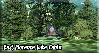
VFR Comments: Fly back over Kathleen Lake on a 280° heading and go to the coastline and follow it to port on a heading of about 160°. You will fly about 5 miles along this shoreline. Watch for a long and narrow lake to port. That is East Florence Lake. (This is an RTMM-Created lake). Cabin Information: This is a large A-frame cabin, with sleeping space up to 7 people. The cabin sits back 150' (46 m) from a nice beach. Much of the surrounding area is private land and has been clearcut. Clearcuts and roads are visible from the cabin. Facilities: 3 single wooden bunks, Sleeping loft, Oil stove (uses #1 fuel oil, NOT provided),Table and benches, Cooking counter, Broom, Outhouse, Skiff with oars. Water is available from the lake. Treat all water before using. Also bring your own personal flotation devices, sleeping bags, sleeping pads, cooking stove, lantern, pots, pans, plates, utensils, food, toilet paper, garbage bags, fire extinguisher, and fire starter. Please follow the oil stove directions carefully. You are in brown bear country. Both brown bear and deer can be seen in the area. Deer hunting is a popular fall activity. A 1-mile (1.6 km) trail to saltwater begins on the north side of the outlet stream at the west end of the lake. You are surrounded by Shee Atika Corporation lands and a permit is necessary to hike from the cabin. Leg 6 - Little Shaheen USFS Cabin
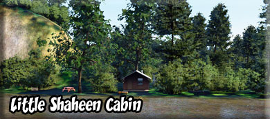
VFR Comments: Once again, fly back over the lake to the shoreline and turn to port. Your heading over the lake will be about 235°. About 1 mile down the shoreline and you will come to a wide valley bearing off to port. Follow that valley on a course of about 130°. The valley splits, take the right fork staying on 130°. After a few miles you will see a lake ahead and veering off to port. This is Thayer Lake. Turn to 025° and fly over the lake. At the end of Thayer lake, continue up the valley ahead. Toward the end of the valley, bear right over a small lake, then out over Hasselborg Lake. Turn right over Hasselborg Lake and go into landing configuration. Little Shaheen Cabin is on the port shore at the point 2 miles ahead. Cabin Information: Little Shaheen Cabin offers guests recreation, relaxation and a unique wilderness lodging experience in the central part of Admiralty Island in the Tongass National Forest. The remote site offers a scenic setting for hiking, fishing, canoeing and wildlife viewing, all within the vicinity of the cabin. Leg 7 - Big Shaheen USFS Cabin
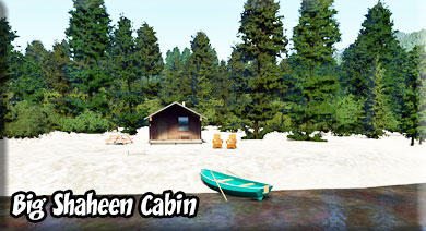
VFR Comments: The Big Shaheen Cabin is less than a mile away. Taxi on a heading of 170° and go around the point. You will find the Big Shaheen Cabin on a wide beach in about 200 yards. Cabin Information: This is a rectangular log cabin built in 1936 by the CCC. Two sleeping rooms are divided from the oil stove and cooking area. The cabin has sleeping space for 4 to 8 people. The cabin sits on level ground with a large beach. Facilities include 2 double wooden bunks, 2single upper bunks, maul, oil stove(uses #1 stove oil, NOT provided), axe, table and bench, wood, cooking counter, broom, skiff with oars. Water is available from the lake. Treat all water before using. Bring your own personal flotation devices, sleeping bags, sleeping pads, cooking stove, lantern, pots, pans, plates, utensils, food, toilet paper, garbage bags, fire extinguisher, and fire starter. Please follow the oil stove directions carefully. Cabin users may also choose to bring a small outboard motor (less than 10 horsepower due to wilderness regulations). You are in brown bear country. This is 1 of 3 cabins on Hasselborg Lake (the other two are Hasselborg Creek and Little Shaheen). The lake is very popular and has a lot of float plane traffic. Little Shaheen cabin is close by, connected by a 100 yard (91 m) trail. Four trails are accessible by boat. The lake is 7 miles (11 km) long and part of the Cross Admiralty Canoe route. Leg 8 - Alexander Lake USFS Cabin
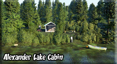
VFR Comments: Take off from Big Shaheen on a heading of 101° and maintain that heading for 3.5 miles. You will first fly over Beaver lake. Only a finger of land separates the two lakes. Be in landing configuration, Alexander Lake is the next lake and the cabin is on the shore you will be flying over, so land just beyond the shore, turn around and taxi back to the Lake Alexander Cabin. (Both Beaver and Alexander Lakes were created by RTMM) Cabin Information: This is a typical Pan Abode cabin with a wood stove and sleeping space for 4 to 6 people. The cabin sits 30' (9 m) above the lake. There is a beach with some exposure to the sun. It has a nice overlook of the lake. Facilities: 2 single wooden bunks, 2 double wooden bunks, broom, axe and maul, wood stove, wood, table and benches, outhouse, cooking counter, skiff with oars. Water is available from the lake. Treat all water before using. Bring your own personal flotation devices, sleeping bags, sleeping pads, cooking stove, lantern, pots, pans, plates, utensils, food, toilet paper, garbage bags, fire extinguisher, and fire starter. Cabin users may also choose to bring a small outboard motor (less than 10 horsepower due to wilderness regulations). You are in brown bear country. There is a shelter at the opposite (east) end of the lake. A 2.42 mile (4 km) trail to salt water begins at the shelter. The lake is part of the Cross Admiralty Canoe route. Leg 9 - Hasselborg Creek USFS Cabin
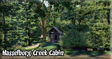
VFR Comments: Move to the North shore of the lake so you can take off safely on a heading of 230° that takes you directly to Hasselborg Creek. Only 3 miles away, first you will pass over Hasselborg Lake. On the far shore, you will see a low rocky cliff. Fly to the right end of that cliff and turn to port into Hasselborg Creek is just beyond the shoreline. Be in landing configuration as you approach that shoreline. The cabin is on the starboard shore halfway down the lake. (This lake was created by RTMM). Cabin Information: This is a very small enclosed CCC Adirondack shelter. It has a concrete floor, 1930s fireplace, wood stove and only 2 single bunks, axe and maul, table and benches, wood, cooking counter, outhouse, broom, skiff with oars. The cabin sits 10' (3 m) from the lake shore with no beach. Water is available from the lake or creek. Treat all water before using. Bring your own personal flotation devices, sleeping bags, sleeping pads, cooking stove, lantern, pots, pans, plates, utensils, food, toilet paper, garbage bags, fire extinguisher, and fire starter. Cabin users may also choose to bring a small outboard motor (less than 10 horsepower due to wilderness regulations). You are in brown bear country. Brown bear and deer may be seen in the area; good fishing can be found at the nearby lake outlet. This is 1 of 3 cabins on Hasselborg Lake (the other two are Big Shaheen and Little Shaheen). The lake is very popular and has a lot of float plane traffic. Trails to Hasselborg Creek and Guerin Lake depart from the cabin, going to the Hasselborg Lake shelter as well. The lake is 7 miles (11 km) long and part of the Cross Admiralty Canoe route. Leg 10 - Sportsman Lake USFS Cabin
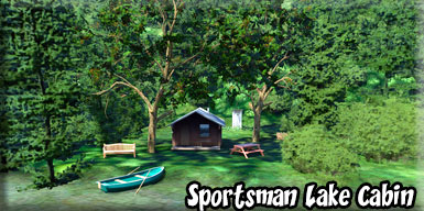
VFR Comments: Take off from Hasselborg Creek on a heading of 167° flying the length of it. At the end of the water, turn to 230° for 4.2 miles. Stay low above the terrain and be in landing configuration as you approach Sportsman Lake. the cabin is half way down the lake on the starboard shoreline. Cabin Information: This is a small hunter-style cabin that sits under a canopy of trees 200' (61 m) back from the beach.. It has sleeping space for up to 6 people. Facilities: 2 single wooden bunks, 2 double wooden bunks, Broom, Axe and maul, Wood stove, Wood, Table and benches, Outhouse, Cooking counter, Skiff with oars. Water is available from the lake. Treat all water before using. Bring your own personal flotation devices, sleeping bags, sleeping pads, cooking stove, lantern, pots, pans, plates, utensils, food, toilet paper, garbage bags, fire extinguisher, and fire starter. Please follow the oil stove directions carefully. Cabin users may also choose to bring a small outboard motor (less than 10 horsepower due to wilderness regulations). You are in brown bear country. This is 1 of 2 cabins on the lake (the other is the Distin Shelter cabin). Distin Lake is part of the Cross Admiralty Canoe route. There are 2 short portage trails on the lake and a 3-mile (5 km) trail to Thayer Lake from the other cabin. If you look carefully you will find some of the original CCC trail construction on the Thayer Lake and Davidson portages. Use at the cabin is low. A small boat at the nearby Guerin Lake shelter provides an opportunity to explore another lake. Leg 11 - Distin Lake USFS Cabin
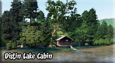
VFR Comments: The Distin Lake Cabin is only 1 mile from the Sportsman Cabin. The cabin is on a 195 ° bearing from Sportsman Cabin on the starboard shore of the lake. You can taxi this or short-hop it. Cabin Information: This is an enclosed CCC Adirondack shelter built in 1936. Original notching is visible on much of the structure. Layout is similar to a Pan Abode cabin. It has sleeping space for 2 adults and 2 children. There is NOT enough room for 4 adults. The cabin sits 30' (9 m) back from the lake with minimal beach area. Facilities: 4 single wooden bunks, wood stove, Table and benches, Broom, Cooking counter, Maul, Axe, Wood, Outhouse. Water is available from the lake. Treat all water before using. Bring your own personal flotation devices, sleeping bags, sleeping pads, cooking stove, lantern, pots, pans, plates, utensils, food, toilet paper, garbage bags, fire extinguisher, and fire starter. You are in brown bear country. This is 1 of 2 cabins on the lake (the other is the Sportsmen cabin). Distin Lake is part of the Cross Admiralty Canoe route. There are 2 short portage trails on the lake, and a 3-mile (5 km) trail to Thayer Lake begins at the cabin. If you look carefully you will find some of the original CCC trail construction as you hike the trail. This structure is currently in disrepair and not available for rent. Leg 12 - Jim's Lake USFS Cabin
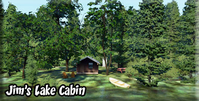
VFR Comments: Take off on a 070° heading and once off the water and safely above the terrain, come to 101° heading for Jim's Lake, 4.6 miles ahead. As you approach Jim's lake be in landing configuration, the cabin is on the shoreline you will fly over. Land and turn back to the cabin. Cabin Information: This is a typical Pan Abode cabin with a wood stove and sleeping space for 4 to 6 people. The cabin rests on a small rise adjacent to the beach with a nice overlook of the lake. Facilities: 2 single wooden bunks, 2 double wooden bunks, broom, axe and maul, wood stove, wood, table and benches, outhouse, cooking counter, skiff with oars. Water is available from the lake. Treat all water before using. Bring your own personal flotation devices, sleeping bags, sleeping pads, cooking stove, lantern, pots, pans, plates, utensils, food, toilet paper, garbage bags, fire extinguisher, and fire starter. Cabin users may also choose to bring a small outboard motor (less than 10 horsepower due to wilderness regulations). You are in brown bear country. This cabin offers the most solitude on the island. The lake is small and away from most flight paths. Leg 13 - Pybus Bay USFS Cabin
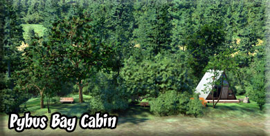
VFR Comments: Take off on a heading of 150° from Jim's Lake. Once airborne and having passed the mountain to port, turn to 144° for 14.5 miles staying above the terrain. Start gaining altitude as quickly as you can. You will pass over snow-covered mountains in 6 miles, you must be at about 3500 feet to safely clear them. As soon as you are past the mountains, drop your altitude back down to "low and slow" as you approach the water ahead. As you approach the water, you will fly over a a part of Pybus Bay. Ahead there is a point of land. Fly in approach configuration to that point and bear a little to starboard following the shoreline. You will see a cove to starboard, Pybus Bay cabin is at the far end of the cove. Cabin Information: This large A-frame cabin with a loft sits back 50 yards (46 m) up a hill from the beach. It has sleeping space for up to 7 people. Facilities:4 single wooden bunks, Sleeping loft, Cooking counter, Broom, Oil stove (uses #1 stove oil, NOT provided), Outhouse, Table and benches. Water is available from a nearby stream. Treat all water before using. Bring your own #1 stove oil, sleeping bags, sleeping pads, cooking stove, lantern, pots, pans, plates, utensils, food, toilet paper, garbage bags, fire extinguisher, and fire starter. Please follow the oil stove directions carefully. You are in brown bear country. A game trail to Donkey Bay is accessible at high tide. There is a lot of seasonal commercial fishing activity in Pybus Bay. The end of the bay has large tide flats. This is a popular cabin for hunting. Leg 14 - Church Bight USFS Cabin
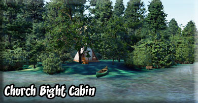
VFR Comments: Take off in the cove on a heading of 025°. At the end of the cove turn to 080°. We are going to follow the southern shore of Admiralty Island. Follow the shoreline for about 5 miles, then follow its curvature to port first to about 046°, then to 036° and finally it will turn northwest to 328°. The shoreline will come to a point. Fly around the point coming to 182° and be in landing configuration. Church Bight Cabin is on the point on the starboard shoreline 1.5 miles ahead. (This about half way into this little bay). Cabin Information: This is a large A-frame cabin with a loft and a wood stove for heat. It has sleeping space for up to 7 people. The cabin sits back 50 yards (46 m) from the beach. Facilities: 4 single wooden bunks, Sleeping loft, Wood stove, Table and benches, Cooking counter, Broom, Axe, Maul, Wood. The water source from a nearby stream is intermittent. A boat is necessary to get water from other drainages. Treat all water before using. Bring your own sleeping bags, sleeping pads, cooking stove, lantern, pots, pans, plates, utensils, food, toilet paper, garbage bags, fire extinguisher, and fire starter. You are in brown bear country. There are large tide flats within the bay. This is a popular cabin for hunting. Return to Juneau PAJN VFR Comments: As you leave Church Bight Cabin, you will be following the eastern shoreline of Admiralty island for 63 miles until you reach the Juneau area. You will be following the Stephens passage. When the passage turns to port, you can go straight ahead to the Gastineau Channel that veers to port, flying past Juneau SPB and lining up on PAJN. We hope you enjoyed the Dispatch. |
| Report any problems with this dispatch to Web master at RTMM. |
| Return to Misty Moorings Copyright 2021 |
