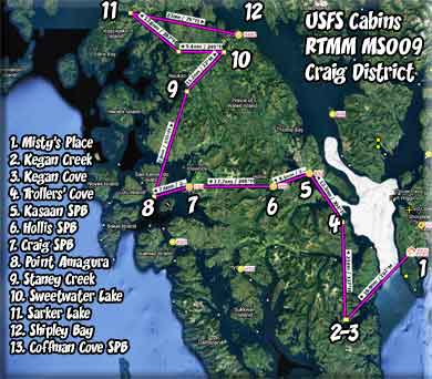
| VFR - USFS Admiralty District Cabins |
|
| Written Flight Plan |
| Download Flight Plan |
|
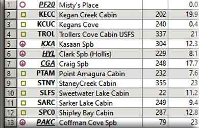
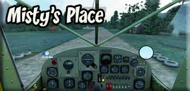
Leg 1 - Start - Misty's Place - PF20 - (Start) We are going to tour the "Craig Ranger District USFS Cabins." Our dispatch starts at Misty's Place (PF20). This is the "home base" of Return to Misty Moorings. And this is the first dispatch we have flown out of Misty's Place. Many, many more are to come. Download the flight plan for MS009 from the Manual Dispatch Table. NOTAM: You should put in the "SPB's for RTMM" mod from the RTMM website. You will see two of them on this dispatch, Kasaan, Clark SPB, Craig SPB and Coffman Cove.
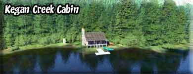
Leg 2 & 3 - Kegan Creek & Kegan Cove Cabins VFR Comments: (Safe Altitude is 1200;)From Misty's Place (PF20), we fly approximately at a 150° heading down Bostwick Inlet. When we get to its end we are flying into Nichols Passage. We turn to starboard as we enter the channel passing over the tiny Bronaugh Island with the Dall Head passing to starboard. Set a course of 220° to cross the Clarence Strait. Your target is the Moria Sound, about 15 miles ahead. You will pass over Moria Island in the center of the inlet to the sound. Begin to reduce altitude and continue straight ahead. Kegan Creek is about 7.5 miles ahead. Keep the coming shoreline to starboard, Kegan Creek will jut off to the right. You will probably fly over Kegan Creek and safely land in Kegan Lake, beyond. If you circle this area, you will see the Kegan Cove cabin on the top of a small hill (lookout cabin). On the lake, there is a small dock where you can pick up and drop off passengers for Kegan Cove. To get to Kegan Creek Cabin, go in a rough 030° heading up the creek (which is a beautiful taxi ride) and you will find the Kegan Creek Cabin on the port shoreline. It is possible to take off in this wide part of the creek if you are skillful and careful. Again, if you missed Kegan Cove cabin on the way in, do a port circle and watch for the cabin on the hill top. Then proceed on to Troller's Cove Cabin. Cabin Information Kegan Cove: 16’X18’ yellow cedar/Sitka spruce. Original cabin design by Wood Cuts, Inc. of Thorne Bay, AK. Cabin constructed on site by SAGA volunteer crew 2010. Cabin in protected cove in Moira Sound. Ocean fishing, stream fishing, viewing scenery and wildlife, beach-combing. Salmon runs draw anglers, black bear to Kegan Creek. ½-mile trail along the creek connects Kegan Cove to cabin on Kegan Creek and to Kegan Lake. Watch fish or try to catch salmon, steelhead, trout from trail. Bears, eagles, gulls and a variety of other birds frequent area. Cabin sleeps up to 6, wood stove (wood sometimes provided), outhouse. Bring your own Sleeping bags, sleeping pads, cooking stove, lantern, pots, pans, plates, utensils, food, toilet paper, garbage bags, and fire starter. It's a good idea to bring your own water. Kegan Creek: Pan Abode cedar log cabin (12'x12') on Kegan Creek near outlet of Kegan Lake. Salmon runs draw anglers, black bear to creek. ½-mile trail along the creek connects cabin to Kegan Cove and to Kegan Lake. Watch fish or try to catch salmon, steelhead, trout from trail. Bears, eagles, gulls and a variety of other birds frequent area. Cabin sleeps up to 6, Oil (#1 diesel, NOT provided), outhouse, rowboat. Bring your own #1 diesel fuel (highest setting = 0.1 gal/hour), personal flotation devices, sleeping bags, sleeping pads, cooking stove, lantern, pots, pans, plates, utensils, food, toilet paper, garbage bags, and fire starter. It's a good idea to bring your own water.
Leg 4 - Troller's Cove Cabin VFR Comments: (Safe altitude is 1200') You take off from Kegan Creek and (1) Circle to the left to get a look at the lookout cabin of Kegan Cove or (2) continue on a heading of about 094° flying out over the Moria Sound. Keep the shoreline to port, and when you come to the openness of the Clarence Strait, turn to port following the shoreline. You will pass over the large inlet to port called the Cholmondeley Sound. The well-known Dora Bay is further up this sound. Continue along the coast. Trollers Cove is 12 miles ahead. You can begin approach altitude after you have passed the Cholmondeley Sound
You will see Skin Island to starboard, continue up the coast to "Island Point" (see map above). Go around the point turning to port, and be at landing altitude. As you come around the point, there will be a cove to port and another point ahead, round the point ahead to port and you will be heading toward the cabin ... be at landing altitude!
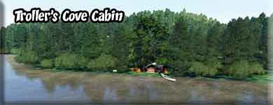
You will see a channel off to port, it is a dead end. Continue flying to the next channel straight ahead. It has a very narrow opening. Then turn to the left and follow it, the cabin is at the end of that channel (Troller's Cove). Cabin Information 14' x 14' Pan Abode cedar log cabin with small covered porch on scenic shore. Bottom fishing, salmon trolling off 20 Fathom Bank. Cove used as anchorage by commercial, pleasure boats. Numerous small lakes in hills behind cabin. Waterfalls in nearby coves. Bear, deer hunting. Spiral Cove (north) known for scenery. Cabin sleeps up to 4, wood stove (wood sometimes provided), outhouse, mooring buoy. Bring your own Sleeping bags, sleeping pads, cooking stove, lantern, pots, pans, plates, utensils, food, toilet paper, garbage bags and fire starter. It's a good idea to bring your own water.
Leg 5 - Kasaan SPB VFR Comments: (Safe Altitude is 1200') As you take off from Troller's Cove, set your heading to 304° and head direct to Kasaan SPB, about 12 miles ahead. You will see Kasaan island in the middle of the bay, just beyond it on the starboard shoreline is Kasaan SPB. The SPB is on the starboard shore of the cove. Kasaan Information: Kasaan is one of the main historical communities of the Kaigani Haida. It is the most northernly Haida settlement. Beginning in the late 1700s, European and American ships began regularly visiting and trading with Kasaan and the rest of the Haida. Most early visiting ships were part of the maritime fur trade. The nearby trading site, "Kaigani", was one of the most popular on the Pacific Northwest coast. This trade brought wealth, but also disease; the first smallpox epidemic hit Kasaan in 1794.[4] A rough census was taken of Kasaan between 1836 and 1841 by John Work of the Hudson's Bay Company. He reported 249 people living in the village. The 1862 Pacific Northwest smallpox epidemic killed over 70% of all Haida people. The first official census was taken in 1880, and lists only 173 at Kasaan. In the 1880s and 1890s, Alaska Steamship Company boats regularly visited a nearby fish saltery and packing business, and sometimes Kasaan. Tourists visiting Kasaan helped spark trade in Haida artifacts and new artwork. Residents moved from their former village on Skowl Arm (now called Old Kasaan), starting in 1893, and mostly in the period 1902–1904. In 1901, the leaders of Kasaan were persuaded by the Kasaan Bay Mining Company to relocate the entire village to a new site closer to the copper mine. This migration was prompted by the promise of jobs and a school occasioned by development of copper mining and a cannery near the present location. Kasaan was established as a city in 1976. Old Kasaan was completely abandoned by 1904, and the remains were partly destroyed by fire in 1916. The site was declared a U.S. National Monument in 1937, though it was largely neglected, and in 1955, Old Kasaan was removed from the National Park System. The site became Forest Service jurisdiction, which established a 38-acre Old Kasaan Village Historical Area in 1957,today known as Chief Son-I-Hat's Whale House and Totems Historic District.
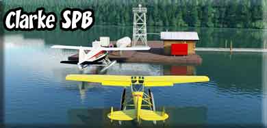
Leg 6 - Clark (Hollis) SPB VFR Comments: (Safe Altitude is 1200') Heading for Hollis. From the Kasaan SPB, set a course of 234° and fly to Clark SPB (Hollis) about 8 miles ahead. You are flying over Kasaan Inlet and heading into Twelvemile Bay. You will then fly into Clark Bay where the Clark SPB is located in the community of Hollis, AK. Land near the ferry dock and the Sea Plane parking is just ahead at the end of a long pier. Hollis Information: There were 55 households, out of which 36.4% had children under the age of 18 living with them, 60.0% were married couples living together, 3.6% had a female householder with no husband present, and 30.9% were non-families. 23.6% of all households were made up of individuals, and 12.7% had someone living alone who was 65 years of age or older. The average household size was 2.53 and the average family size was 3.00 At first, it was the only community of Prince of Wales Island to receive ferry access from the Alaska Marine Highway, but in 2002, the Marine Highway ceased service to Hollis in lieu of the new Inter-Island Ferry Authority (IFA). Now Hollis is home-port to the IFA's first ship, the M/V Prince of Wales which makes daily runs between Hollis and Ketchikan. As such, access to Ketchikan is available to Prince of Wales Island communities through the island's road network.
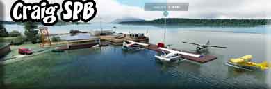
Leg 7 - Craig SPB VFR Comments: (Safe Altitude - 3500'+) Leaving Clark SPB (Hollis), fly a 247° heading for 18 miles to come to Craig SPB. There are some high hills (low mountains) ahead, fly to starboard around them and follow the low country. Continue to increase altitude to clear the snow-covered peaks ahead, if you can pick a low area, 3500' will be fine, but higher if you must. Once you clear the peaks, you may want to turn a little to port and head for the water you see in that direction. Craig SPB is beyond the mountains ahead, lowering altitude safely toward sea level. Craig Information: Craig is located on a small island off the west coast of Prince of Wales Island, and is connected by a short causeway. It is 5 miles south of Klawock, by road. It lies 56 miles northwest of Ketchikan, 750 air miles north of Seattle, 220 miles south of Juneau, and 750 air miles southwest of Anchorage. It lies at approximately 55° 28' N Latitude, 133° 09' W Longitude (Sec. 06, T074S, R081E, Copper River Meridian). The community is located in the Ketchikan Recording District. The area encompasses 6 sq. miles of land and 3 sq. miles of water. The Tlingit and Haida peoples have historically utilized the area around Craig for its rich resources. A fish saltery was built on nearby Fish Egg Island in 1907 by Craig Miller. Between 1908 and 1911, he constructed the Lyndenburger Packing Company and cold storage plant at the present site of Craig. In 1912, a post office, a school, a sawmill, and a salmon cannery were constructed. Excellent pink salmon runs contributed to the development and growth of the community through the late 1930s. During the 1950s, the fishing industry collapsed due to depleted salmon runs. In 1972, Ed Head built a large sawmill six miles from Craig near Klawock, which provided year-round jobs and helped to stabilize the economy. Head Mill was sold in the early 1990s to Viking Lumber.
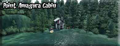
Leg 8 - Point Amagura Cabin VFR Comments: (Safe Altitude 1200') Take off from Craig SPB and set a course for 232°. This will take you to Point Amagura UFSF cabin about 8 miles ahead. You can maintain a low and slow altitude as you are over water almost all of the way. As you approach a point of land coming out from the starboard shore ahead, you are crossing the Ursua Channel. Land on the water on the near side of the point. The cabin is on the near shoreline. Cabin Information 15' x 17' metal-roofed full loft cabin located on the tip of San Fernando Island with a scenic view of the ocean and great wildlife viewing. Excellent fishing for halibut, bottom fish, pink, chum, silver and king salmon. Good hunting, beach-combing. Good place to wait out weather. Cabin sleeps up to 6 with one bunk and a loft that sleeps 4, wood stove (wood sometimes provided), axe, maul, wedges, outhouse. Bring your own water (none available near cabin), sleeping bags, sleeping pads, cooking stove, lantern, pots, pans, plates, utensils, food, toilet paper, garbage bags, fire starter. Wood is not guaranteed.
Leg 9 - Staney Creek Cabin VFR Comments: (Safe Altitude is 2000') Leaving Point Amagura Cabin, set a heading of 355° for 23 miles to come to Staney Creek USFS Cabin. On this course you will first cross over San Fernando Island (the home island of Point Amagura. Then you will cross over the San Cristoval Channel. The large island ahead is the Prince of Wales Island. You can maintain 2000' altitude if you go to port around the mountains on the far side of Prince of Wales, the cabin is beyond those low mountains. This is one of the few cabins that you can land in a tundra configurated aircraft. But there is a dock for watercraft. You will fly over Naukati Bay as you turn slightly to starboard after the low mountains. On the starboard side of Naukati Bay, you will see a group of small islands. Go into landing formation and turn to starboard, about 062° degrees and watch for Staney creek veering off to starboard. You will see a large meadow on the far side of the creek, the cabin is there near the tree line. Watch for creeks and other estuaries as you find a safe ground landing ... or land on the creek near the dock. Cabin Information 12' x 12' Pan Abode log cabin with covered porch located on mouth of Staney Creek and large estuary. Huge old-growth spruce, hemlock, cedar; large tidal meadow of tall grass at mouth of creek. Cutthroat trout, rainbow trout, dolly Varden, 4 species of salmon. Ducks, geese along Staney Creek and tidal flats. Bald eagles, gulls and other shore birds in tidal zone. Black bear, Sitka black-tailed deer. Half-mile hike to cabin from parking area on boardwalk. Cabin sleeps up to 6. Oil stove (bring your own #1 diesel/fuel oil), outhouse. Bring your own Sleeping bags, sleeping pads, cooking stove, lantern, pots, pans, plates, utensils, food, toilet paper, garbage bags and fire starter. It's a good idea to bring your own water.
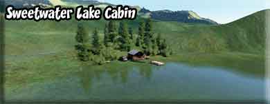
Leg 10 - Sweetwater Lake Cabin VFR Comments: (Safe Altitude 1500') Take off from Staney Creek Cabin and come to a heading of 02 for 11.2 miles. You will see Sweetwater Lake ahead. The cabin is on the starboard shoreline You will see an island, fly past the island in landing configuration and the cabin is ahead on the coming shoreline. Cabin Information: 12' x 14' Pan Abode log cabin with covered porch on the edge of lake Sweetwater with large gravelly beach, surrounded by old-growth spruce, hemlock, and cedar forest. Good fishing for rainbow trout, cutthroat trout, Dolly Varden as well as coho, sockeye, and pink salmon. Migratory waterfowl in fall. Sitka black-tailed deer, black bear, marten, mink, otter, beaver common. Seals often seen in lake. Cabin sleeps up to 6, wood stove (wood sometimes provided), outhouse, rowboat. Bring your own stove fuel (#1 diesel, uses 0.2 gal/hour at highest setting), Personal flotation devices, sleeping bags, sleeping pads, cooking stove, lantern, pots, pans, plates, utensils, food, toilet paper, garbage bags and fire starter. It's a good idea to bring your own water. Please take your fuel container with you when you leave. The Forest Service suggests that you not use the water from these streams for drinking water due to low PH and metal concentrations.
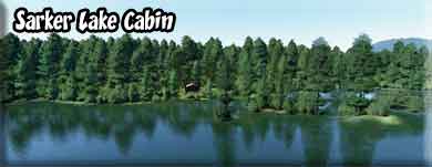
Leg 11 - Sarker Lake Cabin VFR Comments: (Safe Altitude is 1200') Take off from Sweetwater Lake and come to a heading of 250° for about 9 miles. You will be heading toward a low mountain, fly around it keeping it on your port side as you gain altitude. You can stay at 1200' if you do this. After you come around the mountain, set a course of 247°, the cabin is 6.2 miles ahead. You will fly over a large lake, then beyond it is Sarker Lake. There are many little islands. The cabin is on the far shoreline to the right of the islands. As you approach, there are 2 very tiny islands off the starboard shore, the cabin is just beyond them on the right. Cabin Information: 12' x 12' Pan-Abode precut cedar log cabin with large covered porch hidden in the forest on Sarkar Lake. Surrounding scenery characteristic of temperate rain forest. Old growth forest towers over muskegs, lakes and streams. Area has rich cultural history of Native American settlements, fox farming, extensive trapping. Sarkar Canoe Route begins on Sarkar Lake, goes 15 miles (24 km) into backcountry with several portages connecting 7 lakes with high quality fishing. Trumpeter swans in fall and spring. Large parking area, boat ramp and toilet at t railhead. Skiffs provided for cabin users, one at boat ramp and one at cabin. Take care when boating, numerous rocks in lake. Good marine chart recommended. Cabin sleeps up to 6, wood stove, outhouse, rowboat. Bring your own personal flotation devices, sleeping bags, sleeping pads, cooking stove, lantern, pots, pans, plates, utensils, food, toilet paper, garbage bags and fire starter. It's a good idea to bring your own water. Wood is not provided regularly at this site. Come prepared to provide your own (do not cut down trees near cabin). Compressed fire bricks are available for purchase at several locations on Price of Wales; call Craig Ranger District for more information. The Sarkar area on Price of Wales Island now has something for everyone; a day use site, a cozy cabin and a canoe route. In 2015, road paving was completed and so was the Sarkar Recreation Area day use site. The site boasts a large covered pavilion, new outhouse, expanded parking, ramp to the lake's edge for easier access, and a fire ring with outdoor seating (wood not provided).
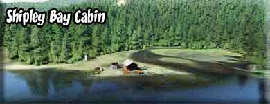
Leg 12 - Shipley Bay Cabin VFR Comments: (Safe Altitude is 1600' VFR) Go back out in the lake, you will be flying over the Sarker Lake Cabin on a heading of 287° for almost 13 miles to get to Shipley Bay. As you approach a bank of mountains, follow the water to port on a course of about 240° keeping the mountains to starboard and circling around them to the right. Its a little further, but you can maintain a low altitude. You will see a large inlet going off to starboard, follow that inlet inland. At the end of the inlet, you can fly over a low hump of land, and ahead of you is Shipley Bay. Turn a little to starboard to a heading of 345°. The cabin is on the far starboard shore where you see an inlet. You will see a large vertical rock "scar" on the mountain, the cabin is on the shoreline beneath that feature. Cabin Information: 12' x 14' Pan Abode precut cedar log cabin with covered porch on the shore of Shipley Bay offering excellent mountain views and wildlife watching. Mount Francis ( picturesque 2,592-foot limestone peak) visible from cabin. Cabin sits on low bluff between bay and creek. Large rocky beach in front of cabin, large grassy tidal flat in back where Shipley Creek meets ocean. Rugged 0.8-mile natural-tread trail connects to Shipley Lake. Can continue hiking lower elevation route to Devilfish Bay (no designated trail). Good maps and orienteering skills essential. Stream and lake support cutthroat, rainbow, dolly Varden, steelhead, three species of salmon. Black bears, bald eagles, shore birds abundant. Cabin sleeps up to 6, tiny wood stove which accommodates BioBricks (usually readily available from local retailers). Bring your own BioBlocks, water, sleeping bags, sleeping pads, cooking stove, lantern, pots, pans, plates, utensils, food, toilet paper, garbage bags and fire starter.
Leg 13 - Coffman Cove SPB VFR Comments: (Safe Altitude is 1500') Take off from Shipley Bay Cabin on a heading of 79° and fly through the gap in the mountains keeping the cabin to port as you fly over it. You will fly over Shipley Lake. The lake bears to starboard, follow the curve and you will see a low spot on the far shore, fly over that. You will then fly over a tiny lake and you will see a valley going off to port. Follow that valley to the inlet called Devilfish Bay. Fly along the inlet. Coming out of the inlet, set a heading of 068° and you will arrive over Neck Lake. Fly to the end of the lake and set a course direct to Coffman Cove SPB on a heading of 092°. You may see the Prince of Wales lodge just off the port wing on the water. You will find the Coffman Cove SPB on the port shoreline on your heading. Land and taxi up to the parking area. Well done! We hope you enjoyed the Dispatch. Coffman Cove Information: Coffman Cove is a busy charter fishing port for a reason! Salmon and halibut abound in Clarence Strait near Coffman Cove. Go fly fishing with a knowledgeable guide. There are several streams near Coffman Cove where the fly fishing is great!A variety of local VRBO cabins will give you time and space to enjoy the small-town good life. Bring your paddle boat and explore! There is easy access to saltwater at the downtown boat launch ramp, and an improved access to Luck Lake.
|
| Report any problems with this dispatch to Web master at RTMM. |
| Return to Misty Moorings Copyright 2021 |