

| Navigation Page Index |
|
| WayPoint Table | |||||||
| WayPoint Table (Starting Points for All RTMM Locations) | |||||||
 |
Every Location in RTMM is listed on the WayPoint table below. If you position your aircraft at the postion for the location, you will be ready for flight from that location. |
||||||
Location Name |
Name of location as it is listed on the Scenery Page,. |
||||||
| Lat/Long | GPS Coordinates | ||||||
| Head | Direction to set your vehicle for proper startup heading | ||||||
| Pkg | Group Identifier | ||||||
| Surf | Type of landing zone, water, ice, land, heli, etc. | ||||||
| HF | Helicopter Friendly (a nearby place to land a helicopter is available) | ||||||
| IOAC | Identifier for location | ||||||
| Back to Top | |||||||
| Click on a Letter to Navigate Alphabetically or Scroll Down to Browse |
| A B C D E F G H I J K L M N O P Q R S T U V W X Y Z |
| |
| - A - | |||||
Location Name |
Latitude/Longitude |
Head |
Pkg |
Surf | ICAO |
| Active Pass Lighthouse | 48.87370, -123.29213 | 015° | LITEBC | Water | APLH |
| Active Pass Lighthouse (H) | 54.80317,-130.93614 | 015° | LITEBC | Helo | APLH |
| Addenbroke Island Lighthouse | 51.60324, -127.86481 | 157° | LITEBC | Water | AIL1 |
| Addenbroke Island Lighthouse (H) | 51.604463, -127.86363 | 110° | LITEBC | Heli | AIL1 |
| Admiralty Cove Cabin (W) | 58.17766, -134.56981 | 100° | USFS3 | Water | ADMC |
| Admiralty Cove Cabin (L) | 58.17526, -134.56442 | 360° | USFS3 | Tundra | ADMC |
| Admiralty Cove Cabin (H) | 58.175935, -134.56381 | 017° | USFS3 | Heli | ADMC |
| Alava Bay Cabin | 55.22399, -131.15395 | 217° | USFS1 | Water | ALAV |
| Alava Bay Cabin (H) | 55.22374, -131.15575 | 033° | USFS1 | Land | ALAV |
| Alexander Lake Cabin | 57.66965, -134.18483 | 320° | USFS3 | Water | ALEX |
| Alexander Lake Cabin (H) | 57.671122, -134.1829 | 207° | USFS3 | Heli | ALEX |
| Allan Point Cabin | 57.24211, -135.39918 | 297° | USFS12 | Water | ALLP |
| Allan Point Cabin (H) | 57.241697 ,-135.400511 | 023° | USFS12 | HEli | ALLP |
| Amphritite Point Lighthouse | 48.920871, -125.54275 | 051° | LITEBC | Water | AMLH |
| Amphritite Point Lighthouse (H) | 48.92239, -125.54161 | 017° | LITEBC | Heli | AMLH |
| Annette Island PANT (H) | 55.03733,-131.5775 | 226° | Helipads | Heli | PANT |
| Alsek River Cabin | 59.19915, -138.45151 | 039° | USFS11 | Water | A57 |
| Alsek River Cabin (H) | 59.19912, -138.452033 | 044° | USFS11 | Heli | A57 |
| Anan Bay Cabin | 56.18786, -131.88984 | 137° | USFS9 | Water | ANA1 |
| Anan Lake Cabin | 56.12532, -131.88664 | 142° | USFS9 | Water | ANA2 |
| Anchor Pass Cabin | 55.97358, -131.39600 |
059° | USFS1 | Water | ANCP |
| Angoon SPB | 57.49619, -134.56742 | 270° | SPBJDL | Water | AGN |
| Angoon SPB | 57.49572, -134.56935 | 265° | SPBJDL | Heli | AGN |
| Appleton Cove Cabin | 57.47196, -135.26329 | 170° | USFS12 | Water | APPL |
| Appleton Cove Cabin (H) | 57.471749, -135.264205 | 081° | USFS12 | Heli | APPL |
| Aspen Flats Cabin | 60.36925, -149.97517 | 060° | USFS5 | Water | ASPN |
| Aspen Flats Cabin | 60.369500, -149.973921 | 230° | USFS5 | Heli | ASPN |
| Avoss Lake Cabin | 56.70305, -134.92682 | 024° | USFS12 | Water | AVOS |
| Avoss Lake Cabin (H) | 56.702813, -134.926038 | 325° | USFS12 | Heli | AVOS |
| Back to Top of WayPoint Table | |||||
| - B - | |||||
Location Name |
Latitude/Longitude |
Head |
Pkg |
Sur | IOAC |
| Bakewell Lake Cabin | 55.26080, -130.6697 | 130° | USFS1 | Water | BAKE |
| Ballenes Islands Lighthouse | 49.3500, -124.16225 | 180° | LITEBC | Water | BIL1 |
| Ballenes Islands Lighthouse (H) | 49.35021, -124.15992 | 309° | LITEBC | Heli | BIL1 |
| Baranof Lake Cabin | 57.08651, -134.8635 | 165° | USFS12 | Water | BARAA |
| Barber Cabin | 60.437594, -149.9871 | 107° | USFS5 | Water | BAR1 |
| Bartlett Cove SPB | -58.45383,-135.8878 | 041° | PADS | Water | BQV |
| Bartlett Cove SPB (H) | 58.45427,-135.88757 | 125° | PADS | Heli | BQV |
| Barnes Lake Cabin | 56.01246, -132.9749 | 279° | USFS8 | Water | BQD |
| Barnes Lake Cabin (H) | 56.013555, -132.974997 | 181° | USFS8 | Heli | BQD |
| Beach River Cabin | 60.018675, -147.38104 | 258° | USFS5 | Water | BEA1 |
| Beach River Cabin (H) | 60.019080, -147.38142 | 106° | USFS5 | Heli | BEA1 |
| Beaver Pond Strip - Chugach | 61.3116176, -148.58534 | 288° | CHUG | Land | CH11 |
| Beecher Pass Cabin | 56.58439, -133.0502 | 208° | USFS7 | Water | BEEP |
| Bell Island Hot Springs | 55.92907, -131.57227 | 342° | SPBJDL | Water | KBE |
| Bell Island Hot Springs (H) | 55.92897,-131.57281 | 304° | SPBJDL | Heli | KBE |
| Berg Bay Cabin | 56.36388, -132.0070 | 360° | USFS9 | Water | BERG |
| Berg Bay Cabin (H) | 56.363764, -132.006419 | 312° | USFS7 | Water | BERG |
| Berners Bay Cabin | 58.76982, -134.9333 | 072° | USFS6 | Water | BERN |
| Berners Bay Cabin (H) | 58.7692246, -134.934275 | 029° | USFS6 | Heli | BERN |
| Big Goat Lake Cabin | 55.53413, -130.6038 | 144° | USFS1 | Water | BGLC |
| Big Goat Lake Cabin (H) | 55.532966, -130.60249 | 381° | USFS1 | Heli | BGLC |
| Big John Bay Cabin | 56.84430, -133.6887 | 055° | USFS7 | W/T | BJBC |
| Big Shaheen Cabin | 57.70027, -134.2750 | 340° | USFS3 | Water | BSUC |
| Big Shaheen Cabin (H) | 57.700711, -134.27479 | 243° | USFS3 | Heli | BSUC |
| Big Timber Creek Airstrip | 61.4248134, -148.67590 | 168° | CHUG | Land | CH06 |
| Biorka Island Dock | 56.85559, -135.5210 | 160° | Docks A | Water | TF03 |
| Biorka Island (H) | 56.85539,-135.52136 | 254° | Docks A | Heli | TF02 |
| Black Bear Lake Cabin | 55.54038, -132.8581 | 132° | USFS8 | Water | BBLC |
| Black Bear Lake Cabin (H) | 55.539799, -132.858636 | 042° | USFS8 | Heli | BBLC |
| Blind Pass Cabin. | 55.89317, -131.6504 | 128° | USFS1 | Water | BPUC |
| Boat Bluff Lighthouse | 52.64312, -128.52439 | 298° | LITEBC | Water | BBLS |
| Boat Bluff Lighthouse (H) | 52.643740, -128.5245 | 041° | LITEBC | Heli | BBLS |
| Bohemia Basin Shelter | 57.98654, -136.3782 | 272° | USFS10 | Water | BOHB |
| Bohemia Basin Shelter (H) | 57.985993, -136.379466 | 012° | USFS10 | Heli | BOHB |
| Bonilla Island Lighthouse | 53.49324, -130.6357 | 288° | LITEBC | Water | BILH |
| Bonilla Island Lighthouse (H) | 53.49297,-130.63528 | 244° | LITEBC | Heli | BILH |
| Brent's Beach Cabin | 57.13822, -135.5641 | 201° | USFS12 | Water | BREC |
| Bridge Bar - Chugach | 61.5081944, -149.0275027 | 331° | CHUG | Land | CH02 |
| Brent's Beach Cabin (H) | 57.137563, -135.564324 | 287° | USFS12 | Heli | BREC |
| Brieland Slough | 56.63806, -133.1608 | 046 | USFS7 | Water | BRIC |
| Brockton Point Lighthouse | 49.300157, -123.11639 | 281° | LITEBC | Water | BPLH |
| Brockton Point Lighthouse (H) | 49.30053,-123.11717 | 275° | LITEBC | Heli | BPLH |
| Back to Top of WayPoint Table | |||||
| - C - | |||||
Location Name |
Latitude/Longitude |
Head |
Pkg |
Sur | IOAC |
| Cape Beale Lighthouse | 48.787644, -125.21306 | 310° | LITEBC | Water | CBL1 |
| Cape Beale Lighthouse (H) | 48.787393, -125.21595 | 128° | LITEBC | Heli | CBL1 |
| Cape Decision Dock | 56.001939 -134.135589 | 350° | Docks A | Water | TF01 |
| Cape Decision (H) | 56.01046, -134.13997 | 332° | Docks A | Heli | TF01 |
| Cape Hitchenbrook Lighthouse | 60.236772, -146.64777 | 031° | LITEAK | Water | CHLI |
| Cape Hitchenbrook Lighthouse (H) | 60.237335, -146.64664 | 023° | LITEAK | Heli | CHLI |
| Cape Mudge Lighthouse | 49.998440, -125.19613 | 134° | LITEBC | Water | MUl1 |
| Cape Mudge Lighthouse (H) | 49.998452, -125.19511 | 039° | LITEBC | Heli | MUL1 |
| Cape Sarichef Airport | 54.587549, -164.90833 | 196° | LITEAK | Ramp | PACS |
| Cape Sarichef Airport (H) | 54.587825, -164.9082 | 261° | LITEAK | Heli | PACS |
| Cape Sarichef Lighthouse | 54.596500, -164.92866 | 350° | LITEAK | Water | CSLH |
| Cape Sarichef Lighthouse (H) | 54.598687, -164.92599 | 079° | LITEAK | Heli | CSLH |
| Cape Scott Lighthouse | 50.78333, -128.42140 | 317° | LITEBC | Water | CSL1 |
| Cape Scott Lighthouse (H) | 50.78188, -128.42741 | 288° | LITEBC | Heli | CSL1 |
| Cape Spencer Lighthouse | 58.20004, -136.63991 | 175° | LITEAK | Water | CPSL |
| Cape Spencer Lighthouse (H) | 58.19930, -136.64012 | 161 | LITEAK | Heli | CPSL |
| Cape St Elias Lighthouse | 59.798572, -144.60250 | 073° | LITEAK | Water | CPEL |
| Cape St Elias Lighthouse (H) | 59.797868, -144.59938 | 058° | LITEAK | Heli | CPEL |
| Caribou Creek Cabin (H) | 62.614531, -143.46407 | 160° | USFS5 | Heli | CCR1 |
| Carmanah Point Lighthouse | 48.611288, -124.74974 | 284° | LITEBC | Water | CPLS |
| Carmanah Point Lighthouse (H) | 48.611988, -124.75180 | 349° | LITEBC | Heli | CPLS |
| Cascade Creek Cabin | 56.99665, -132.7848 | 130° | USFS7 | Water | CCUC |
| Castle Flats Cabin | 56.64670, -133.2504 | 134° | USFS7 | Water | CFUC |
| Castle River Cabin | 56.64314 ,-133.2583 | 317° | USFS7 | Water | CARC |
| Chatham Point Lighthouse | 50.332411, -125.44342 | 172° | LITEBC | Water | CHAT |
| Chatham Point Lighthouse (H) | 50.33332,-125.44535 | 048° | LITEBC | Heli | Chat |
| Checats Lake Cabin | 55.48788, -130.8255 | 260° | USFS1 | Water | CCAT |
| Checats Lake Cabin (H) | 55.487305, -130.82571 | 319° | USFS1 | Heli | CCAT |
| Chrome Island Lighthouse | 49.209002, -123.80932 | 082° | LITEBC | Water | CILS |
| Chrome Island Lighthouse (H) | 49.209002, -123.80932 | 082° | LITEBC | HELI | CILS |
| Church Bight Cabin | 57.42588, -133.9258 | 220° | USFS3 | Water | CHBU |
| Coal Harbour SPB | 59.60623, -151.4155 | 331° | SPBJJ | Water | PACP |
| Coal Harbour SPB (H) Helipad #1 | 59.60127,-151.41452 | 330° | Helipads | Heli | PACP |
| Coal Harbour SPB (H) Helipad #2 | 59.60477,-151.41779 | 330° | Helipads | Heli | PACP |
| Coffman Cove SPB | 56.01628, -132.8351 | 020° | SPBJDL | Water | PAKC |
| Coffman Cove (H) | 56.01554 -132.83339 | 053 | SPBJDL | Heli | PAKC |
| Coghill Lake Cabin | 61.075092, -147.87912 | 132° | USFS5 | Water | CHL1 |
| Coghill Lake Cabin (H) | 61.074835, -147.87940 | 344° | USFS5 | Heli | CHL1 |
| Control Lake Cabin | 55.69373, -132.8654 | 357° | USFS8 | Water | CONL |
| Contol Lake Cabin (H) | 55.694612, -132.865769 | 113° | USFS8 | Heli | CONL |
| Corner Bay Dock | 57.73712, -135.1356 | 341° | Docks A | Water | TF02 |
| Corner Bay Dock | 57.73664,-135.13667 | 253° | Docks A | Heli | TF02 |
| Craig SPB | 55.48915, -133.1425 | 130° | SPBJDL | Water | CGA |
| Craig SPB (H) | 55.48903, -133.14127 | 088° | SPBJDL | Heli | CGA |
| Crescent Lake Cabin | 60.476077, -149.5745 | 281° | USFS5 | Water | CRL1 |
| Crescent Lake Cabin (H) | 60.476863, -149.57420 | 140° | USFS5 | Heli | CRL1 |
| Crossway E Airstrip-Chugach | 61.257934, -148.58142 | 315° | CHUG | Land | CH16 |
| Crow Pass Cabin (H) | 61.054897, -149.11514 | 138° | USFS5 | Heli | CRP1 |
| Back to Top of WayPoint Table | |||||
| - D - | |||||
Location Name |
Latitude/Longitude |
Head |
Pkg |
Sur | IOAC |
| Dale Clemens Cabin (H) | 60.194339, -149.4153 | 037° | USFS5 | Heli | DCL1 |
| Dan Moller Cabin | 58.262294, -134.45979 | 124° | USFS6 | Land | DMUC |
| Dan Moller Cabin (H) | 58.2621221, -134.459984 | 049° | USFS6 | Heli | DMUC |
| Davidof Lake Cabin | 56.61955, -134.8387 | 335° | USFS12 | Water | DLUC |
| DeBoer Lake Cabin | 55.33871, -131.6424 | 295° | USFS7 | Water | DBUC |
| Deep Bay Cabin | 56.39404, -132.6409 | 112° | USFS9 | Water | DEP1 |
| Deep Bay Cabin (H) | 56.393669, -132.641644 | 191° | USFS9 | Heli | DEP1 |
| Denver Caboose Cabin | 59.50198, -135.2299 | 162° | USFS6 | Heli | DNCC |
| Devils Elbow Cabin | 56.64532, -133.7220 | 182° | USFS7 | Water | DEVE |
| Devils Pass Cabin (H) | 60.621110, -149.75198 | 252° | USFS5 | Heli | DVL1 |
| Discovery Island Lighthouse | 48.425019, -123.22402 | 240° | LITEBC | Water | DIS1 |
| Discovery Island Lighthouse (H) | 48.424408, -123.22551 | 304° | LITEBC | Heli | DIS1 |
| Distin Lake Cabin | 57.63055, -134.3990 | 220° | USFS3 | Water | DIST |
| Double Bay Cabin | 60.466027, -146.442853 | 022° | USFS5 | Water | DBC1 |
| Dryad Point Lighthouse | 52.183786, -128.11288 | 028° | LITEBC | Water | DPLS |
| Dryad Point Lighthouse (H) | 52.18478,-128.11264 | 298° | LITEBC | Heli | DPLS |
| Back to Top of WayPoint Table | |||||
| - E - | |||||
Location Name |
Latitude/Longitude |
Head |
Pkg |
Sur | IOAC |
| Eagle Cabin | 59.55469, -139.51121 | 226° | USFS11 | Tundra | A68 |
| Eagle Glacier Cabin | 58.57289 -134.74890 | 237° | USFS6 | Water | EAGC |
| Eagle Lake Cabin | 56.06043, -131.46756 | 069° | USFS9 | Water | EAG1 |
| East Creek Cabin (H) | 60.706961, -149.748325 | 175° | USFS5 | Heli | ECC1 |
| East Florence Lake Cabin | 57.81221, -134.58400 | 370° | USFS3 | Water | EFUC |
| East Florence Lake Cabin (H) | 57.81177, -134.58518 | 058° | USFS3 | Heli | EFUC |
| East Point Lighthouse | 48.78476, -123.04438 | 240° | LITEBC | Water | EPL1 |
| East Point Lighthouse (H) | 48.7849,-123.0449 | 183 | LITEBC | Heli | EPL1 |
| East Turner Lake Cabin | 58.31221 -133.79198 | 009° | USFS6 | Water | ETUC |
| Edna Bay Dock | 55.96309, -133.62251 | 150° | Docks A | Water | TF04 |
| Edna Bay Dock (H) | 55.96294, -133.62094 | 079° | Docks A | Heli | TF04 |
| Egg Island Lighthouse | 51.249754, -127.83725 | 157° | LITEBC | Water | EIL1 |
| Egg Island Lighthouse (H) | 51.249695, -127.83645 | 079° | LITEBC | Heli | EIL1 |
| Eight Fathom Cabin | 58.00098, -135.77180 | 044° | USFS10 | Water | EFU1 |
| El Capitan Lodge | 55.95835, -133.25793 | 100° | S.A. | Water | 5C5 |
| Eldred Rock Lighthouse | 58.97133, -135.22267 | 032° | LITEAK | Water | ERLS |
| Eldred Rock Lighthouse (H) | 58.971774, -135.22193 | 117° | LITEAK | Heli | ERLS |
| Elfin Cove SPB (Dock 2 Outside) | 58.19487,-136.34729 | 117° | SPBJDL | Water | PAEN |
| Elfin Cove SPB (Dock1 Inside) | 58.1903,-136.34216 | 310° | SPBJDL | Water | PAEN |
| Elfin Cove SPB (H) | 58.19049,-136.34138 | 342° | SPBJDL | Heli | PAEN |
| Ella Narrows Cabin | 55.48898, -131.08992 | 292° | USFS1 | Water | ELLA |
| Ella Narrows Cabin (H) | 55.48933,-131.09329 | 059° | USFS1 | Heli | ELLA |
| Entrance Island Lighthouse | 49.208567, -123.80848 | 052° | LITEBC | Water | EILS |
| Entrance Island Lighthouse (H) | 49.20900, -123.80932 | 067° | LITEBC | Heli | EILS |
| Estevan Point Lighthouse | 49.38201, -126.54447 | 258° | LITEBC | Water | ESL1 |
| Estevan Point Lighthouse | 49.38257, -126.54443 | 014° | LITEBC | Heli | ESL1 |
| Excursion Inlet SPB | 58.41672,-135.44716 | 308 | SPBJDL | Water | EXI |
| Excursion Inlet SPB (H) | 58.41904,-135.4469 | 059 | SPBJDL | Heli | EXI |
| Back to Top of WayPoint Table | |||||
| - F - | |||||
Location Name |
Latitude/Longitude |
Head |
Pkg |
Sur | IOAC |
| Fairway Island Light | 57.442541, -134.87042 | 233° | LITEAK | Water | FILH |
| Fairway Island Light (H) | 57.44289,-134.87135 | 233° | LITEAK | Heli | FILH |
| Fisgard Lighthouse | 48.430734, -123.44785 | 205° | LITEBC | Water | FIL1 |
| Fisgard Lighthouse (H) | 48.43088,-123.44736 | 237° | LITEBC | Heli | FIL1 |
| Fish Creek Cabin | 55.39218, -131.19518 | 294° | USFS1 | Water | FSRK |
| Five Finger Lighthouse | 57.27056, -133.63023 | 217° | Docks A | Water | TF05 |
| Five Finger Light (H) | 57.27461, -133.62767 | 302° | Docks A | Heli | TF05 |
| Fox Creek Cabin (H) | 60.73416, -149.704913 | 121° | USFS5 | Heli | FCC1 |
| Frederick Pt VOR | 56.7925,-132.81992 | 314° | Docks A | Water | TF06 |
| Frederick Pt VOR (H) | 56.79213, -132.82152 | 225° | Docks A | Heli | TF06 |
| Fred's Creek Cabin | 57.06382, -135.60347 | 264° | USFS12 | Water | FRED |
| Fred's Creek Cabin (H) | 57.064197, -135.604666 | 274° | USFS112 | Heli | FRED |
| Frosty Bay Cabin | 56.05865, -131.96500 | 201° | USFS9 | Water | FBUC |
| Funter Bay SPB Dock | 58.25568, -134.89749 | 269° | SPBJDL | Water | PANR |
| Funter Bay SPB Heli | 58.25446,-134.89882 | 342° | SPBJDL | Heli | PANR |
| Back to Top of WayPoint Table | |||||
| - G - | |||||
Location Name |
Latitude/Longitude |
Head |
Pkg |
Sur | IOAC |
| Garnet Ledge Cabin | 56.57451, -132.36704 | 039° | USFS9 | Water | GLUC |
| Garnet Ledge Cabin (H) | 56.574108, -132.366158 | 320° | USFS9 | Heli | GLUC |
| George Inlet Cannery | 55.38457, -131.46910 | 349° | S.A | Water | GINC |
| George Inlet Cannery (H) | 55.38360 , -131.47170 | 083° | S.A | Heli | GINC |
| George Inlet Lodge | 55.36545, -131.47395 | 164° | S.A. | Water | GINT |
| George Inlet Lodge (H) | 55.365491, -131.47398 | 255° | S.A. | Heli | GINT |
| Glacier Lake Airstrip-Chugach | 61.175944, -148.73328 | 005° | CHUG | Land | CH19 |
| Gold River SPB | 49.67852, -126.11651 | 328° | SPB-JJ | Water | CAU6 |
| Gold River SPB (H) | 49.67905,-126.11736 | 328° | Helipad | Heli | CAU6 |
| Goose Bay Cabin | 60.714791, -148.224790 | 080° | USFS5 | Water | GBC1 |
| Green Island Lighthouse | 54.568472, -130.7095 | 352° | LITEBC | Water | GILS |
| Green Island Lighthouse (H) | 54.568550, -130.70644 | 259° | LITEBC | Heli | GILS |
| Goulding Lake Cabin | 57.81713, -136.15456 | 338° | USFS12 | Water | GOUC |
| Granite Creek Campground (H) | 60.726625, -149.3017 | 124° | USFS5 | Heli | GGC1 |
| Grasshopper Strip - Chugach | 61.416061, -148.317910 | 309° | CHUG | Land | CH10 |
| Green Bar Airstrip -Chugach | 61.238669, -148.64260 | 314° | CHUG | Land | CH17 |
| Green Island Cabin | 60.287961, -147.3955244 | 252° | USFS5 | Water | GIC1 |
| Green Island Cabin (H) | 60.288243, -147.39512 | 332° | USFS5 | Heli | GIC1 |
| Greentop Cabin | 57.86540, -136.45027 | 088° | USFS10 | Water` | GTOP |
| Guard Island Lighthouse | 55.445675, -131.87951 | 211° | LITEAK | Water | GUAR |
| Guard Island Lighthouse (H) | 55.445966, -131.87993 | 255° | LITEAK | Heli | GUAR |
| Gustavus Airport Helipad (H) | 58.42227,-135.7039 | 210 | Helipads | Heli | PAGS |
| Gut Island Cabin 1 | 56.61171, -132.48900 | 011° | USFS9 | Tundra | GUT1 |
| Gut Island Cabin 1 (H) | 56.611964, -132.488274 | 239° | USFS9 | Heli | GUT1 |
| Gut Island Cabin 2 | 56.61224, -132.48490 | 338° | USFS9 | Tundra | GUT2 |
| Gut Island Cabin 2 | 56.612872, -132.484641 | 193° | USFS9 | Heli | GUT2 |
| Back to Top of WayPoint Table | |||||
| - H - | |||||
Location Name |
Latitude/Longitude |
Head |
Pkg |
Sur | IOAC |
| Haines SPB by RTMM | 59.23456,-135.44044 | 246° | SPBJDL | Water | 3Z91 |
| Haines SPB by RTMM (Heli) | 59.23515,-135.44099 | 255° | SPBJDL | Heli | 3Z91 |
| Harding River Cabin | 56.20242, -131.61588 | 294° | USFS9 | Water | HBC1 |
| Harding River Cabin (H) | 56.202141, -131.616672 | 358° | USFS9 | Heli | HBC1 |
| Harlequin Lake Cabin | 59.41775, -139.01202 | 131° | UFSF11 | Water | A67C |
| Hartley Bay SPB | 53.42246, -129.25089 | 302° | SPB-JJ | Water | CAY4 |
| Hartley Bay SPB (H) | 53.42344,-129.25287 | 246° | Helipads | Heli | CAY4 |
| Harrison Lagoon Cabin | 60.984805, -148.200553 | 075° | USFS5 | Water | HLC1 |
| Harrison Lagoon Cabin (H) | 60.98472, -148.199549 | 284° | USFS5 | Heli | HLC1 |
| Harvey Lake Cabin | 56.56438, -133.05811 | 288° | USFS7 | Water | HARV |
| Hasselborg Creek Cabin | 57.65801, -134.25191 | 270° | USFS3 | Water | HASS |
| Hawk Inlet SPB | 58.12547,-134.75671 | 234° | SPBJDL | Water | HWI |
| Hawk Inlet SPB (H) | 58.12535,-134.75633 | 326° | SPBJDL | Heli | HWI |
| Heckman Lake Hatchery (dock 2) | 55.57232, -131.51311 | 090° | USFS1 | Water | HECK |
| Heckman Lake Hatchery (H) | 55.572058, -131.51290 | 065° | USFS1 | Heli | HECK |
| Heckman Lake Cabin N | 55.58485, -131.54077 | 171° | USFS1 | Water | HEC2 |
| Heckman Lake Cabin S | 55.57531, -131.52682 | 252° | USFS1 | Water | HEC1 |
| Helm Bay Cabin | 55.62906, -131.97705 | 200° | USFS1 | Water | HBUC |
| Helm Creek Cabin | 55.65178, -131.97911 | 197° | USFS1 | Water | HCUC |
| Holland Rock Lighthouse | 54.172527, -130.36079 | 158° | LITEBC | Water | HRL1 |
| Holland Rock Lighthouse (H) | 54.17266, -130.36123 | 162° | LITEBC | Heli | HRL1 |
| Hollis (Clark) SPB - HYL | 55.49014, -132.62502 | 044° | SPBJDL | Water | HYL |
| Hollis SPB (H) | 55.49099, -132.62251 | 342° | SPBJDL | Heli | HYL |
| Honker Lake Cabin | 55.83388, -132.88863 | 055° | USFS4 | Water | HONK |
| Hook Point Cabin | 60.345030, -146.283600 | 344° | USFS5 | Water | HPC1 |
| Hook Point Cabin (H) | 60.34592, -146.283030 | 305° | USFS5 | Heli | HPC1 |
| Hoonah SPB | 58.11559, -135.45625 | 017° | SPBJDL | Water | OOH1 |
| Hoonah SPB (H) | 58.11551, -135.45387 | 030° | SPBJDL | Heli | OOH1 |
| Hugh Smith Lake Cabin | 55.09366, -130.64310 | 176° | USFS1 | Water | HSLC |
| Humpback Lake Cabin | 55.02591, -130.54205 | 307° | USFS1 | Water | HBK |
| Hydaburg SPB - HYG | 55.20193, -132.82553 | 075° | SPBJDL | Water | HYG |
| Hydaburg SPB - (H) | 55.20287, -132.82289 | 023° | SPBJDL | Heli | HYG |
| Back to Top of WayPoint Table | |||||
| - I - | |||||
Location Name |
Latitude/Longitude |
Head |
Pkg |
Sur | IOAC |
| Instititute Creek Marina Dock | 56.41703, -132.35106 | 213° | DOCKS A | Water | TF07 |
| Institute Creek Marina (H) | 56.41693,-132.34801 | 032° | DOCKS A | Heli | TF07 |
| Italio River Cabin | 59.31640, -139.15542 | 326° | USFS11 | Water | IRVC |
| Italio River Cabin (H) | 59.317480, -139.156961 | 014° | USFS11 | Heli | IRVC |
| Ivory Island Lighthouse | 52.270061, -128.40493 | 184° | LITEBC | Water | IILS |
| Ivory Island Lighthouse (H) | 52.27103,-128.40494 | 165° | LITEBC | Heli | IILS |
| Back to Top of WayPoint Table | |||||
| - J - | |||||
Location Name |
Latitude/Longitude |
Head |
Pkg |
Sur | IOAC |
| Jack Bay Cabin | 61.004282, -146.518506 | 211° | USFS5 | Water | JBC1 |
| Jack Bay Cabin (H) | 61.000261, -146.508433 | 280° | USFS5 | Heli | JBC1 |
| Jim's Lake Cabin | 57.58228, -134.27299 | 335° | USFS3 | Water | JLUC |
| John Muir Cabin (H) | 58.40885, -134.69766 | 280° | USFS6 | Heli | JMUC |
| Jordan Lake Cabin | 55.59837, -131.56314 | 186° | USFS1 | Water | JORD |
| Josephine Lake Cabin | 55.24816, -132.55705 | 064° | USFS8 | Water | JOSE |
| Juneau Lake Cabin | 60.575913, -149.873325 | 104° | USFS5 | Water | JLC1 |
| Back to Top of WayPoint Table | |||||
| - K - | |||||
Location Name |
Latitude/Longitude |
Head |
Pkg |
Sur | IOAC |
| Kadake Bay Cabin | 56.78372, -133.98746 | 124° | USFS7 | Water | KADA |
| Kah Sheets Bay Cabin | 56.53045, -133.14089 | 251° | USFS7 | Water | KAHB |
| Kah Sheets Lake Cabin | 56.54850, -133.18805 | 020° | USFS7 | Water | KAHS |
| Kake SPB (KAE) | 56.96401, -133.92710 | 127° | SPBJDL | Water | KAE |
| Kake SPB (KAE) (H) | 56.97398,-133.9444 | 024° | SPBJDL | Heli | KAE |
| Kake (H) | 50.965158,-133.915827 | 043° | Helipads | Heli | PAFE |
| Kanga Bay Cabin | 56.87964, -135.33961 | 228° | USFS12 | Water | KBUC |
| Karta Lake Cabin | 55.56034, -132.61286 | 032° | USFS8 | Water | KALC |
| Karta River Cabin | 55.55994, -132.5767 | 257° | USFS8 | Water | KVRR |
| Kasaan SPB | 55.53563, -132.39845 | 064° | SPBJDL | Water | KXA |
| Kasaan SPB (H) | 55.53635,-132.39767 | 339° | SPBJDL | Heli | KXA |
| Kathleen Lake Cabin | 57.90518, -134.65218 | 139° | USFS3 | Water | KAT5 |
| Kathleen Lake Cabin (H) | 57.904961, -134.64968 | 217° | USFS3 | Heli | KAT5 |
| Katzehin River Cabin (Tundra) | 59.21059, -135.32135 | 070° | USFS6 | Tundra | KRUC |
| Katzehin river Cabin (H) | 59.2103966, -135.321461 | 039° | USFS6 | Heli | KRUC |
| Kegan Cove Cabin (Dock) | 55.02155,-132.18257 | 340° | USFS4 | Water | KCUC |
| Kegan Creek Cabin | 55.02235 -132.17088 | 010° | USF4 | Water | KCUC |
| Kennel Creek Cabin | 57.89836, -135.15784 | 194° | USFS10 | Water | KEUC |
| Ketchikan Harbor SPB | 55.34613, -131.66371 | 273° | SPB-JJ | Water | 5KE |
| Koknut Cabin | 56.58855, -132.43899 | 041° | USFS9 | Tundra | KOK1 |
| Koknut Cabin (H) | 56.588758, 132.43881 | 130° | USFS9 | Heli | KOK1 |
| Klawock SPB Dock | 55.55362, -133.10081 | 181° | SPBJDL | Water | PAQC |
| Klawock SPB Heli 1 | 55.553830, -133.10024 | 090° | SPBJDL | Heli | PAQC |
| Klawock Logging 2 Dock 2 | 55.55355, -133.10999 | 033° | SPBJDL | Water | PAQC |
| Klawock Logging 2 Heli 2 | 55.55362, -133.10939 | 039° | SPBJDL | Hwli | PAQC |
| Klawock Logging 3 Dock 3 | 55.54081, -133.10637 | 097° | SPBJDL | Water | PAQC |
| Klawock Logging 3 Heli 3 | 55.54042, -133.10573 | 100° | SPBJDL | Heli | PAQC |
| Kook Lake Cabin | 57.66459, -135.00934 | 223° | USFS12 | Water | KOOK |
| Back to Top of WayPoint Table | |||||
| - L - | |||||
Location Name |
Latitude/Longitude |
Head |
Pkg |
Sur | IOAC |
| Labouchere Dock | 56.30190, -133.62132 | 333° | Docks A | Water | TF08 |
| Labouchere Dock (H) | 56.30349,-133.62016 | 038° | Docks A | Heli | TF08 |
| Lake Eva Cabin | 57.40347, -135.10620 | 308° | USFS12 | Water | LKEV |
| Lake Eva Cabin (H) | 57.403305 ,-135.107725 | 031° | USFS12 | Heli | LKEV |
| Lake Fork Airstrip-Chugach | 61.4152861, -148.636421 | 229 | CHUG | Land | CH07 |
| Lake Kathleen Cabin (HF) | 57.90518, -134.65218 | 139° | USFS3 | Water | KAT5 |
| Langara Point Lighthouse | 54.255819, -133.06065 | 345° | LITEBC | Water | LPLH |
| Langara Point Lighthouse (H) | 54.255406, -133.05608 | 307° | LITEBC | Heli | LPLH |
| Laughton Glacier Cabin (H) | 59.54821, -135.10117 | 337° | USFS6 | Heli | LAUG |
| Lawyers Islands Lighthouse S | 54.110016, -130.34249 | 089° | LITEBC | Water | LILS |
| Lawyers Islands Lighthouse S (H) | 54.10206 -130.33258 | 288° | LITEBC | Heli | LILS |
| Lennard Island Lighthouse | 49.110983, -125.92525 | 157° | LITEBC | Water | LIL1 |
| Lenard Island Lighthouse (H) | 49.111661, -125.92436 | 265° | LITEBC | Heli | LIL1 |
| Lincoln Rock Light | 56.058331, -132.69070 | 098° | LITEAK | Water | LRLH |
| Lincoln Rock Light (H) | 56.058858, -132.68964 | 175° | LITEAK | Heli | LRLH |
| Little Dry Island Cabin | 56.62038, -132.51053 | 264° | USFS9 | Tundra | LDIC |
| Little Dry Island Cabin (H) | 56.620241, -132.510755 | 294° | USFS9 | Heli | LDIC |
| Little Shaheen Cabin | 57.70158, -134.27805 | 045° | USFS3 | Water | SHA1 |
| Log Jam Bay Cabin | 59.881602, -147.450758 | 273° | USFS5 | Water | LJB1 |
| Log Jam Bay Cabin (H) | 59.87968, -147.455096 | 234° | USFS5 | Heli | LJB1 |
| Loring SPB 13Z | 55.60158, -131.63606 | 018° | SPBJDL | Water | 13Z |
| Loring SPB - (H) | 55.60233,-131.63545 | 348° | SPBJDL | Heli | 13Z |
| Lower Paradise Lake Cabin | 60.348105, -149.072660 | 316° | USFS5 | Dock | LPL1 |
| Lower Paradise Lake Cabin (H) | 60.34891, -149.072608 | 181° | USFS5 | Heli | LPL1 |
| Lucy Island Lighthouse | 54.29616, -130.60806 | 120° | LITEBC | Water | LUL1 |
| Lucy Island Lighthouse (H) | 54.295358, -130.60856 | 333° | LITEBC | Heli | LUL1 |
| Back to Top of WayPoint Table | |||||
| - M - | |||||
Location Name |
Latitude/Longitude |
Head |
Pkg |
Sur | IOAC |
| Mallard Slough Cabin | 56.70858, -132.54336 | 055° | USFS9 | Water | MSUC |
| Mallard Slough Cabin (H) | 56.708849, -132.542851 | 027° | USFS9 | Heli | MSUC |
| Manzanita Lake Cabin | 55.58909, -131.09856 | 190° | USFS1 | Water | MZLC |
| Manzanita Lake Cabin (H) | 55.588677, -131.0984 | 225° | USFS1 | Heli | MZLC |
| Marten Lake Cabin | 56.27850, -131.8497 | 006° | USFS9 | Water | MLUC |
| Martin Lake Cabin | 60.383156, -144.587801 | 283° | USFS5 | Water | MLC1 |
| Martin Lake Cabin (H) | 60.383635, -144.588273 | 257° | USFS5 | Heli | MLC1 |
| Mary Island Lighthouse | 55.09937, -131.18230 | 012° | LITEAK | Water | MALH |
| Mary Island Lighthouse (H) | 55.09911,-131.18295 | 058° | LITEAK | Heli | MALH |
| McDonald Lake Cabin (Dock) | 55.93837, -131.80946 | 205° | USFS1 | Water | MCD1 |
| McDonald Lake Cabin (H) | 55.938289, -131.80961 | 221° | USFS1 | Heli | MCD1 |
| McInnes Island Lighthouse | 52.260863, -128.72130 | 324° | LITEBC | Water | MILS |
| McInnes Island Lighthouse (H) | 52.262513, -128.72222 | 161° | LITEBC | Heli | MILS |
| McKinley Lake Cabin | 60.4680163, -145.192789 | 339° | USFS5 | Dock | MLC2 |
| Merry Island Lighthouse | 49.46803, -123.9120 | 284° | LITEBC | Water | MERR |
| Merry Island Lighthouse (H) | 55.0991 -131.18298 | 293° | LITEBC | Water | MERR |
| Metlakatla SPB (PAMM) | 55.13081, -131.57565 | 155° | SPBJDL | Water | PAMM |
| Metlakatla SPB (H) | 52.26247,-128.72224 | 223° | SPBJDL | Heli | PAMM |
| Meyers Chuck SPB (84K) | 55.73987, -132.25887 | 086° | SPBJDL | Water | 84K |
| Meyers Chuck SPB (H) | 55.73917,-132.25835 | 110° | SPBJDL | Heli | 84K |
| Mid Glacier Fork - Chugach | 61.403336, -148.40657 | 261° | CHUG | Land | CH09 |
| Middle Dangerous River Cabin | 59.41308, -139.09482 | 015° | USFS11 | Water | MDRC |
| Middle Dangerous River Cabin (H) | 59.413041,b-139.094466 | 322° | USFS11 | Water | MDRC |
| Middle Ridge Cabin | 56.32516, -132.27775 | 179° | USFS9 | Land | MID1 |
| Middle Ridge Cabin | 56.32513, -132.277697 | 188° | USFS9 | Heli | MID1 |
| Middleway Airstrip-Chugach | 61.4458747, -148.68570 | 344° | CHUG | Land | CHO5 |
| Minor Light of Alaska | 60.53740, -145.7633 | 161° | LITEAK | Water | ODIA |
| Minor Light of Alaska (H) | 60.537044, -145.76270 | 251° | LITEAK | Heli | ODIA |
| Misty's Place (PF20) | 55.26493, -131.76944 | 170° | Misty's | W/L | PF20 |
| Monodnock Airstrip-Chugach | 61.194797, -148.67906 | 246° | CHUG | Land | CH18 |
| Moser Island Cabin | 57.70363, -135.71503 | 186° | USFS12 | Water | MIUC |
| Moser Island Cabin (H) | 57.703980, -135.714322 | 203° | USFS122 | Heli | MIUC |
| Mount Flemer Cabin | 56.64449, -131.89882 | 222° | USFS9 | Water | MTFL |
| Mount Rydna Cabin | 56.66423, -132.23936 | 201° | USFS9 | Water | RYND |
| Mud Strip - Chugach | 61.316419, -148.51094 | 288° | CHUG | Land | CH12 |
| Murphy's Pullout SPB (8K9) | 55.39022, -131.73674 | 160° | SPBJJ | Water | 8K9 |
| Back to Top of WayPoint Table | |||||
| - N - | |||||
Location Name |
Latitude/Longitude |
Head |
Pkg |
Sur | IOAC |
| Naukati Bay Dock | 55.87106, -133.21779 | 053° | Docks A | Water | TF09 |
| Naukati Bay Dock (H) | 55.86998,-133.21564 | 052° | Docks A | Heli | TF09 |
| Nellie Martin River Cabin | 59.9141086, -147.500607 | 049° | USFS5 | Water | NMR1 |
| New Eddystone Rock | 55.50373, -130.93886 | 186° | POI | Water | NEWE |
| Nootka Lighthouse | 49.592918, -126.61653 | 006° | LITEBC | Water | NOL1 |
| Nootka Lighthouse (H) | 49.59224, -126.61632 | 048° | LITEBC | Heli | NOL1 |
| North Beach Cabin | 57.16948, -135.75652 | 028° | USFS12 | Water | NBUC |
| North Beach Cabin (H) | 57.169466, -135.755027 | 307° | USFS12 | Heli | NBUC |
| Northstar Heli SPB | 58.33252,-134.49551 | 325° | SPBJDL | Dock | 18AK |
| Northstar Heli SPB | 58.33187,-134.49733 | 350° | SPBJDL | Heli | 18AK |
| Back to Top of WayPoint Table | |||||
| - O - | |||||
Location Name |
Latitude/Longitude |
Head |
Pkg |
Sur | IOAC |
| Ocean Falls SPB | 52.35212, -127.69280 | 236° | SPB-JJ | Water | CAH2 |
| Ocean Falls SPB (H) | 52.35209,-127.6926 | 226° | Helipads | Heli | CAH2 |
| Ogden Point Lighthouse | 48.413648, -123.39441 | 089° | LITEBC | Water | OPB1 |
| Ogden Point Lighthouse (H) | 48.4149060, -123.39132 | 254° | LITEBC | Heli | OPB1 |
| Overbank Airstrip-Chugach | 61.274141, -148.59295 | 278° | CHUG | Land | CH14 |
| Back to Top of WayPoint Table | |||||
| - P - | |||||
Location Name |
Latitude/Longitude |
Head |
Pkg |
Sur | IOAC |
| Pachema Point Lighthouse | 48.720569, -125.09746 | 334° | LITEBC | Water | PPL1 |
| Pachema Point Lighthouse (H) | 48.721812, -125.09687 | 343° | LITEBC | Heli | PPL1 |
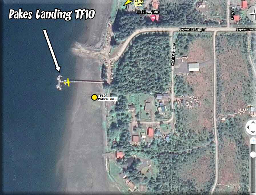
| Pakes Landing Dock | 56.67714, -132.93533 | 065° | Docks B | Water | TF10 |
| Pakes Landing (H) | 56.6763,-132.9337 | 073° | Docks B | Heli | TF10 |
| Paulson Bay Cabin | 60.692885, -148.399606 | 131° | USFS5 | Dock | PBC1 |
| Patching Lake Cabin | 55.61719, -131.48462 | 026° | USFS1 | Water | PTCH |
| Peninsula Pullout SPB | 55.38477, -131.73747 | 302° | SPB-JJ | Water | 9C0 |
| Peninsula Pullout SPB (H) | 55.38236,-131.73627 | 302° | Helipads | Heli | 9C0 |
| Petersburg Airport Helipad (H) | 56.80592,-132.93401 | 323° | Helipads | Heli | PAPG |
| Petersburg Docks SPB | 56.80997,-132.97012 | 074° | SPBJDL | Water | PAPD |
| Petersburg Docks SPB (H) | 56.80961,-132.97055 | 165° | SPBJDL | Heli | PAPD |
| Peterson Lake Cabin | 58.43659, -134.73572 | 221° | USFS6 | Water | PETN |
| Peterson Lake Cabin | 58.43647, -134.73510 | 222° | USFSa6 | Heli | PETN |
| Phocena Bay Cabin | 55.17625, -131.80571 | 190° | USFS1 | Water | PHOC |
| Picnic Strip - Chugach | 61.40459, -148.6072 | 036° | CHUG | Land | CH08 |
| Pigot Bay Cabin | 60.842306, -148.396849 | 255° | USFS5 | Water | PBC2 |
| Pine Island Lighthouse | 50.97532, -127.72936 | 030° | LITEBC | Water | PIL1 |
| Pine Island Lighthouse (H) | 50.975901, -127.72858 | 093° | LITEBC | Heli | PIL1 |
| Pinta Cove Shelter | 58.26643, -135.76501 | 189° | USFS10 | Water | PCUS |
| Pinta Cove Shelter (H) | 58.266128, -135.764786 | 226° | USFS10 | Heli | PCUS |
| Piper Island Cabin | 57.39259, -135.59542 | 111° | USFS12 | Water | PIPR |
| Piper Island Cabin (H) | 57.393344, -135.593183 | 209° | USFS12 | Heli | PIPR |
| Plenty Cutthroat Cabin | 55.82560, -131.45235 | 310° | USFS1 | Water | PLEN |
| Plotnikof Lake Cabin | 56.58804, -134.85993 | 357° | USFS12 | Water | PLOT |
| Plotnikof Lake Cabin (H) | 56.588238, -134.859975 | 353° | USFS12 | Heli | PLOT |
| Point Adkinson Lighthouse | 49.330150, -123.26349 | 253° | LITEBC | Water | PAL1 |
| Point Adkinson Lighthouse (H) | 49.330230, -123.26351 | 268° | LITEBC | Heli | PAL1 |
| Point Amagura Cabin | 55.45355, -133.35880 | 150° | USF4 | Water | PTAM |
| Point Baker SPB | 56.351955, -133.62122 | 069° | SPBJDL | Water | KPB1 |
| Point Baker SPB (H) | 56.35181,-133.62051 | 121° | SPBJDL | Heli | KPB1 |
| Point Retreat Lighthouse | 58.411200, -134.95363 | 211° | LITEAK | Water | PTRL |
| Point Retreat Lighthouse (H) | 58.41062, -134.95469 | 330° | LITEAK | Heli | PTRL |
| Point Sherman Light | 58.85632, -135.15562 | 037° | LITEAK | Water | PTSH |
| Pointer Island Lighthouse | 52.061595, -127.94805 | 314° | LITEBC | Water | PILS |
| Pointer Island Lighthouse (H) | 52.06128, -127.94865 | 134° | LITEBC | Heli | PILS |
| Polk Camp Cabin | 55.357270, -132.517940 | 194° | USFS4 | Water | POL1 |
| Polk Camp Dock | 55.355800, -132.50652 | 226° | USFS4 | Water | POL1 |
| Polk Camp Cabin (H) | 55.356568, -132.517988 | 342° | USFS4 | Heli | POL1 |
| Porlier Pass Lighthouse | 49.00908, -123.58800 | 355° | LITEBC | Water | PPRL |
| Porlier Pass Lighthouse (H) | 49.00861 -123.58701 | any | LITEBC | Helo | PPRL |
| Port Alexander | 56.24667, -134.64845 | 250° | S. A. | Water | PAAP |
| Port Alberni SPB | 49.23566, -124.81720 | 359° | SPB-JJ | Water | CAW9 |
| Port Alberni SPB (H) | 49.2312,-124.8129 | 235° | Helipads | Heli | CAW9 |
| Port Chalmers Cabin | 60.216099, -147.290673 | 268° | USFS5 | Water | PCC1 |
| Port Chalmers Cabin (H) | 60.216549, -147.293578 | 085° | USFS5 | Heli | PCC1 |
| Port Hardy SPB | 50.71646, -127.47065 | 020° | SPB-JJ | Water | CAW5 |
| Port Hardy SPB (H) | 50.71357,-127.48372 | 067° | Helipads | Heli | CAW5 |
| Port Protection SPB | 56.32197, -133.6104 | 208° | SPBJDL | Water | 19P |
| Port Protection SPB (H) | 56.32188,-133.61182 | 208° | SPBJDL | Heli | 19P |
| Portage Bay Dock | 56.99780, -133.31776 | 260° | Docks B | Water | TF11 |
| Portage Bay Dock (H) | 56.99727,-133.31795 | 163° | Docks B | Heli | TF11 |
| Portage Bay USFS Cabin | 56.95430, -133.28068 | 005° | USFS7 | Water | PBUC |
| Portage Bay USFS Cabin (H) | 56.955433, -133.281247 | 125° | USFS7 | Heli | PBUC |
| Portlock Point Lighthouse | 48.826974, -123.35097 | 344° | LITEBC | Water | PPLH |
| Portlock Point Lighthouse (H) | 48.8278 -123.35237 | 117° | LITEBC | Water | PPLH |
| Power Creek Cabin | 60.624708, -145.545277 | 052° | UFSF5 | Heli | PPC2 |
| Prince Rupert (H) | 54.29359,-130.44701 | 032 | Helipads | Heli | CYPR |
| Prospect Point Lighthouse | 49.3141340, -123.141425 | 197° | LITEBC | Water | PRLH |
| Prospect Point Lighthousg (H) | 49.31411 -123.14165 | 054° | LITEBC | Heli | PRLH |
| Pulteney Point Lighthouse | 50.630703, -127.15490 | 290° | LITEBC | Water | PULT |
| Pulteney Point LIghthouse (H) | 50.63071 -127.15489 | 010° | LITEBC | Heli | PULT |
| Punchbowl Lake Shelter | 55.52936, -130.75951 | 340° | USFS1 | Water | PNUS |
| Pybus Bay Cabin | 57.34822, -134.16205 | 280° | USFS3 | Water | PYBU |
| Back to Top of WayPoint Table | |||||
| - Q - | |||||
Location Name |
Latitude/Longitude |
Head |
Pkg |
Sur | IOAC |
| Quatsino Lighthouse | 50.44210, -128.03070 | 000° | LITEBC | Water | QUL1 |
| Quatsino Lighthouse (H) | 50.44165, -128.03142 | 292° | LITEBC | Heli | QUL1 |
| Back to Top of WayPoint Table | |||||
| - R - | |||||
Location Name |
Latitude/Longitude |
Head |
Pkg |
Sur | IOAC |
| Race Rock Light | 48.298980, -123.5315 | 178° | LITEBC | Water | RRI1 |
| Race Rock Light (H) | 48.298449, -123.53208 | 122° | LITEBC | Heli | RRI1 |
| Raven & Eagle Cabin A68 | 59.55469, -139.51121 | 226° | USFS11 | Tundra | A68 |
| Raven & Eagle Cabin (H) | 59.554477, -139.511530 | 342° | USFS11 | Heli | A68 |
| Ravens Roost Cabin | 56.76212, -132.93568 | 313° | USFS7 | Tundra | RAVN |
| Red Bay Lake Cabin | 56.25341, -133.31507 | 051° | USFS8 | Water | RBUC |
| Red Bull Airstrip-Chugach | 61.125269, -148.71422 | 059° | CHUG | Land | CH21 |
| Reflection Lake Cabin | 56.01270, -131.56963 | 333° | USFS1 | Water | RLC2 |
| River's Inlet SPB | 51.68277, -127.24786 | 087° | SPB-JJ | Water | CAU8 |
| River's Inlet SPB (H) | 51.6832, -127.2604 | 029° | Helipads | Heli | CAU8 |
| Roche Harbour SPB | 48.57093, -123.18490 | 274° | SPB-JJ | Water | W39 |
| Roche Harbor SPB (H) | 48.60897,-123.15206 | 102° | Helipads | Heli | WA09 |
| Romig Cabin | 60.569755, -149.878891 | 133° | USFS5 | Water | RCA1 |
| Romig Cabin (H) | 60.568606, -149.874756 | 294° | USFS5 | Heli | RCA1 |
| Rosario SPB | 48.61952, -122.86436 | 345° | SPB-JJ | Water | W49 |
| Rosario SPB Helipad (H) | 48.64574,-122.87135 | 268° | Helipads | Heli | W49 |
| Rowan Bay Dock | 56.66526, -134.26204 | 057° | Docks B | Water | TF12 |
| Rowan Bay Dock (H) | 56.66624,-134.2616 | 336° | Docks B | Heli | TF12 |
| Back to Top of WayPoint Table | |||||
| - S - | |||||
Location Name |
Latitude/Longitude |
Head |
Pkg |
Sur | IOAC |
| Saginaw Dock | 56.86239, -134.18690 | 296° | Dock B | Water | TF15 |
| Saginaw Dock (H) | 56.86094,-134.18811 | 256° | Dock B | Heli | TF15 |
| Saint Johns Dock | 56.43792, -132.97163 | 116° | Dock B | Water | TF14 |
| Saint Johns Dock (H) | 56.43763,-132.9731 | 256° | Dock B | Land | TF14 |
| Salmon Bay Lake Cabin | 56.26002, -133.19648 | 256° | USFS8 | Water | SLMN |
| Salmon Lake Cabin (Karta) | 55.581400, -132.66923 | 025° | USFS4 | Water | SAL2 |
| Salmon Lake Cabin (Sitka) | 56.96081, -135.14855 | 030° | USFS12 | Water | SAM2 |
| Samsing Cove Cabin | 56.98095, -135.35221 | 195° | USFS12 | Water | SMCV |
| San Juan Bay Cabin (Dock) | 59.803588, -147.896995 | 064° | USFS5 | Water | SJB1 |
| San Juan Bay Cabin (Park) | 59.803274, -147.896145 | 085° | USFS5 | Land | SJB1 |
| San Juan Bay Cabin (H) | 59.802492, -147.886022 | 196° | USFS5 | Heli | SJB1 |
| Sand Heads Lighthouse | 49.104733, -123.30630 | 289° | LITEBC | Water | SHLH |
| Sand Heads Lighthouse (H) | 49.104799, -123.30625 | 020° | LITEBC | Helo | SHLH |
| Salt Chuck Cabin | 56.86787, -133.31749 | 265° | USFS7 | Water | CHKE |
| Salt Chuck Cabin (H) | 56.868105, -133.316785 | 293° | USFS7 | Heli | CHKE |
| Sarker Lake Cabin | 55.95716, -133.20862 | 328° | USFS4 | Water | SAR1 |
| Scarlett Point Lighthouse | 50.861316, -127.61241 | 262° | LITEBC | Water | SPL1 |
| Scarlett Point Lighthouse (H) | 50.8609453, -127.61261 | 232° | LITEBC | Heli | SPL1 |
| Scotch Cap Lighthouse | 54.393566, -164.74446 | 342° | LITEAK | Water | SIL3 |
| Scotch Cap Lighthouse (H) | 54.394427, -164.74453 | 172° | LITEAK | Heli | SIL3 |
| Scow Bay Dock | 56.77587, -132.96745 | 156° | Dock B | Water | TF13 |
| Scow Bay Dock (H) | 56.77494,-132.96561 | 064° | Dock B | Heli | TF13 |
| Sea Otter Sound Lodge | 55.78885, -133.48947 | 360° | S.A. | Water | PF11 |
| Sea Otter Sound Lodge (H) | 55.78956, -133.49144 | 277° | S.A | Heli | PF11 |
| Seal Cove SPB | 54.33377,-130.28255 | 106° | Helipads` | Water | CZSW |
| Seal Cove SPB (H) | 54.32991,-130.27956 | 211° | Helipads | Heli | CZSW |
| Seal Cove SE Parking (amphib) | 54.3291,-130.27928 | 299° | Helipads | Amph | CZSW |
| Sentinel Island Lighthouse | 58.54566, -134.92488 | 024° | LITEAK | Water | SIL2 |
| Sentinel Island Lighthouse (H) | 58.54600, -134.92403 | 229° | LITEAK | Heli | SIL2 |
| Sergief Island Cabin | 56.598841, -132.41943 | 134° | USFS9 | Water | SERG |
| Sergief Island Cabin (H) | 56.598897, -132.419255 | 162° | USFS9 | Heli | SERG |
| Seven Fathom Bay Cabin | 56.79379, -135.29705 | 055° | USFS12 | Water | SFBC |
| Seven Fathom Bay Cabin (H) | 56.793444, -135.296369 | 360° | USFS12 | Heli | SFBC |
| Seward (H) | 60.13439,-149.42201 | 360° | Helipads | Heli | PAWD |
| Shakes Slough 1 Cabin | 56.71326, -132.10464 | 338° | USFS9 | Water | HSL1 |
| Shakes Slough 1 Cabin (H) | 56.713555, -132.103854 | 299° | USFS9 | Heli | HSL1 |
| Shakes Slough 2 Cabin | 56.71378, -132.10181 | 338° | USFS9 | Water | HSL2 |
| Shakes Slough 2 Cabin (H) | 56.714191, -132.100840 | 268° | USFS9 | Heli | HSL2 |
| Shelby Strip, Chugach | 61.508063, -149.075608 | 344 | CHUG | Land | CH01 |
| Shelikof Cabin | 57.13299, -135.75048 | 076° | USFS12 | Water | SHEL |
| Shelter Bay Cabin | 60.426214, -146.663277 | 213° | USFS5 | Water | SBC1 |
| Shelter Bay Cabin (H) | 60.425160, -146.664560 | 002° | USFS5 | Heli | SBC1 |
| Sheringham Point Lighthouse | 48.37618, -123.9212 | 003° | LITEBC | Water | SHPL |
| Sheringham Point Lighthouse (H) | 48.37715, -123.92010 | 353° | LITEBC | Heli | SHPL |
| Shikoh Lake East Cabin | 57.51331, -135.05278 | 377° | USFS12 | Water | KOHE |
| Shikoh Lake West Cabin | 57.50663, -135.09170 | 247° | USFS12 | Water | KOHW |
| Shipley Bay Cabin | 56.08995, -133.50571 | 309° | USFS4 | Water | SPCO |
| Shipley Bay Cabin (H) | 56.0901387, -133.506042 | 058° | USFS4 | Heli | SPCO |
| Shrode Lake Cabin | 60.656705, -148.312214 | 056° | USFS5 | Water | SLC1 |
| Shrode Lake Cabin (H) | 60.656725, -148.31029 | 261° | USFS5 | Heli | SLC1 |
| Silver King Lodge Dock | 55.54381, -131.7195 | 273° | S.A. | Water | SKL1 |
| Silver King Lodge Heli | 55.54385, -131.71965 | 278° | S.A. | Heli | SKL1 |
| Sister Strip-Chugach | 61.301505, -148.59413 | 114° | CHUG | Land | CH13 |
| Sisters Islets Lighthouse | 49.486593, -124.43581 | 344° | LITEBC | Water | SIL1 |
| Sisters Islets Lighthouse (H) | 49.486913, -124.43508 | 131° | LITEBC | Heli | SIL1 |
| Sitka Airport Helipad (H) | 57.05344,-135.36929 | 298° | Helipads | Heli | PASI |
| Situk Lake Cabin | 59.63123, -139.39881 | 106° | USFS11 | Water | A68C |
| Skagway SPB and Heli (dock) | 59.44967,-135.3293 | 300° | SPBJDL | Water | 7K2 |
| Skagway SPB and Heli (H) | 59.45056,-135.32983 | 120° | SPBJDL | Heli | 7K2 |
| Skyfall Airstrip-Chugach | 61.134791, -148.75040 | 078° | CHUG | Land | CH20 |
| Snettisham Airport | 58.13887, -133.72905 | 157° | S.A. | W/L | 7AK2 |
| Softuk Bar Cabin (Land Parking) | 60.203019, -144.646400 | 010° | USFS5 | Land | SBC1 |
| Softuk Bar Cabin (H) | 60.202860, -144.645530 | 325° | USFS5 | Heli | SBC1 |
| Sportsmans Cabin | 57.63394, -134.38916 | 275° | USFS3 | Water | SPMN |
| Spurt Cove Cabin | 57.03542, -132.87753 | 234° | USFS7 | Water | SCUV |
| Staney Creek Cabin | 55.82058, -133.15752 | 343° | USFS4 | W/Tun | STNY |
| Staney Creek Cabin (H) | 55.821638, -133.157903 | 023° | USFS4 | Heli | STNY |
| Starrigavan Creek Cabin | 57.13216, -135.36994 | 097° | USFS12 | Water | STAR |
| Steamer Bay Cabin | 56.16622, -132.69075 | 098° | USFS9 | Water | STBY |
| Suloia Lake Cabin | 57.42056, -135.71900 | 286° | USFS12 | Water | SULO |
| ST01 - Stikine Glacier Ice Station 1 | 56.981297, -131.19582 | 299° | STIK | Ice | ST01 |
| ST02 - Stikine Glacier Ice Station 2 | 56.919076, -132.03610 | 040° | STIK | Ice | ST02 |
| ST03 - Stikine Glacier Ice Station 3 | 56.977464, -132.4619 | 150° | STIK | Ice | ST03 |
| St04 - Stikine Glacier Ice Station 4 | 57.126449, -132.24399 | 255° | STIK | Ice | ST04 |
| ST05 - Stikine Glacier Ice Station 5 | 57.372260, -132.22088 | 072° | STIK | Ice | ST05 |
| ST06 - Stikine Glacier Ice Station 6 | 57.250702, -132.44056 | 258° | STIK | Ice | ST06 |
| ST07 - Stikine Glacier Ice Station 7 | 57.374119, -132.51445 | 359° | STIK | Ice | ST07 |
| ST08 - Stikine Glacier Ice Station 8 | 57.852140, -132.800847 | 122° | STIK | Ice | ST08 |
| ST09 - Stikine Glacier Ice Station 9 | 57.897773, -133.09752 | 109° | STIK | Ice | ST09 |
| ST10 - Stikine Glacier Ice Station 10 | 57.367527, -131.43838 | 316° | STIK | Ice | ST10 |
| ST11 - Stikine Glacier Ice Station 11 | 57.666019, -132.474777 | 164° | STIK | Ice | ST11 |
| Swan Lake Cabin - Petersburg | 60.61516, -149.84289 | 078° | USFS7 | Water | SWAN |
| Swan Lake Cabin (H) Petersburg | 57.029991, -132.696558 | 021° | USFS7 | Heli | SWAN |
| Swan Lake Cabin (Chugach) | 60.615157, -149.84284 | 085° | USFS5 | Water | SWA1 |
| Swan Lake Cabin (Chugach) (H) | 60.614827, -149.842647 | 055° | USFS5 | Heli | SWA1 |
| Sweetwater Lake Cabin | 55.95618, -132.92961 | 125° | USFS4 | Water | SLFS |
| Sweetwater Lake Cabin (H) | 55.9564756, -132.92904 | 175° | USFS4 | Heli | SLFS |
| Back to Top of WayPoint Table | |||||
| - T - | |||||
Location Name |
Latitude/Longitude |
Head |
Pkg |
Sur | IOAC |
| Taku Glacier Cabin | 58.38633, -134.01343 | 137° | USFS6 | Water | TAKG |
| Taku Glacier Cabin (H) | 58.387050, -134.012776 | 110° | USFS6 | Heli | TAKG |
| Taku Glacier Lodge SPB | 58.49215,-133.9422 | 098° | SPBJDL | Water | KTKL |
| Take Glacier Lodge SPB (H) | 58.4908,-133.94153 | 088° | SPBJDL | Heli | KTKL |
| Taku Harbor SPB | 58.06855,-134.01392 | 350° | SPBJDL | Water | A43 |
| Taku Harbor SPB (H) | 58.06869,-134.01407 | 360° | SPBJDL | Heli | A43 |
| Tamgas Harbor SPB (Z43) | 55.06617, -131.54376 | 144° | SPBJDL | Water | Z43 |
| Tamgas Harbor SPB (H) | 55.06569 -131.54466 | 215° | SPBJDL | Heli | Z43 |
| Tamgas Harbor Boat ramp | 55.06769, -131.55470 | 170° | SPBJDL | Water | NA |
| Tanis Mesa Cabin (and airport) | 59.24739, -138.50190 | 236° | USFS11 | Land | A69 |
| Tanis Mesa Cabin (and airport) (H) | 59.24753, -138.502233 | 215° | USFS11 | Heli | A69 |
| Tarn Airstrip-Chugach | 61.110416, -148.75538 | 344° | CHUG | Land | CH22 |
| Tatitlek Harbour (H) | 60.8725,-146.68915 | 344° | Helipads | Heli | PAKA |
| Thomas Bay Dock | 56.96954, -132.81898 | 122° | Docks B | Water | TF18 |
| Thomas Bay Dock (H) | 56.96767, -132.82063 | 234° | Docks B | Heli | TF18 |
| Thorne Bay SPB | 55.68396, -132.52496 | 122° | SPB-F | Water | KTB |
| Thorne Bay SPB (H) | 56.96744,-132.81958 | 330° | SPB-F | Heli | KTB |
| Tiedeman Slough Cabin | 60.420913, -145.473523 | 087° | USFS5 | Water | TSC1 |
| Tiedeman Slough Cabin (H) | 60.419705, -145.471941 | 353° | USFS5 | Heli | TSC1 |
| Tonka Mountain Dock | 56.71264, -132.95322 | 334° | Docks B | Water | TF17 |
| Tonka Mountain Dock (H) | 56.71226,-132.95451 | 268° | Docks B | Heli | TF17 |
| Tokeen SPB | 55.93559, -133.32022 | 105° | SPBJDL | Water | 57A |
| Tokeen SPB (H) | 55.93877, -133.3259 | 029° | SPBJDL | Heli | 57A |
| Towers Arm Cabin | 56.83772, -133.36838 | 236° | USFS7 | W/T | TOWA |
| Tower Arm Cabin (H) | 56.83697, -133.370131 | 322° | USFS7 | Heli | TOWA |
| Tree Point Lighthouse | 54.803097, -130.93532 | 074° | LITEAK | Water | TPLH |
| Tree Point Lighthouse (H) | 54.80317,-130.93614 |
258° | LITEAK | Heli | TPLH |
| Trial Islands Lighthouse | 48.396116, -123.30382 | 122° | LITEBC | Water | TIL1 |
| Trial Islands Lighthouse (H) | 48.395774, -123.30492 | 148° | LITEBC | Heli | TIL1 |
| Triangle Island Lighthouse | 50.866066, -129.07597 | 128° | LITEBC | Water | TIS1 |
| Triangle Island Lighthouse (H) | 50.862443, -129.08211 | 182° | LITEBC | Heli | TIS1 |
| Triple Islands Lighthouse | 54.294991, -130.87995 | 094° | LITEBC | water | TILS |
| Triple Islands Lighthouse (H) | 54.29475, -130.88005 | 283° | LITEBC | Heli | TILS |
| Troller's Cove Cabin | 55.36478, -132.19836 | 055° | USFS4 | Water | TROL |
| Troublesome Creek Strip-Chugach | 61.272844, -148.61459 | 231° | CHUG | Land | CH15 |
| Trout Lake Cabin | 0.553457, -149.899806 | 011° | USFS5 | Water | TLC1 |
| Trout Lake Cabin (H) | 60.555041, -149.898237 | 170° | USFS5 | Heli | TLC1 |
| Twelvemile Cabin | 55.36723, -132.72587 | 154° | USFS8 | Water | KTEV |
| Twelvemile Cabin (H( | 55.366738, -132.724029 | 249° | USFS8 | Heli | KTEV |
| Twin Lakes Cabin | 56.69845, -132.2689 | 133° | USFS9 | Water | TWNL |
| Back to Top of WayPoint Table | |||||
| - U - | |||||
Location Name |
Latitude/Longitude |
Head |
Pkg |
Sur | IOAC |
| Upper Paradise Lake Cabin | 60.368377, -149.012024 | 211° | USFS5 | Water | UPL1 |
| Upper Paradise Lake Cabin (H) | 60.367913, -149.015113 | 072° | USFS5 | Heli | UPL1 |
| Upper Russian Lake Cabin | 60.356524, -149.892701 | 358° | USFS5 | Water | URL1 |
| Back to Top of WayPoint Table | |||||
| - V - | |||||
Location Name |
Latitude/Longitude |
Head |
Pkg |
Sur | IOAC |
| View Cove Dock | 55.08397 -133.02010 | 164° | Docks B | Water | TF18 |
| View Cove Dock (H) | 55.08389 -133.02017 | 165° | Docks B | Heli | TF18 |
| Virginia Lake Cabin | 56.48261, -132.14577 | 032° | USFS9 | Water | VRNA |
| Back to Top of WayPoint Table | |||||
| - W - | |||||
Location Name |
Latitude/Longitude |
Head |
Pkg |
Sur | IOAC |
| Ward Cove SPB Dock | 55.40536,-131.72023 | 039° | SPBJDL | Water | WCS1 |
| Ward Cove Cruise Ship Dock | 55.40709,-131.72534 | 210° | SPBJDL | Water | WSC1 |
| Ward Cove Helicopters Pad H-1(H) | 55.40616,-131.71841 | 050° | SPBJDL | Heli | WCS1 |
| Ward Cove Shipping Helipad H-2 (H) | 55.40504,-131.71999 | 120° | SPDJDL | Heli | WCS1 |
| Ward Cove Cruise Helipad H-3 (H) | 55.40684,-131.72775 | 300° | SPDJDL | Heli | WCw1 |
| Warfare Center USN | 55.54115,-131.76547 | 382° | WC | Land | USN1 |
| Warfare Center USN (H) | 55.54202,-131.75969 | 066° | WC | Heli | USN1 |
| Wasillabilly - Chugach | 61.5093873, -148.99378 | 331° | CHAG | Land | CH03 |
| Waterfall SPB | 55.29614 -133.24442 | 204° | SPBJDL | Wster | KWF |
| Waterfall SPB (H) | 55.29419 -133.24388 | 091° | SPBJDL | Heli | KWF |
| West Point Cabin | 57.00727, -133.3334 | 326° | USFS7 | Water | WPUC |
| West Point Cabin (H) | 57.007541, -133.334175 | 020° | USFS7 | Heli | WPUC |
| West Swan Lake Cabin | 60.632483, -149.88496 | 320 | USFS5 | Water | SWA2 |
| West Turner Lake Cabin | 58.31093, -133.9556 | 284° | USFS6 | Water | WTLC |
| White Sulphur Springs Cabin | 57.804760, -136.33706 | 334° | USFS12 | Water | WWSC |
| White Sulphur Springs Cabin (H) | 57.806376, -136.338525 | 060° | USFS12 | Heli | WWSC |
| Wilson Narrows Cabin | 55.47911, -130.5818 | 122° | USFS1 | Water | WLSN |
| Wilson View Cabin | 55.54228, -130.5249 | 070° | USFS1 | Water | WLVW |
| Wilson View Cabin (H) | 55.543219, -130.52451 | 142° | USFS1 | Heli | WLVW |
| Windfall Lake Cabin | 58.50827, -134.7243 | 253° | USFS6 | Water | WFUC |
| Winstanley Island Cabin | 55.45500, -130.9058 | 355° | USFS1 | Water | WSIC |
| Winstanley Island Cabin (H) | 55.453891 -130.904046 | 236° | USFS1 | Heli | WSIC |
| Winstanley Lake Cabin | 55.42844, -130.8179 | 332° | USFS1 | Water | WSLC |
| Wolf Point Airstrip - Chugach | 61.4567554, -148.676274 | 221° | CHUG | Land | CH04 |
| Wrangell Helipad (H) | 56.48506,-132.38037 | 195° | Helipads | Heli | PAWG |
| Back to Top of WayPoint Table | |||||
| - X - | |||||
Location Name |
Latitude/Longitude |
Head |
Pkg |
Sur | IOAC |
| Back to Top of WayPoint Table | |||||
| - Y - | |||||
Location Name |
Latitude/Longitude |
Head |
Pkg |
Sur | IOAC |
| Yakutat SPB | 59.56285, -139.74149 | 328° | SPBJDL | Water | 2Y3 |
| Yakutat SPB (H) | 59.56264,-139.74083 | 162° | SPBJDL | Heli | 2Y3 |
| Yankee Cove Heliport (H) | 58.39112,-134.76573 | 342° | MissHel | Heli | 73AK |
| Yes Bay (H) | 55.9159946,-131.79797 | 020° | YesBay | Heli | 78K |
| Yes Bay Lodge Dock | 55.915257 ,-131.79806 | 012° | YesBay | Water | 78K |
| Young Lake North Cabin | 58.13410, -134.49451 | 340° | USFS3 | Water | YNGN |
| Young Lake South Cabin | 58.11679, -134.46835 | 140° | USFS3 | Water | YNGS |
| Young Lake South Cabin (H) | 58.116792, -134.4678 | 166° | USFS3 | Heli | YNGS |
| Back to Top of WayPoint Table | |||||
| - Z - | |||||
Location Name |
Latitude/Longitude |
Head |
Pkg |
Sur | IOAC |
| Zeballos SPB | 49.9801, -126.8460 | 193° | SBP-JJ | Water | CAA5 |
| Zebalos SPB (H) | 49.97878,-126.84491 | 193° | Helipads | Heli | CAA5 |
| Back to Top of WayPoint Table | |||||
| Misty Flying Club | |
Click on Image Below to go to the MFC Operations Web Page

Frequently Asked Questions and Facts
What is the Misty Flying Club?
Why is it called "Misty Flying Club" rather than Misty's Flying Club?
What is the Target Geographical Area?
Software Required for the "Misty Flying Club"
|
|
| Click on Image Below to go to the MFC Operations Web Page
| |
| Back to Top |
| FS Starter (PAYWARE) Program | ||
HELICOPTER NOTAM!!! There is a way to start the helicopters ON THE GROUND and you also are able to load a "land-based" (non-water) helicopter to any Sea Plane Base helipad in RTMM. The program costs $10 US and will start not only helicopters, but all aircraft exactly where you need to start. RTMM has created a databas (POI.txt) that you can add to your FS Starter and you get all 600+ waypoint starting points with all 98 helipads included. The Internet Link below takes you to the sales point to purchase this program. Please look at the RTMM readme first because there are some special things you should know and understand.
|
||
| Back to Top | ||