

| Flight Plans for RTMM and MFC | ||
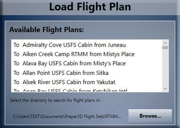
Click on the "zip" button below to download the RTMM-MFC Flight Plans folder. Copy the flight plans in the folder and paste them into your sim's "flight plan documents area" NOTAM: If you do not want to mix these in with your own flight plans, make a separate folder for them and place them in the flight plan documents area. This is explained in the "readme" in the RTMM-MFC Flight Plans folder.
(UPDATED: 07.02.2019)
* MFC = Misty Flying Club. Each plan is being given a flight number. These are used with SIM-ACARS when you are flying an MFC-Credit Route. We are starting at the top of the list and working down. This does not affect the flight plan, these are simply being given a flight number as they are entered into the MFC database. |
||
 Total RTMM-MFC Flight Plans Set - Every scenery location we offer at RTMM has a flight plan, usually from a [relatively] nearby airport or seaplane base. These plans can be entered into your aircraft's gps and will give you a route to fly (many with autopilot) directly to the RTMM scenery location.
| Misty Flying Club | |
Click on Image Below to go to the MFC Operations Web Page

Frequently Asked Questions and Facts Misty Flying Club (VA)
What is the Misty Flying Club?
Why is it called "Misty Flying Club" rather than Misty's Flying Club?
What is the Target Geographical Area?
How will these work, software needed?
|
|
| Click on Image Below to go to the MFC Operations Web Page
| |
| Back to Top |
| RTMM GOOGLE EARTH KMZ by "Rustam" (Vüqar Quliyev) | |
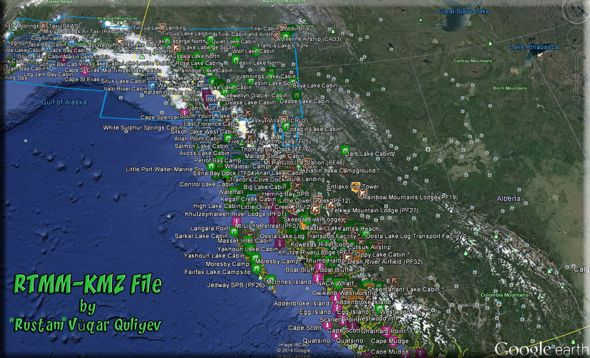
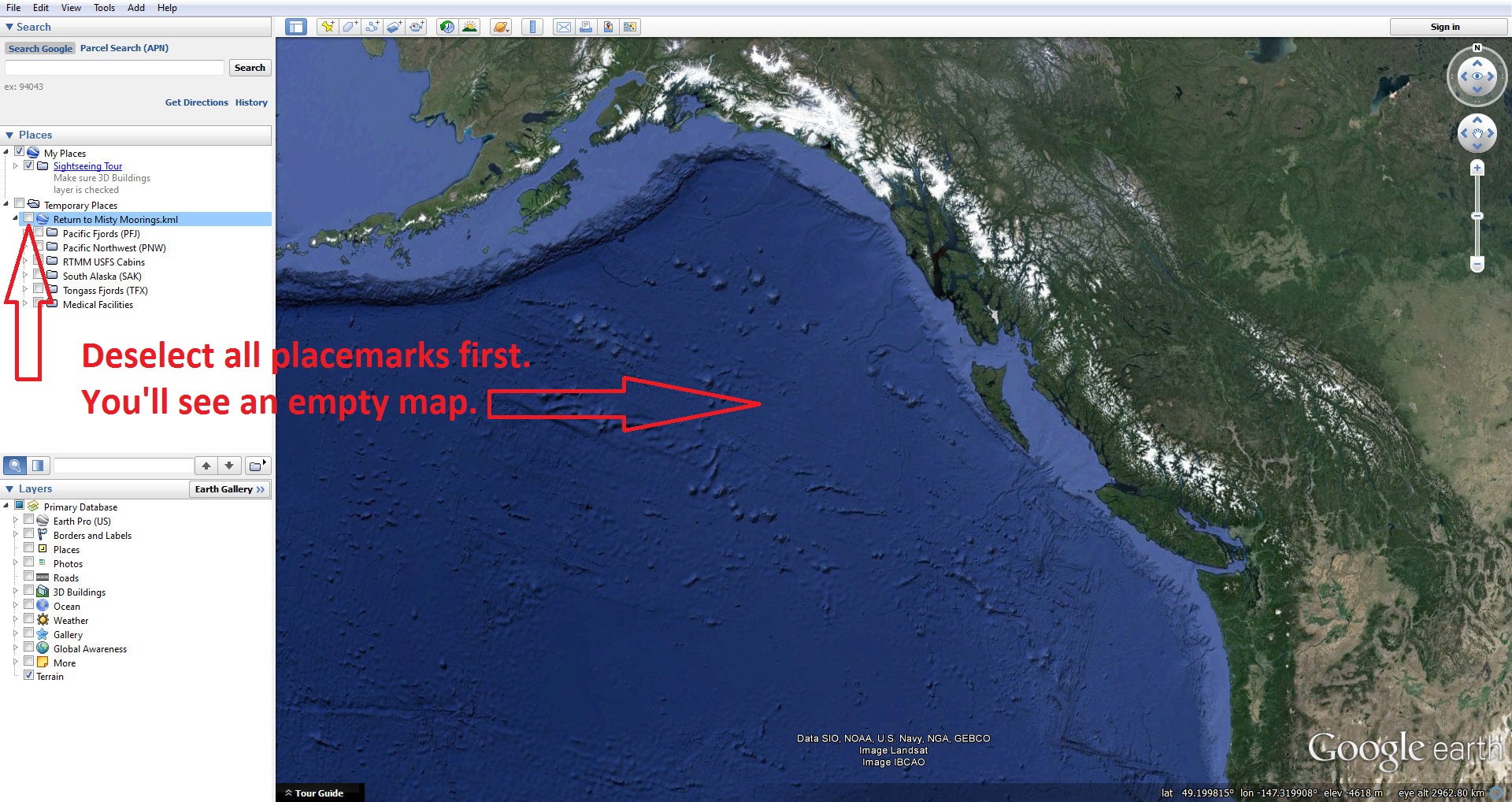
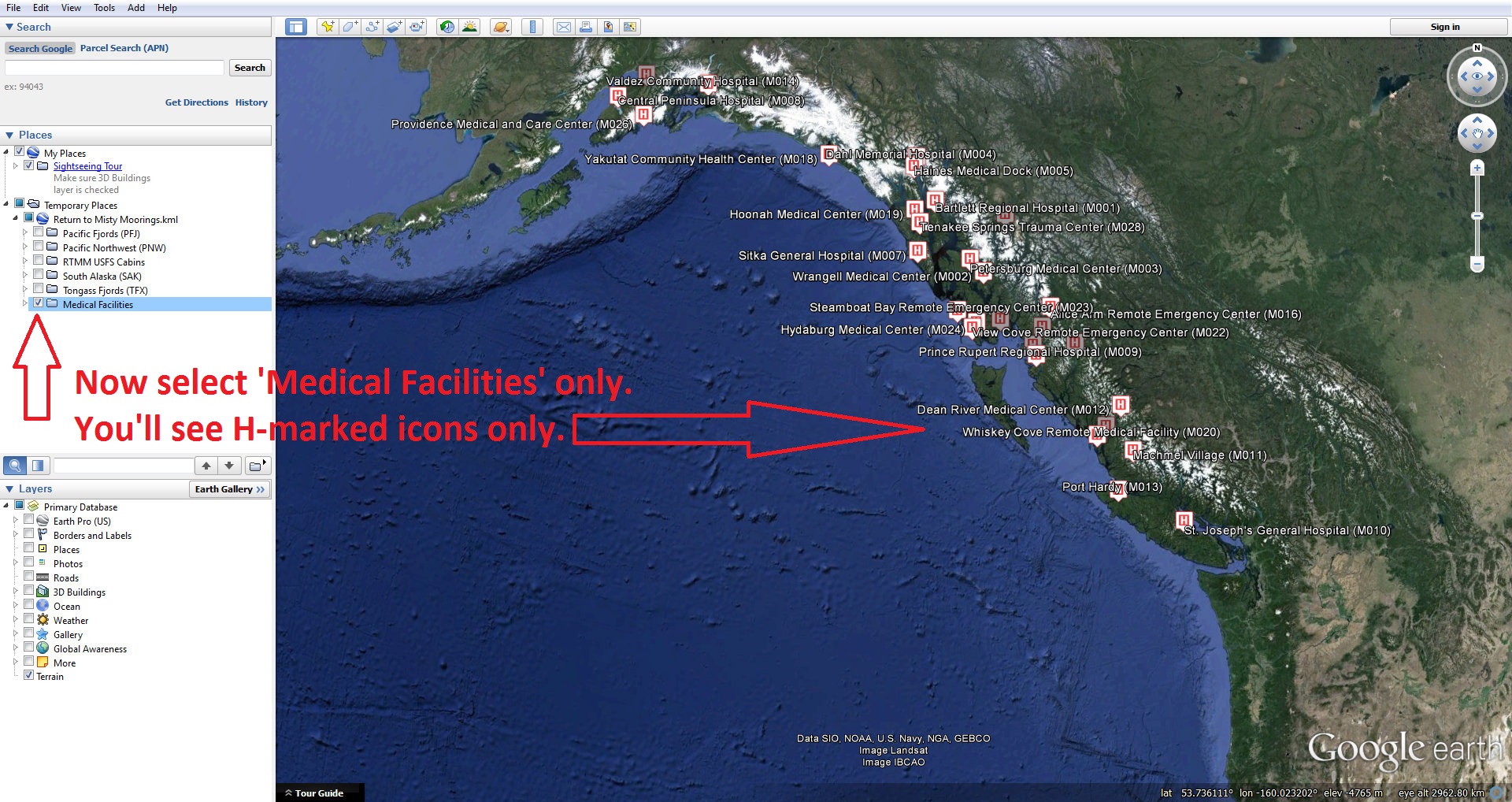
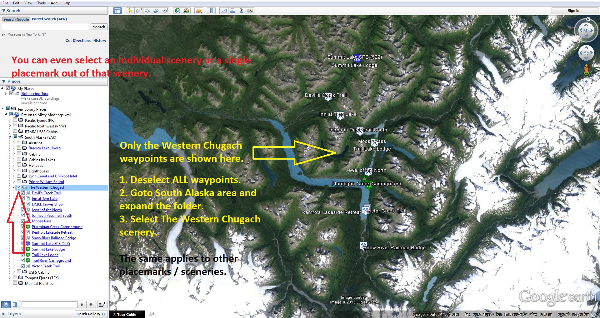
RTMM KMZ by "Rustam" (Vüqar Quliyev) This is a Google Maps KMZ file covering the whole RTMM area. It's compiled respecting the naming convention for RTMM sceneries released as of Nov. 2014 but also includes locations of the USFS cabins and historical lighthouses shipped with ORBX/FSAddon/RTMM packages. The KMZ file consists of 605 individual place marks in total. All individual locations and some of the scenery folders will provide you with some basic info about the area/scenery but apart from these descriptions, most of these "clickable" spots contain buttons which will take you to relevant flight maps, trip tickets and/or external information resources such as Wikipedia or Lighthouse Explorer, where possible. Click on the picture above to see a larger image. But even the larger image will not do the details of this justice. There is an amazing amount of data contained in this file. The "readme" is in the zip along with the "KMZ" file.
Here is "how to" select the labels you want to see in this amazing file (Click on Pic below to Enlarge):
|
|
| Back to Top | |
| Dieter's Corner | |
 DIETER's CORNER: Here we proudly publish Dieter Linde's Plan-G cvs (data) files that will add to your enjoyment for RTMM. These are the "way point" files for Plan-G. Also, be sure to check the NOTAM and the INSTRUCTIONS that are in the RTMM FAQ (FAQ Page/"P" Tab/ Plan-G Instructions). Dieter has also published additional files you may have interest in downloading for other scenery areas you may have. We have also included those below.
Plan-G Data Files for RTMM Areas DIETER's CORNER: Here we proudly publish Dieter Linde's Plan-G cvs (data) files that will add to your enjoyment for RTMM. These are the "way point" files for Plan-G. Also, be sure to check the NOTAM and the INSTRUCTIONS that are in the RTMM FAQ (FAQ Page/"P" Tab/ Plan-G Instructions). Dieter has also published additional files you may have interest in downloading for other scenery areas you may have. We have also included those below.
Plan-G Data Files for RTMM Areas
NOTAM: For More Information on for how these way points are used, see the Here2There Page Table |
|
PLAN-G Data Files used by additional (NOT-RTMM) software programs - by Dieter Linde |
|
Additional Plan-G Data Files for NON RTMM Areas
New Zealand North
New Zealand South
BC PNW Lighthouses/Mike Mann Scenery
Kwinamass_Khutzemateen - (Published by Dieter Linde with Permission of Douglas Keech)*
|
|
| Back to Top | |

| GPS - Adding Waypoints | ||
|
||
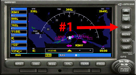
Step #1 Use the "Direct" button on the right side of the GPS. |
 |
|
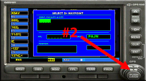
Step 2 Click on the little arrows on the curser knob ... just on one of those two SMALLER arrows. When you do, you will get what you see to the right. Now you type in the way point (R) number. (Never Use CAPS when entering information into the GPS). |
 |
|
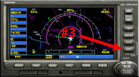
Step 3 Once the way point is typed in correctly, you then click on the "ENT" (enter) button. The GPS will ask you if you want to "Activate?" You click the "ENT" button again to activate the new direct route. The GPS will then display your direct route to the waypoint as seen in the image to the right. |
 |
|
NOTAMs: Repositioning Tip: Often, you will have to deviate from the original GPS track. When you want a quick NEW track directly to the GPS target. Click on the "D" on the GPS and then click on ENT twice. That gives you a new direct course to your waypoint without having to enter anything.
|
||
| Back to Top | ||
| Using A Starting Point with Latitude and Longitude (How to) | ||
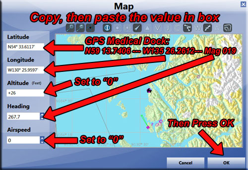
| How to use Starting Points and Starting Position: Often, there will not be an "airport" to start from and the program will ask you to "position your aircraft using the starting points". All starting points for all medical facilities are listed in the above facilities tables. You will find LATITUDE, LONGITUDE and MAG (magnetic heading). To position yourself directly at the starting point:
Open the MAP feature of your Simulator (If you don't use "Magnetos" reprogram your keyboard for "M" opening up the simulator's MAP).
6. Press OK ... your aircraft will be positioned exactly at the starting point.
|
||
| Start at Airport or Dock | ||
Often a starting position will be an airport runway, helipad or dock. Here is how you position the aircraft for this situation: |
||
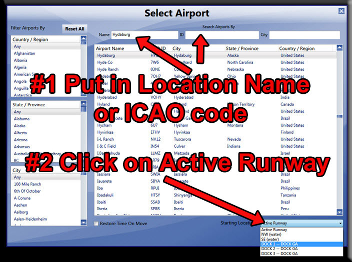
1. Use your simulator's "GO TO AIRPORT" function. Put the name of the location or the ICAO code into one of the two boxes.
2. Click on the "Active Runways" box and you will get a "drop down" for that airport allowing you to start in any place you choose there.
3. Press OK, you will find yourself positioned in the correct place. |
 |
|
| Back to Top | ||
| Way Points Table | |||||||
| Way Points Table (Starting Points for All RTMM Locations) | |||||||
 |
Clicking on the zip button below downloads the latest RTMM Waypoints.zip file for you. You install it as you install a scenery location and activate it you sim's library. When you add a way point to the gps, the position will show for you . |
||||||
Facility Name |
Name of location as it is listed on the Scenery Page, Click on name for map to location |
||||||
| Lat/Long | GPS Coordinates | ||||||
| Mag | Direction to set your vehicle for proper startup heading | ||||||
| SPB | Indicates a Sea Plane Base Start Point (No Map Available) | ||||||
| Pkg | Necessary software PFJ, PNW , TF, SAK, NRM or GV (Global Vector) | ||||||
| Type | Type of landing zone, water, ice, land, etc. | ||||||
| Tic (click to view) | Indicates a trip ticket, D Dispatch available, FT Float Trip Available | ||||||
| Starting Points | How to set starting points | ||||||
| Back to Top | |||||||
| Click on a Letter to Navigate Alphabetically or Scroll Down to Browse | |
| A B C D E F G H I J K L M N O P Q R S T U V W X Y Z legend | |
| Back to Top | |
| - A - | |||||||
Facility Name |
Latitude |
Longitude |
Mag |
Type |
Pkg |
Tic | Way Point |
| Adams Inlet Cabin | N58 53.0902 |
W135 48.8853 |
168 |
W |
SAK |
R053A |
|
| Admiralty Cove USFS | N58 10.56 |
W134 33.75 |
024 |
W |
SAK |
R366A |
|
| Aiken Creek Camp | N55 7.18 |
W132 12.19 |
004 |
W |
PFJ |
R001A |
|
| Aishihik Lk North Cabin | N61 35.6540 |
W137 28.4471 |
248 |
W |
SAK |
R054A |
|
| Aishihik Lk South Ruins | N61 11.7938 |
W137 0.0241 |
359 |
W |
SAK |
R055A |
|
| Alava Bay Cabin USFS | N55 13.54 |
W131 9.21 |
254 |
W |
PFJ |
R367A |
|
| Allan Point Cabin USFS | N57 14.51 |
W135 23.85 |
312 |
W |
SAJ |
R368A |
|
| Alpine Inn | N60 29.5135 |
W149 49.2009 |
052 |
W |
SAK |
R614A |
|
| Allakaket Lodge | N66 33.7736 |
W152 39.4076 |
173 |
L |
VEC |
R002A |
|
| Alsek River Cabin USFS | N59 11.24 |
W138 25.78 |
284 |
W |
SAK |
R369A |
|
| Anan Bay Cabin USFS | N56 11.20 |
W131 53.44 |
024 |
W |
PFJ |
R370A |
|
| Anan Lake Cabin USFS | N56 7.50 |
W131 53.15 |
112 |
W |
PFJ |
R371A |
|
| Anchor Pass Cabin USFS | N55 58.33 |
W131 23.96 |
031 |
W |
PFJ |
R372A |
|
| Anchorage Point Cabin | N59 10.5529 |
W135 28.4944 |
109 |
L |
SAK |
R615A |
|
| Anderson Lake Cabin | N61 40.88 |
W128 49.90 |
036 |
W |
SAK |
R023A |
|
| Andrew Bay Dock | N53 51.3833 |
W126 19.2060 |
209 |
W |
PFJ |
R056A |
|
| Annex Creek Hydro | N58 19.5980 |
W134 7.5200 |
244 |
W |
SAK |
PP13 |
|
| Appleton Cove Cabin USFS | N57 28.3808 |
W135 15.5576 |
38 |
W |
SAK |
R373A |
|
| Arctic Angel BWEP (9AK4) | N64 8.2048 |
W145 49.7980 |
047 |
W |
SAK |
# |
9AK4 |
| Armin F. Koernig (AFK) Hatchery | N60 3.0481 |
W148 3.9049 |
318 |
W |
SAK |
R057A |
|
| Ashlulm Creek Fishing Lodge | N51 45.2630 |
W126 55.0876 |
138 |
W |
PFJ |
R058A |
|
| Avoss Lake Cabin USFS | N56 42.2912 |
W134 55.6444 |
139 |
W |
TFX |
R374A |
|
| Back to Top of Location Table | |||||||
| - B - | |||||||
Facility Name |
Latitude |
Longitude |
Mag |
Type |
Pkg |
Tic | Way Point |
| Badger Lake Cabins | N55 12.8658 |
W130 48.1373 |
049 |
W |
PFJ |
R003A |
|
| Baird LeConte Glacier Tour | N57 15.16 |
W132 12.72 |
038 |
L |
TFX |
NA |
|
| Bakewell Lake Cabin USFS | N55 15.6538 |
W130 40.2689 |
100 |
W |
R375A |
||
| Baranof Lake Cabin USFS | N57 5.12 |
W134 51.66 |
220 |
W |
SAK |
R376A |
|
| Barber Cabin USFS | N60 26.2516 |
W149 59.2433 |
129 |
W |
SAK |
R110A |
|
| Barnes Lake Cabin USFS | N56 0.6825 |
W132 58.5072 |
153 |
W |
TFX |
R377A |
|
| Bartlett Cove SPB | N58 27.24 |
W135 53.44 |
221 |
W |
SAK |
BQV |
|
| Beach River Cabin USFS | N60 1.06 |
W147 22.50 |
302 |
W |
SAK |
R244A |
|
| Bear Camp Research (CZBC) | N49 32.8325 |
W122 29.2505 |
208 |
L |
PNW |
CZBC |
|
| Bear Observatory | N56 10.9420 |
W131 53.4225 |
329 |
L/W |
PFJ |
R005A |
|
| Bear Observatory Cabin USFS | N56 9.4624 |
W131 53.3467 |
104 |
W |
PFJ |
R378A |
|
| Bear River Lodge | N56 5.43 |
W129 53.27 |
059 |
W |
PFJ |
R020A |
|
| Bear Lakes Cabin | N61 16.3663 |
W137 34.2017 |
338 |
W |
SAK |
R059A |
|
| Beaver Camp Cabin USFS | N55 32.07 |
W131 4.87 |
284 |
W |
PFJ |
R379A |
|
| Beecher Pass Cabin USFS | N56 35.05 |
W133 03.05 |
281 |
W |
PFJ |
R380A |
|
| Bennett Lake Facility | N59 50.7343 |
W134 59.7195 |
193 |
W |
SAK |
R060A |
|
| Berg Bay Cabin USFS | N56 21.75 |
W132 0.43 |
020 |
W |
PFJ |
R381A |
|
| Berner's Bay Cabin USFS | N58 46.1085 |
W134 56.0628 |
152 |
W |
SAK |
R572A |
|
| Bettles Lodge | N66 55.0935 |
W151 31.0584 |
127 |
L |
SAK |
R006A |
|
| Big Bay Cabin USFS | N60 9.12 |
W150 51.11 |
102 |
W |
SAK |
R382A |
|
| Big Bend Lake Cabin | N61 12.3327 |
W142 15.4346 |
226 |
W |
SAK |
R573A |
|
| Big Creek Lodge (W) | N51 9.1362 |
W123 33.5555 |
346 |
W |
NRM |
PF61 |
|
| Big Creek Lodge (L) | N51 8.9570 |
W123 33.5897 |
208 |
L |
NRM |
PF61 |
|
| Big Falls Hydro Power Plant | N53 59.08 |
W129 43.48 |
137 |
W |
PFJ |
R008A |
|
| Big Falls Cove Cabin | N53 58.9988 |
W129 44.3902 |
079 |
W |
PFJ |
R365A |
|
| Big Goat Lake Cabin USFS | N55 32.05 |
W130 36.23 |
174 |
W |
PFJ |
R383A |
|
| Big Indian Creek Cabin USFS | N60 52.80 |
W149 56.97 |
250 |
L |
SAK |
R384A |
|
| Big John Bay Cabin USFS | N56 50.75 |
W133 41.44 |
055 |
W |
PFJ |
R385A |
|
| Big Lake Cabin | N55 25.62 |
W131 11.01 |
004 |
W |
PFJ |
R009A |
|
| Big Shaheen Cabin USFS | N57 42.0728 |
W134 16.2329 |
251 |
W |
TFX |
R296A |
|
| Binkley Slough Cabin USFS | N56 36.62 |
W132 26.02 |
284 |
W |
PFJ |
R386A |
|
| Biorka Island Dock TF03 | N56 51.24 |
W135 31.24 |
103 |
W |
TFX |
TF03 |
|
| Black Bear Lake Cabin USFS | N55 32.4449 |
W132 51.4460 |
176 |
W |
TFX |
R387A |
|
| Black Rapids Airport BWEP (5BK) | N63 31.9164 |
W145 51.6105 |
215 |
L |
B/V |
X |
5BK |
| Black Rapids, The Lodge at | N63 33.1280 |
W145 51.8589 |
053 |
L |
B/V |
R010A |
|
| Blind Pass Cabin USFS | N55 53.64 |
W131 39.04 |
126 |
W |
PFJ |
R388A |
|
| Blue Lake Hydro (APP) | N57 3.8380 |
W135 12.0060 |
181 |
W |
PFJ |
PP16 |
|
| Blue Cat lake Cabin | N55 30.5191 |
W133 40.0474 |
44.3 |
W |
TFX |
R011A |
|
| Boat Bluff Lighthouse | N52 38.5551 |
W128 31.4197 |
303 |
W |
PFJ |
R595A |
|
| Bob's Bay Cabin | N55 12.6226 |
W133 9.7150 |
250 |
W |
TFX |
R012A |
|
| Bohemia Basin Shelter USFS | N57 59.1957 |
W136 22.6802 |
334 |
W |
TFX |
R575A |
|
| Bonilla Island Light | N53 29.61 |
W130 38.15 |
186 |
W |
PFJ |
R645A |
|
| Border Lake Provincial Park | N56 20.34 |
W130 44.71 |
186 |
L |
PFJ |
R013A |
|
| Boswell Bay Airstrip Dock | N60 25.4398 |
W146 7.6639 |
114 |
W |
SAK |
AK97 |
|
| Bowser Lake Cabin | N56 25.31 |
W129 43.29 |
303 |
W |
PFJ |
R292A |
|
| Boya Lk Provincial Park Cabins | N59 22.06 |
W129 6.24 |
301 |
W |
SAK |
R014A |
|
| Brad's Bait&BBQ Ashlulm Crk | N51 41.30 |
W126 53.95 |
239 |
W |
PNW |
R102A |
|
| Brad's Bait&BBQ Big Fall Cove | N53 59.01 |
W129 44.25 |
082 |
W |
PFJ |
R293A |
|
| Brad's Bait&BBQ Cornwall Pt | N53 41.6956 |
W125 55.6907 |
110 |
W |
PFJ |
R294A |
|
| Brad s Bait&BBQ Hang Em High | N55 11.8650 |
W132 15.1702 |
127 |
W |
PFJ |
R295A |
|
| Brad's Bait&BBQ Hollis | N55 34.1041 |
W132 34.0012 |
164 |
W |
PFJ/TF |
R577A |
|
| Brad's Bait&BBQ Dean River | N52 49.8735 |
W126 57.8309 |
091 |
W |
PFJ |
R297A |
|
| Brad's Bait&BBQ Owikeno N. | N51 50.6195 |
W126 39.9167 |
229 |
W |
PNW |
R100A |
|
| Brad's Bait&BBQ Owikeno W | N51 40.9853 |
W127 10.4584 |
204 |
W |
PNW |
R101A |
|
| Brad's Bait&BBQ Skeena River | N54 19.22 |
W129 13.17 |
156 |
W |
PFJ |
R016A |
|
| Brad's Bait&BBQ Stewart BC W | N55 55.0926 |
W129 59.7053 |
350 |
W |
PFJ |
R017A |
|
| Brad's Bait&BBQ Stewart BC H | N55 55.0892 |
W129 59.6468 |
Any |
H |
PFJ |
R017A |
|
| Brad's Bait&BBQ Spud's Creek | N55 29.7272 |
W130 6.4422 |
179 |
W |
PFJ |
R298A |
|
| Brad's Bait&BBQ Terrace BC | N54 28.4113 |
W128 34.8112 |
279 |
W |
PFJ |
R299A |
|
| Brad's Bait&BBQ Victory Valley | N53 6.6756 |
W127 9.8479 |
219 |
W |
PFJ |
R300A |
|
| Brad's Bait&BBQ Wilson River | N55 27.7411 |
W130 36.7322 |
323 |
W |
PFJ |
R301A |
|
| Bradley Lake Hydro Outfall (H) | N59 46.7919 |
W150 55.9091 |
099 |
H |
SAK |
R015A |
|
| Bradley Lake Hydro Dam(W) | N59 45.29 |
W150 51.25 |
278 |
W |
SAK |
R015A |
|
| Breiland Slough Cabin USFS | N56 38.31 |
W133 09.62 |
168 |
W |
PFJ |
R389A |
|
| Brent's Beach Cabin USFS | N57 8.29 |
W135 33.85 |
197 |
W |
SAK |
R390A |
|
| Brenwicks Airport 3Z5 | N62 3.6297 |
W145 25.6048 |
100 |
L |
SAK |
3Z5 |
|
| Bromley Peak Ice Station | N55 53 54.80 |
W129 40 28.80 |
206 |
L |
PFJ |
PP43 |
|
| Bronson's Creek | N56 40.59 |
W131 5.63 |
132 |
L |
TFX |
R018A |
|
| Burnet Inlet Cabin | N56 9.76 |
W132 27.99 |
104 |
W |
PFJ |
R019A |
|
| BWEP Executive Field (PF58) | N64 51.9952 |
W147 40.9546 |
050 |
L |
SAK |
PF58 |
|
| Back to Top of Location Table | |||||||
| - C - | |||||||
Facility Name |
Latitude |
Longitude |
Mag |
Type |
Pkg |
Tic | Way Point |
| Cambria Ice Station | N55 52.0600 |
W129 29.9200 |
131 |
L |
PFJ |
PF42 |
|
| Campbell's Knife Shop (TWC) | N60 21.6341 |
W149 20.9532 |
331 |
L |
SAK |
R616A |
|
| Canoona Fish Camp W | N53 1.75 |
W128 38.52 |
310 |
W |
PFJ |
R087A |
|
| Canoona Fish Camp (Land) | N53 1.78 |
W128 38.65 |
234 |
L |
PFJ |
R087A |
|
| Canyon Cabin W | N51 35.83 |
W126 26.59 |
135 |
W |
PNW |
R061A |
|
| Canyon Cabin H | N51 35.81 |
W126 26.55 |
109 |
H |
PNW |
R061A |
|
| Canyon Lake Campground | N61 4.8662 |
W137 0.4368 |
313 |
W |
SAK |
R302A |
|
| Cape Decision Lighthouse | N56 0.11 |
W134 8.19 |
140 |
W |
TFX |
TF01 |
|
| Cape Scott Windfarm | N50 42.7964 |
W127 54.6453 |
NA |
NA |
PNW |
R247A |
|
| Cape Spencer Lighthouse | N58 11.93 |
W136 38.27 |
236 |
W |
PFJ |
R088A |
|
| Caribou Creek Cabin | N60 47.04 |
W149 40.53 |
095 |
W |
SAK |
R329A |
|
| Caribou Island Cabin USFS | N60 14.23 |
W151 03.77 |
348 |
L |
SAK |
R394A |
|
| Carol Glacier Cabin | N58 57.5200 |
W136 34.0077 |
135 |
W |
SAK |
R303A |
|
| Carol Glacier Campsite | N58 59.3584 |
W136 25.4020 |
135 |
W |
SAK |
R304A |
|
| Cascade Creek Cabin USFS | N56 59.7837 |
W132 47.1011 |
240 |
W |
PFJ |
R391A |
|
| Cascade Creek Hydro | N57 1.7519 |
W132 44.4136 |
291 |
W |
PFJ |
PP11 |
|
| Castle Flats Cabin USFS | N56 38.79 |
W133 15.02 |
215 |
W |
PFJ |
R392A |
|
| Castle River Cabin USFS | N56 38.56 |
W133 15.50 |
289 |
W |
PFJ |
R393A |
|
| Cedar Ridge Lake Retreat | N55 49.2393 |
W131 23.1499 |
247 |
W |
PFJ |
R089A |
|
| Chalet de Venema | N48 44.5250 |
W121 33.2173 |
218 |
W |
PNW |
R194A |
|
| Chamiss Bay Logging | N50 4.3591 |
W127 17.0739 |
284 |
W |
PNW |
R249A |
|
| Chandalar Shelf BWEP 5CD | N68 4.0806 |
W149 34.1101 |
272 |
L |
SAK |
5CD |
|
| Chandalar Lake PALR | N67 30.1480 |
W148 29.5273 |
40.4 |
L/W |
B/V |
PALR |
|
| Charlotte Lake Lodge L | N52 9.2378 |
W125 16.7718 |
142 |
L |
PFJ |
R090A |
|
| Charlotte Lake Lodge W | N52 9.3757 |
W125 16.8508 |
111 |
W |
PFJ |
R090A |
|
| Chatanika Airport BWEP (PF59) | N65 5.9542 |
W147 45.0940 |
109 |
L |
B/V |
PF59 |
|
| Chauginan Lake Lodge L | N51 35.1556 |
W123 52.5365 |
320 |
L |
PNW |
R091A |
|
| Chauginan Lake Lodge W | N51 35.1413 |
W123 52.6942 |
083 |
W |
PNW |
R091A |
|
| Checats Cabin USFS | N55 29.28 |
W130 49.55 |
233 |
W |
PFJ |
R395A |
|
| Chenega Island Cabin | N60 16.7811 |
W148 4.7064 |
283 |
W |
SAK |
R214A |
|
| Chicamin Bay Dock | N53 27.6010 |
W126 56.2227 |
012 |
W |
PFJ |
R305A |
|
| Chilanko River Sales & Serv | N52 6.6429 |
W124 8.9462 |
096 |
L |
PFJ |
R093A |
|
| Chilanko River Sales & Serv | N52 6.4611 |
W124 8.8526 |
319 |
W |
PFJ |
R093A |
|
| Chilanko Lodge | N51 57.3555 |
W124 53.0379 |
151 |
L |
PNW |
R092A |
|
| Chilanko Lodge | N51 57.5017 |
W124 52.7925 |
172 |
W |
PNW |
R092A |
|
| Chilanko Lodge (Heli) | N51 57.3407 |
W124 52.9549 |
any |
H |
PNW |
R092A |
|
| Chilcotin Plateau Airfield | N51 53.91 |
W124 36.24 |
200 |
L |
PFJ |
PF28 |
|
| China Poot Lake Cabin USFS | N59 32.51 |
W151 12.04 |
091 |
W |
SAK |
R396A |
|
| Chitina Glacier Camp | N61 5.6946 |
W141 8.9545 |
148 |
ICE |
SAK |
R600A |
|
| Chugach Electric Powerhouse | N60 23.5737 |
W149 39.9420 |
173 |
W |
SAK |
R617A |
|
| Church Bight Cabin USFS | N57 25.57 |
W133 55.64 |
148 |
W |
TFX |
R334A |
|
| Circle City Lodge | N65 49.8334 |
W144 3.8581 |
139 |
W/L |
VEC |
R095A |
|
| CJ's Bed 'n Breakfast | N55 1.7221 |
W129 34.4899 |
070 |
W |
PFJ |
R096A |
|
| Coal Harbour | N50 35.9007 |
W127° 34.8079' |
333 |
W |
PNW |
R631A |
|
| Coal Harbour Quarry | N50 35.6596 |
W127 30.0803 |
028 |
W |
PNW |
R245A |
|
| Coghill Lake Cabin USFS | N61 04.71 |
W147 52.20 |
320 |
W |
SAK |
R397A |
|
| Coghlan Lake Cabin | N61 35.6049 |
W135 28.7863 |
306 |
W |
SAK |
R062A |
|
| Coldfoot Airport BWEP (CXF) | N67 15.3202 |
W150 11.7886 |
138 |
L |
B/V |
CXF |
|
| Control Lake Cabin USFS | N55 41.5965 |
W132 52.3908 |
238 |
W |
TFX |
R398A |
|
| Cooper Creek Camp Cabin | N60 29.10 |
W149 53.06 |
180 |
W |
SAK |
R399A |
|
| Cooper Lake Dam (TWC) | N60 25.9944 |
W149 49.3637 |
344 |
W |
SAK |
R618A |
|
| Cooper Landing Community | N60 29.4775 |
W149 49.3599 |
142 |
W |
SAK |
R619A |
|
| Cooper Landing Fish Camp | N60 29.2515 |
W149 51.6164 |
Any |
H |
SAK |
R620A |
|
| Copper Center BWEP | N61 56.4799 |
W145 17.7690 |
041 |
L |
SAK |
BW06 |
|
| Copper Creek Camp Pullout | N60 29.1091 |
W149 53.2099 |
161 |
W |
SAK |
R306A |
|
| Corner Bay Dock | N57 44.28 |
W135 8.28 |
072 |
W |
TFX |
TF02 |
|
| Crescent Lake Cabin | N60 28.54 |
W149 34.47 |
350 |
W |
SAK |
R400A |
|
| Crescent Saddle Cabin | N60 26.72 |
W149 30.46 |
203 |
W |
SAK |
R401A |
|
| Crevice Creek BWEP 1AK1 | N67 22.2115 |
W152 0.8516 |
277 |
L |
VEC |
1AK1 |
|
| Crow Pass Cabin USFS | N61 03.08 |
W149 7.14 |
033 |
L |
SAK |
R402A |
|
| Cry Lake Cabin | N58 49.80 |
W128 55.31 |
230 |
W |
SAK |
R024A |
|
| CU Ranch | N55 11.5159 |
W131 23.0922 |
182 |
W |
PFJ |
R098A |
|
| Cursed Hills BWEP (PF63) | N65 48.3294 |
W149 26.7838 |
107 |
W |
B/V |
# |
PF63 |
| Back to Top of Location Table | |||||||
| - D - | |||||||
Facility Name |
Latitude |
Longitude |
Mag |
Type |
Pkg |
Tic | Way Point |
| Dalayee Lake Cabin | N60 19.8796 |
W133 39.4979 |
283 |
W |
SAK |
R063A |
Dale Clemmens Cabin USFS | N60 11.25 |
W149 24.56 |
162 |
W |
SAK |
R405A |
| Dallery's Cabin | N51 40.3703 |
W127 2.4043 |
184 |
W |
PFJ |
R597A |
|
| Dan Creek Cabins | N61 21.7430 |
W142 36.5649 |
166 |
W |
SAK |
R601A |
|
| Dan Moller Cabin USFS | N58 15.5078 |
W134 27.3632 |
Any |
Heli |
SAK |
R578A |
|
| Dan's Hideaway | N55 9.03 |
W132 21.04 |
146 |
W |
PFJ |
R121A |
|
| Darb Lake Cabin | N56 33.3778 |
W126 10.5839 |
139 |
W |
PFJ |
R122A |
|
| DareDevil's Roost (PF23) | N55 25.45 |
W131 43.87 |
138 |
L |
PFJ |
PF23 |
|
| Davidof Lake Cabin USFS | N56 37.15 |
W134 50.21 |
005 |
W |
SAK |
R406A |
|
| Davidson Glacier Airstrip | N59 5.1949 |
W135 22.8427 |
345 |
L |
SAK |
R308A |
|
| Deadhorse BWEP (PASC) | N70 11.8817 |
W148 27.9341 |
70 |
L |
B/V |
PASC |
|
| De Boer Lake Cabin USFS | N57 5.71 |
W132 56.58 |
192 |
W |
PFJ |
R407A |
|
| Dean River Float Rental | N52 49.55 |
W126 58.25 |
280 |
W |
PFJ |
R309A |
|
| Dean River Float Rental H | N52 49.55 |
W126 58.24 |
Any |
H |
PFJ |
R309A |
|
| Dean River Half Way(dock) | N52 45.12 |
W126 28.48 |
044 |
W |
PFJ |
R310A |
|
| Dean River Half Way (heli) | N52 45.12 |
W126 28.52 |
Any |
H |
PFJ |
R310A |
|
| Dean River Medical (dock) | N52 49.78 |
W126 57.96 |
023 |
W |
PFJ |
R311A |
|
| Dean River Medical (heli) | N52 49.68 |
W126 57.87 |
Any |
H |
PFJ |
R311A |
|
| Dean River Sigutlat Lake | N52 57.04 |
W126 11.36 |
254 |
W |
PFJ |
R312A |
|
| Dean River Sigutlat Lake | N52 57.03 |
W126 11.39 |
any |
H |
PFJ |
R312A |
|
| Dease Lake Cabin | N58 48.26 |
W130 5.50 |
326 |
W |
SAK |
R025A |
|
| Deliverance Cabin | N53 49.5300 |
W129 25.6103 |
78 |
W |
PFJ |
R593A |
|
| Delta Junction BWEP (D66) | N64 3.1307 |
W145 42.9525 |
032 |
L |
B/V |
X |
D66 |
| Denver Caboose Cabin USFS | N59 33.16 |
W135 7.38 |
157 |
NA |
SAK |
R408A |
|
| Desparate Moose Lodge | N53 9.91 |
W125 23.94 |
312 |
L |
PFJ |
PF33 |
|
| Devil's Arse | N53 15.9997 |
W127 57.2686 |
064 |
L |
PFJ |
R123A |
|
| Devil's Elbow Cabin USFS | N56 38.63 |
W133 43.38 |
327 |
W |
PFJ |
R403A |
|
| Devil's Pass Cabin USFS | N60 37.28 |
W149 45.17 |
033 |
W |
SAK |
R404A |
|
| Dezadeash Lake Cabin | N60 28.38 |
W136 54.79 |
142 |
W/L |
SAK |
R026A |
|
| Distin Lake Cabin USFS | N57 37.61 |
W134 24.07 |
195 |
W |
TFX |
R409A |
|
| Dog Salmon Creek | N55 21.3633 |
W132 30.3224 |
49.5 |
W |
PFJ |
R124A |
|
| Dolly Varden Lake Cabin USFS | N60 42.82 |
W150 46.41 |
293 |
W |
SAK |
R410A |
|
| Donnelly Dome PF57 | N63 50.6492 |
W145 44.1543 |
131 |
L |
B/V |
PF57 |
|
| Doos Creek Cabin | N51 39.4236 |
W126 53.9500 |
350 |
W |
PNW |
R313A |
|
| Dora Bay Log Transfer | N55 13.6100 |
W132 14.4682 |
042 |
W |
PFJ |
R125A |
|
| Doroshin Bay Cabin USFS | N60 25.56 |
W150 08.51 |
064 |
W |
SAK |
R411A |
|
| Double Bay Cabin USFS | N60 27.93 |
W146 26.60 |
126 |
W |
SAK |
R412A |
|
| Doug's Outfitters (Base) | N53 53.9028 |
W129 37.3070 |
100 |
W |
PFJ |
R126A |
|
| Doug's Outfitters (Base) | N53 53.89 |
W129 37.31 |
100 |
H |
PFJ |
R126A |
|
| Doug's Outfitters (Lake's End) | N53 52.8874 |
W129 43.9049 |
012 |
H |
PFJ |
R129A |
|
| Doug's Outfitters (Lake's End) | N53 52.8874 |
W129 43.9049 |
260 |
L |
PFJ |
R129A |
|
| Doug's Outfitters (Lake's End) | N53 52.88 |
W129 43.90 |
082 |
W |
PFJ |
R129A |
|
| Doug's Outfitters (River's End) | N53 57.4597 |
W129 17.40 |
138 |
W |
PFJ |
R130A |
|
| Doug's Outfitters (River's End) | N53 57.46 |
W129 17.4000 |
138 |
H |
PFJ |
R130A |
|
| Downdraft Lake Cabin | N55 12.1563 |
W131 47.3445 |
347 |
W |
PFJ |
R127A |
|
| Driftwood Depot | N55 48.8886 |
W126 24.6493 |
188 |
L |
PFJ |
R128A |
|
| Dryad Lighthouse | N52 11.0194 |
W128 6.7793 |
32.5 |
W |
PNW |
R641A |
|
| Back to Top of Location Table | |||||||
| - E - | |||||||
Facility Name |
Latitude |
Longitude |
Mag |
Type |
Pkg |
Tic | Way Point |
| Eagle Glacier Cabin USFS | N58 34.39 |
W134 45.00 |
230 |
W |
SAK |
R413A |
|
| Eagle Lake Lodge | N56 2.2832 |
W131 27.4847 |
158 |
W |
PFJ |
R131A |
|
| Eagle Lake Cabin USFS | N56 3.4514 |
W131 28.0692 |
349 |
W |
PFJ |
R132A |
|
| East Creek Cabin USFS | N60 42.36 |
W149 44.95 |
141 |
W |
SAK |
R414A |
|
| East Florence Lake Cabin USFS | N57 48.4426 |
W134 35.3113 |
38 |
W |
TFX |
R415A |
|
| East Turner Lake Cabin USFS | N58 18.77 |
W133 47.53 |
021 |
W |
SAK |
R416A |
|
| Edgar Lake Cabin | N59 23.0547 |
W134 7.9087 |
336 |
W |
SAK |
R064A |
|
| Edna Bay Dock | N55 57.78 |
W133 37.36 |
277 |
W |
TFX |
TF04 |
|
| Eight Fathom Cabin USFS | N58 00.10 |
W135 44.72 |
263 |
W |
SAK |
R417A |
|
| Egg Harbor Fish Camp | N55 54.2476 |
W134 18.7938 |
42 |
W |
TFX |
R133A |
|
| Eliguk Lake Lodge | N52 57.2430 |
W125 27.0902 |
066 |
W |
PFJ |
R314A |
|
| Elfin Cove SPB | N58 11.72' |
W136 20.84' |
002 |
W |
SAK |
ELV |
|
| Elkin Creek Guest Ranch (L) | N51 30.7060 |
W123 48.3004 |
086 |
L |
PNW |
R134A |
|
| Elkin Creek Guest Ranch (W) | N51 31.2393 |
W123 48.4588 |
150 |
W |
PNW |
R134A |
|
| Elkin Creek Guest Ranch (H) | N51 30.7722 |
W123 48.3120 |
any |
H |
PNW |
R134A |
|
| Ella Narrows Cabin USFS | N55 29.31 |
W131 5.63 |
325 |
W |
PFJ |
R418A |
|
| Elliot Firebase Cabin | N56 25.20 |
W129 43.39 |
004 |
W |
PFJ |
R570A |
|
| Elliot Firebase (PF06) | N56 24.8985 |
W129 44.2253 |
293 |
L |
PFJ |
PF06 |
|
| Elliot Fire Tower | N56 27.1450 |
W129 43.7749 |
Any |
Heli |
PFJ |
R591A |
|
| Endicott River Airstrip | N58 47.5245 |
W135 15.1003 |
308 |
L |
SAK |
R316A |
|
| Endako Mine (PF18) | N54 2.0770 |
W125 8.0803 |
038 |
L |
PFJ |
R135A |
|
| Engineer Lake Cabin USFS | N60 28.96 |
W150 19.70 |
291 |
W |
SAK |
R419A |
|
| Entiako Fire Tower Helipad | N53 12.0216 |
W125 52.9219 |
any |
H |
PFJ |
R317A |
|
| Erickson Glacier Ice Stn | N56 8.56 |
W129 39.56 |
303 |
L |
PFJ |
PF47 |
|
| Eshamy Bay Lodge | N60 28.3007 |
W147 59.7574 |
292 |
W |
SAK |
R215A |
|
| Essowah Lake Cabin USFS | N54 47.77 |
W132 52.53 |
003 |
W |
TFX |
R420A |
|
| Eutsuk Airstrip | N53 17.9037 |
W126 49.4805 |
054 |
L |
PFJ |
R318A |
|
| Eutsuk Docks | N53 18.9224 |
W126 45.7045 |
130 |
W |
PFJ |
R319A |
|
| Excursion Inlet SPB | N58 24.93 |
W135 26.75 |
308 |
W |
SAK |
EXI |
|
| Back to Top of Location Table | |||||||
| - F - | |||||||
Facility Name |
Latitude |
Longitude |
Mag |
Type |
Pkg |
Tic | Way Point |
| Fairbanks BWEP (PAFA) | N64 49.3964 |
W147 50.2156 |
238 |
L |
SAK |
PAFA |
|
| Fairfax Lake Campsite | N52 42.3002 |
W131 58.2874 |
144 |
W |
PFJ |
R136A |
|
| Falling Creek Cabin (Lower#1) | N51 32.2917 |
W126 59.2736 |
326 |
W |
PNW |
R105A |
|
| Falling Creek Cabin (Upper #2) | N51 32.31 |
W126 58.56 |
317 |
W |
PNW |
R104A |
|
| Fantail Lake Cabin | N59 37.8833 |
W134 35.5070 |
235 |
W |
SAK |
R065A |
|
| Fawnie Creek Cabin | N53 8.5710 |
W125 32.8122 |
308 |
W |
PFJ |
R320A |
|
| Fawnie Creek Shelter | N53 8.58 |
W125 32.81 |
200 |
W |
PFJ |
R321A |
|
| FedEx-CMB5 (Telegraph Crk) | N57 55.07 |
W131 7.25 |
243 |
L |
TFX |
CMB5 |
|
| FedEx-CYPR (Prince Rupert) | N54 17.51 |
W130 26.74 |
351 |
L |
PFJ |
CYPR |
|
| FedEx - CYXT (Terrace, BC) | N54 28.42 |
W128 34.90 |
332 |
L |
PFJ |
CYXT |
|
| FedEx - HYL (Hollis) | N55 29.4619 |
W132 37.4777 |
352 |
W |
PFJ/TF |
HYL |
|
| FedEx - PAFE (Kake, AK) | N56 57.9241 |
W133 54.9413 |
007 |
L |
TFX |
PAFE |
|
| FedEx - PAKT (Ketchikan AK) | N55 21.0562 |
W131 42.1224 |
077 |
L |
PFJ |
PAKT |
|
| FedEx - PAKW (Klawock, AK) | N55 34.73 |
W133 4.23 |
67 |
L |
PFJ |
PAKW |
|
| FedEx -PAPG (Petersburg, AK) | N56 48.3202 |
W132 56.2182 |
075 |
L |
PFJ |
PAPG |
|
| FedEx - PASI (Sitka, AK) | N57 3.21 |
W135 22.06 |
043 |
L |
TFX |
PASI |
|
| FedEx - PAWG (Wrangel, AK) | N56 29.1031 |
W132 22.7111 |
207 |
L |
TFX |
PAWG |
|
| Fillmore Cove | N54 55.26 |
W130 28.6 |
329 |
W |
PFJ |
R137A |
|
| Finlayson Lake Cabin (CAD6) | N61 39.2161 |
W130 31.6088 |
254 |
W |
SAK |
R066A |
|
| Fish Creek Cabin USFS | N55 23.47 |
W131 11.84 |
070 |
W |
PFJ |
R421A |
|
| Fish Lake Cabin | N60 37.9000 |
W135 13.8212 |
201 |
W |
SAK |
R067A |
|
| Five Finger Lighthouse (TF05) | N57 16.22 |
W133 37.84 |
041 |
W |
TFX |
TF05 |
|
| Five Mile Airport BWEP (FVM) | N65 55.5967 |
W149 50.4374 |
174 |
L |
B/V |
FVM |
|
| Fleet Bay Parts Dock | N54 41.8904 |
W132 1.3531 |
348 |
W |
PFJ |
R138A |
|
| Flying Beaver Lodge (PAWB) | N66 21.63 |
W147 24.67 |
129 |
L |
VEC |
# |
R139A |
| Fortaleza Ridge Cabin | N55 16.9497 |
W133 38.4962 |
296 |
W |
TFX |
R142A |
|
| Forrester Island Research | N54 49.0600 |
W133 30.9195 |
157 |
W |
PFJ |
R141A |
|
| Fountain of Ute | N52 48.7576 |
W127 40.6370 |
057 |
W |
PFJ |
R143A |
|
| Fox Creek Cabin USFS | N60 43.56 |
W149 42.33 |
175 |
L |
SAK |
R422A |
|
| Fox Lake Cabin | N61 17.9485 |
W135 33.4558 |
315 |
W |
SAK |
R068A |
|
| Francis Lake E Fork | N61 21.52 |
W129 20.52 |
253 |
W |
SAK |
R027A |
|
| Francis Lake W Fork | N61 24.83 |
W129 38.54 |
178 |
W |
SAK |
R028A |
|
| Frances Lake Lodge | N61 17.4423 |
W129 27.6323 |
317 |
W |
SAK |
R144A |
|
| Frank Mackie Camp CIRP | N56 12.1685 |
W130 15.0505 |
Any |
Ice |
PFJ |
R589A |
|
| Frank Mackie Research Ctr CIRP | N56 18.5801 |
W130 14.0709 |
280 |
Ice |
PFJ |
R590A |
|
| Fred's Creek Cabin USFS | N57 03.89 |
W135 36.35 |
115 |
W |
SAK |
R423A |
|
| Frederick Point VOR Dock TF06 | N56 47.58 |
W132 49.22 |
112 |
W |
TFX |
TF06 |
|
| Frosty Bay Cabin USFS | N56 3.6598 |
W131 58.0032 |
208 |
W |
PFJ |
R424A |
|
| Funter Bay SPB (FNR) | N58 13.99 |
W134 54.46 |
112 |
W |
SAK |
FNR |
|
| Back to Top of Location Table | |||||||
| - G - | |||||||
Facility Name |
Latitude |
Longitude |
Mag |
Type |
Pkg |
Tic | Way Point |
| Gailbraith Lake BWEP (BW03) | N68 28.7183 |
W149 29.4814 |
160 |
L |
B/V |
X |
BW03 |
| Garnet Ledge Cabin USFS | N56 34.44 |
W132 21.97 |
010 |
W |
PFJ |
R425A |
|
| George Inlet Cannery | N55 22.98 |
W131 28.12 |
075 |
W |
PFJ |
R322A |
|
| George Inlet Log Transport | N55 28.1104 |
W131 31.9238 |
360 |
W |
PFJ |
R323A |
|
| Gilbralter Hill Cabin | N61 6.2473 |
W142 5.9388 |
342 |
W |
SAK |
R612A |
|
| Gilbert Bay Airfield (TF20) | N57 55.20 |
W133 41.09 |
321 |
L |
PFJ |
TF20 |
|
| Gladstone Lakes Cabin #1 | N61 20.5089 |
W138 9.0357 |
327 |
W |
SAK |
R069A |
|
| Gladys Lake Cabin | N59 54.3797 |
W133 8.6630 |
169 |
W |
SAK |
R070A |
|
| Goat Lake Hydro (PP01) | N59 31.6249 |
W135 11.0503 |
348 |
W |
SAK |
PP01 |
|
| Gokachin Lake Cabin | N55 25.3703 |
W131 8.1241 |
284 |
W |
PFJ |
R145A |
|
| Goose Bay Cabin | N55 23.4898 |
W132 29.5853 |
341 |
W |
PFJ |
R146A |
|
| Goose Bay Cabin USFS | N60 42.90 |
W148 13.50 |
118 |
W |
SAK |
R426A |
|
| Goulding Lake Cabin USFS | N57 48.96 |
W136 10.21 |
054 |
W |
SAK |
R427A |
|
| Granduc Camp | N56 16.1199 |
W130 3.4300 |
173 |
L |
PFJ |
R147A |
|
| Granite Creek Cabin USFS | N60 43.58 |
W149 17.50 |
188 |
L |
SAK |
R428A |
|
| Graveyard Point | N54 24.5588 |
W128 53.7770 |
212 |
W |
PFJ |
R324A |
|
| Green Island Cabin USFS | N60 17.37 |
W147 23.88 |
123 |
W |
SAK |
R429A |
|
| Green Island Lighthouse | N54 34.1701 |
W130 42.4300 |
171 |
W |
PFJ |
R649A |
|
| Green Top Cabin USFS | N57 51.50 |
W136 26.35 |
321 |
W |
TFX |
R430A |
|
| Guard Lighthouse | N55 26.8491 |
W131 52.9223 |
99.5 |
W |
PFJ |
R652A |
|
| Gulkana BWEP (PAGK) | N62 9.331' |
W145 27.7336 |
187 |
L |
SAK |
PAGK |
|
| Gut Island Cabin USFS | N56 36.5166 |
W132 29.2645 |
341 |
W |
PFJ |
R431A |
|
| Gwent Bay Cannery | N54 57.1823 |
W130 9.5575 |
120 |
W |
PFJ |
R148A |
|
| Gwin's Lodge and Pullout | N60 28.9373 |
W149 55.4555 |
170 |
W |
SAK |
R325A |
|
| Back to Top of Location Table | |||||||
| - H - | |||||||
Facility Name |
Latitude |
Longitude |
Mag |
Type |
Pkg |
Tic | Way Point |
| Haines SPB | N59 13.65 |
W135 25.97' |
297 |
W |
SAK |
3Z9 |
|
| Halibut Cove (W) | N59 35.6798 |
W151 14.8018 |
161 |
W |
SAK |
R149A |
|
| Halibut Cove (H) | N59 35.92 |
W151 13.23 |
Any |
H |
SAK |
R149A |
|
| Hang 'Em High (Lower) | N55 10.7591 |
W132 14.5202 |
261 |
L/H |
PFJ |
R150A |
|
| Hang 'Em High (Upper) | N55 10.6753 |
W132 14.5202 |
017 |
L/H |
PFJ |
R150A |
|
| Happy Valley Air BWEP (PF67) | N69 8.8906 |
W148 49.5913 |
234 |
L |
B/V |
PF67 |
|
| Harding River Cabin USFS | N56 12.01 |
W131 37.19 |
002 |
W |
PFJ |
R432A |
|
| Harlequin Lakes N&S USFS | N59 24.87 |
W139 01.74 |
088 |
L |
SAK |
R433A |
|
| Harriet Hunt Lake Pier | N55 29.3489 |
W131 35.8544 |
79 |
W |
PFJ |
R326A |
|
| Harrison Lagoon Cabin USFS | N60 59.05 |
W148 12.12 |
117 |
W |
SAK |
R434A |
|
| Harvey Lake Cabin USFS | N56 33.85 |
W133 3.48 |
304 |
W |
PFJ |
R435A |
|
| Hasselborg Creek Cabin USFS | N57 39.49 |
W134 15.15 |
169 |
W |
TFX |
R436A |
|
| Hawk Inlet SPB | N58 7.57 |
W134 45.32 |
any |
S |
SAK |
HWI |
|
| Hawkins Island Cabin | N60 31.0393 |
W146 5.7376 |
252 |
W |
SAK |
R213A |
|
| Healy River Airport (PAHV) | N63 51.9577 |
W148 58.2769 |
251 |
L |
B/V |
X |
R640A |
| Heceta Head Lighthouse | N44 8.2041 |
W124 7.6880 |
283 |
W |
PNW |
R195A |
|
| Heckman Lake Cabin USFS | N55 35.09 |
W131 32.46 |
233 |
W |
PFJ |
R437A |
|
| Helen's Fright (NAC) | N52 6.8667 |
W127 33.5214 |
92.5 |
L |
TFX |
R187A |
|
| Helm Bay Cabin USFS | N55 37.72 |
W131 58.58 |
218 |
W |
PFJ |
R438A |
|
| Helm Creek Cabin USFS | N55 39.09 |
W131 58.85 |
095 |
W |
PFJ |
R439A |
|
| Herring Bay Cannery | N55 19.5392 |
N55° 19.5392 |
070 |
W |
PFJ |
R151A |
|
| Herring Bay Cannery H | N55 19.57 |
W131 31.34 |
070 |
L |
PFJ |
R151A |
|
| Herring Bay Diner | N55 19.50 |
W131 31.37 |
119 |
W |
PFJ |
R151A |
|
| Herring Bay Sea Plane Base | N55 19.53 |
W131 31.55 |
027 |
L |
PFJ |
R151A |
|
| Hess Creek Airport BWEP | N65 39.9078 |
W149 5.6113 |
043 |
L |
B/V |
PF60 |
|
| Hidden Inlet Lake Cabin | N55 0.0206 |
W130 25.1429 |
026 |
W |
PFJ |
R152A |
|
| Hidden Inlet Retreat | N55 0.7163 |
W130 20.7556 |
176 |
W |
PFJ |
R153A |
|
| Hidden Inlet Retreat | N55 0.8095 |
W130 21.0230 |
336 |
L |
PFJ |
R153A |
|
| Hinchinbrook Island Sites | N60 25.4680 |
W146 8.3329 |
Any |
H |
SAK |
R211A |
|
| High Lake Cabin | N54 55.6753 |
W132 28.6999 |
335 |
W |
PFJ |
R154A |
|
| High Mine | N59 37.9650 |
W136 5.4946 |
342 |
L |
SAK |
R155A |
|
| Holberg | N50 39.0114 |
W128 0.0368 |
015 |
W |
PNW |
R243A |
|
| Hole in the Wall Cabin | N56 15.98 |
W133 37.21 |
139 |
W |
TFX |
R327A |
|
| Hollis Harbor | N55 29.0321 |
W132 38.6503 |
237 |
W |
PFJ/TF |
R156A |
|
| Homan Lake Camp | N59 51.0634 |
W135 15.2273 |
066 |
W |
SAK |
R071A |
|
| Honker Lake Cabin USFS | N55 49.78 |
W132 53.23 |
334 |
W |
TFX |
R328A |
|
| Hook Point Cabin USFS | N60 20.81 |
W146 17.56 |
341 |
W |
SAK |
R440A |
|
| Hoonah SPB | N58 6.47 |
W135 26.87 |
259 |
S |
SAK |
OOH |
|
| Huckleberry Mine | N53 40.5955 |
W127 11.9963 |
296 |
L |
PFJ |
R613A |
|
| Hugh Smith Lake Cabin USFS | N55 6.2200 |
W130 38.71 |
219 |
W |
PFJ |
R441A |
|
| Hugh Smith Lake Hatchery | N55 6.2198 |
W130 37.7448 |
212 |
W |
PFJ |
R157A |
|
| Humpback Lake Cabin USFS | N55 1.55 |
W130 32.64 |
306 |
W |
PFJ |
R442A |
|
| Hunter Bay Cannery | N54 52.3356 |
W132 18.8470 |
099 |
W |
PFJ |
R158A |
|
| Back to Top of Location Table | |||||||
| - I - | |||||||
Facility Name |
Latitude |
Longitude |
Mag |
Type |
Pkg |
Tic | Way Point |
| Iggy's Harbor | N55 11.5277 |
W129 13.58 |
081 |
W |
PFJ |
R159A |
|
| Institute Creek Marina Dock | N56 25.08 |
W132 21.10 |
212 |
W |
TFX |
TF07 |
|
| Island Lake Farm | N53 44.0999 |
W125 50.9443 |
013 |
L |
PFJ |
R330A |
|
| Iskut Village (CBU2) | N57 50.74 |
W129 58.63 |
278 |
L |
PFJ |
CBU2 |
|
| Italio River Cabin USFS | N59 19.16 |
W139 09.32 |
070 |
L |
SAK |
R443A |
|
| Ivory Island Lighthouse | N52 16.1305 |
W128 24.4209 |
339 |
W |
PFJ |
R642A |
|
| Back to Top of Location Table | |||||||
| - J - | |||||||
Facility Name |
Latitude |
Longitude |
Mag |
Type |
Pkg |
Tic | Way Point |
| Jack Bay Cabin USFS | N61 0.03 |
W146 30.38 |
175 |
W |
SAK |
R444A |
|
| Jake's Bar Cabin (AK0) | N61 13.3431 |
W142 53.7668 |
184 |
L/W |
SAK |
R611A |
|
| Jay Kay's Last Resort | N46 45.6478 |
W122 15.4974 |
282 |
W |
PNW |
R196A |
|
| Jedway Base | N52 18.1541 |
W131 13.1593 |
27 |
W |
PFJ |
R160A |
|
| Jennel Creek Cabin USFS | N57 54.29 |
W135 9.43 |
56 |
W |
TFX |
R576A |
|
| Jennings Lake Cabin | N59 38.62 |
W130 40.96 |
147 |
W |
SAK |
R029A |
|
| Jim's Lake Cabin USFS | N57 34.9386 |
W134 16.3275 |
307 |
W |
TFX |
R445A |
|
| Jim's Landing Pullout | N60 28.8913 |
W150 6.8384 |
314 |
W |
SAK |
R331A |
|
| Jobim Creek | N51 47.06 |
W125 29.95 |
055 |
W |
PFJ |
R332A |
|
| John Jay Weather Station | N56 9.8591 |
W130 8.2402 |
Any |
L |
PFJ |
R588A |
|
| John Muir Cabin USFS | N58 24.54 |
W134 41.88 |
285 |
L |
SAK |
R446A |
|
| Johns Hopkins Cabin | N58 50.8588 |
W137 7.3010 |
252 |
W |
SAK |
R333A |
|
| Josephine Lake Cabin | N55 14.88 |
W132 33.42 |
030 |
W |
PFJ |
R447A |
|
| Jordan Lake Cabin | N55 35.8690 |
W131 33.2911 |
130* |
W |
PFJ |
R161A |
|
| Jordan Lake Cabin USFS | N55 35.90 |
W131 33.77 |
204 |
W |
PFJ |
R448A |
|
| Juneau Lake Cabin USFS | N60 34.60 |
W149 52.36 |
121 |
W |
SAK |
R449A |
|
| Juneau Harbor SPB | N58 17.16 |
W134 23.47 |
165 |
W |
SAK |
5Z1 |
|
| Juneau International SPB | N58 21.41 |
W134 35.84 |
084 |
W |
SAK |
PAJ1 |
|
| Back to Top of Location Table | |||||||
| - K - | |||||||
Facility Name |
Latitude |
Longitude |
Mag |
Type |
Pkg |
Tic | Way Point |
| Kadake Bay Cabin USFS | N56 47.03 |
W133 59.26 |
166 |
W |
PFJ |
R450A |
|
| Kah Sheets Bay Cabin USFS | N56 47.0179 |
W133 59.2775 |
135 |
W |
PFJ |
R451A |
|
| Kah Sheets Lake Cabin USFS | N56 33.09 |
W133 11.32 |
124 |
W |
PFJ |
R452A |
|
| Kanga Bay Cabin USFS | N56 52.82 |
W135 20.38 |
202 |
W |
SAK |
R453A |
|
| Karta Lake Cabin USFS | N55 33.7679 |
W132 36.3966 |
183 |
W |
PFJ |
R454A |
|
| Karta River Cabin USFS | N55 33.62 |
W132 34.61 |
200 |
W |
PFJ |
R455A |
|
| Kasaan KXA Float Plane | N55 32.2375 |
W132 23.9161 |
239 |
W |
TFX |
KXA |
|
| Kasaan KXA Helicopter | N55 32.2215 |
W132 23.8613 |
Any |
H |
TFX |
KXA |
|
| Kathleen Lake Cabin | N60 32.36 |
W137 23.78 |
185 |
W |
SAK |
R030A |
|
| Katzehin Airstrip | N59 12.2035 |
W135 18.3846 |
294 |
L |
SAK |
R632A |
|
| Katzehin River Cabin North | N59 12.6430 |
W135 19.1780 |
092 |
L |
SAK |
R335A |
|
| Katzehin River Cabin South | N59 12.0856 |
W135 18.6374 |
078 |
L |
SAK |
R336A |
|
| Katzehin River Cabin USFS | N59 12.63 |
W135 19.20 |
028 |
L |
SAK |
R456A |
|
| Keets Creek Cabin W | N51 50.1563 |
W126 41.1038 |
112 |
W |
PNW |
R106A |
|
| Kegan Cove Cabin USFS | N55 1.34 |
W132 10.27 |
281 |
W |
PFJ |
R457A |
|
| Kegan Creek Cabin UFSF | N55 1.29 |
W132 10.91 |
070 |
W |
PJF |
R458A |
|
| Kenai Drifter Lodge Dock | N60 29.4791 |
W149 49.4202 |
153 |
W |
SAK |
R337A |
|
| Kenai Riverside Lodge Pullout | N60 29.2342 |
W149 52.5588 |
024 |
W |
SAK |
R338A |
|
| Kenai Princess RV Park | N60 29.3672 |
W149 50.9957 |
Any |
H |
SAK |
R624A |
|
| Kenai Princess Wilderness Lodge | N60 29.3672 |
W149 50.9957 |
Any |
H |
SAK |
R624A |
|
| Kennecott Copper Mine | N61 29.1125 |
W142 53.3243 |
315 |
L |
SAK |
R602A |
|
| Kennel Creek Cabin USFS | N57 54.30 |
W135 09.41 |
178 |
W |
TFX |
R459A |
|
| Keyhole Falls | N50 40.54 |
W123 28.26 |
NA |
NA |
PFJ |
R197A |
|
| Khutze River Lodge | N53 5.06 |
W128 25.09 |
343 |
L |
PFJ |
PF17 |
|
| Khutzeymateen River Lodge | N54 39.78 |
W129 47.67 |
250 |
L |
PFJ |
PF01 |
|
| Khyex River Railroad Bridge | N54 13.89 |
W129 48.26 |
058 |
W |
PFJ |
R339A |
|
| Kiagna River Cabin | N61 6.2994 |
W142 31.0681 |
114 |
W |
SAK |
R603A |
|
| Kidala Pass (PF14) | N53 51.90 |
W128 2.70 |
117 |
L |
PFJ |
PF14 |
|
| Kidala Pass Airstrip Bravo | N53 52.6903 |
W128 0.6257 |
242 |
L |
PFJ |
R594A |
|
| Kimsquit River Cabin | N52 52.7518 |
W127 5.0030 |
40 |
W |
PFJ |
R162A |
|
| Kimsquit River Logging Camp | N52 53.1100 |
W127 5.5700 |
068 |
L |
PFJ |
R162A |
|
| Kingfisher Lodge | N53 36.7724 |
W127 10.9769 |
225 |
W |
PFJ |
R340A |
|
| Kitsault Gold Camp | N55 24.17 |
W129 23.04 |
282 |
L |
PFJ |
PF03 |
|
| Kitsault Peak Ice Station | N55 47.99 |
W129 38.17 |
350 |
L |
PFJ |
PF44 |
|
| Klawock Snow Dogs Ops Ctr | N55 34.79 |
W133 4.26 |
358 |
L |
TFX |
PAKW |
|
| Klinkwan Fish Camp | N54 52.7111 |
W132 20.5792 |
274 |
W |
PFJ |
R163A |
|
| Kloo Lake (SAK1) | N60 56.41 |
W137 52.57 |
144 |
L |
SAK |
SAK1 |
|
| Kluane Lake Cabin Talbot Arm | N61 14.09 |
W138 43.57 |
212 |
W |
SAK |
R031A |
|
| Kluane Lake Cabin | N61 38.4584 |
W138 41.3683 |
300 |
W |
SAK |
R072A |
|
| Klutina Outfitters | N61 44.9075 |
W145 43.0864 |
076 |
L |
SAK |
R164A |
|
| Koknuk Cabin USFS | N56 35.2556 |
W132 26.3791 |
338 |
W |
PFJ |
R460A |
|
| Komaham Lodge | N54 24.5570 |
W128 53.7793 |
313 |
W |
PFJ |
R592A |
|
| Kook Lake Cabin USFS | N57 39.89 |
W135 0.56 |
217 |
W |
SAK |
R461A |
|
| Kowesas River Cabin | N53 8.27 |
W128 6.59 |
320 |
W |
PFJ |
R341A |
|
| Kowesas River Lodge (pier) | N53 19.94 |
w128 7.56 |
218 |
W |
PFJ |
PF10 |
|
| Kowesas River Lodge | N53 20.15 |
W128 7.58 |
160 |
L |
PFJ |
PF10 |
|
| Kunk Lake Shelter USFS | N56 16.87 |
W132 24.88 |
339 |
W |
TFX |
R462A |
|
| Kusawa Lake Cabin | N60 20.64 |
W136 20.15 |
109 |
W |
SAK |
R032A |
|
| Kusawa Lake North | N60 34.29 |
W136 8.49 |
284 |
W |
SAK |
R033A |
|
| Kusawa Lake South | N60 11.70 |
W136 2.29 |
062 |
W |
SAK |
R034A |
|
| Kwatna River Mining | N52 5.7324 |
W127 18.6926 |
314 |
L |
PFJ |
R165A |
|
| Back to Top of Location Table | |||||||
| - L - | |||||||
Facility Name |
Latitude |
Longitude |
Mag |
Type |
Pkg |
Tic | Way Point |
| Labouchere Bay Brad's | N56 18.16 |
W133 37.22 |
357 |
W |
TFX |
R166A |
|
| Labouchere Dock TF08 | N56 18.54 |
W133 37.19 |
335 |
W |
TFX |
TF08 |
|
| Laidman Lake Airstrip | N53 7.3288 |
W125 10.3880 |
235 |
L |
PFJ |
R342A |
|
| Laidman Lake Lodge | N53 8.1322 |
W125 10.6922 |
035 |
W |
PFJ |
R342A |
|
| Lake Alexander Cabin USFS | N57 40.18 |
W134 11.10 |
312 |
W |
TFX |
R463A |
|
| Lake Crescent Lodge | N48 3.4485 |
W123 48.0406 |
357 |
W |
PNW |
R198A |
|
| Lake Emma Cabin USFS | N60 07.48 |
W150 33.47 |
140 |
W |
SAK |
R464A |
|
| Lake Eva Cabin USFS | N57 24.31 |
W135 6.23 |
284 |
W |
SAK |
R465A |
|
| Lake Kathleen Cabin USFS | N57 54.1905 |
W134 38.5812 |
299 |
L/W |
TFX |
R466A |
|
| Lake Laberge North | N61 23.54 |
W135 13.88 |
084 |
W |
SAK |
R035A |
|
| Lake Laberge South | N60 57.43 |
W135 4.44 |
094 |
W |
SAK |
R036A |
|
| Lake Louise Lodge | N62 16.7259 |
W146 30.8913 |
155 |
W |
GV |
X |
R167A |
| Landmark Gap Resort W | N63 5.9201 |
W146 5.1307 |
155 |
W |
B/V |
# |
PF65 |
| Landmark Gap Resort Airstrip | N63 5.8535 |
W146 5.1999 |
036 |
L |
B/V |
PF65 |
|
| Lake Creek Cabin | N61 22.4320 |
W142 38.7117 |
82.6 |
W |
SAK |
R604A |
|
| Lake Dorothy Hydro | N58 13.8229 |
W134 3.3011 |
145 |
W |
TFX |
PP02 |
|
| Lake Ozette | N48 9.0975 |
W124 39.9818 |
235 |
W |
PNW |
R199A |
|
| Lake Woahink SPB | N43 54.2285 |
W124 6.8546 |
100 |
W |
PNW |
R200A |
|
| Lake Shelocum Shelter USFS | N55 58.61 |
W131 38.28 |
150 |
W |
PFJ |
R467A |
|
| Langara Lighthouse | N54 15.3407 |
W133 3.6770 |
135 |
W |
PFJ |
R646A |
|
| Last Resort Bear Island (RT01) | N61 6.2994 |
W142 31.0681 |
114 |
L |
SAK |
RT01 |
|
| Laughton Glacier Cabin USFS | N59 32.81 |
W135 05.48 |
062 |
L |
SAK |
R468A |
|
| Lavender Lake Lodge | N55 39.91 |
W129 25.22 |
012 |
L |
PFJ |
PF04 |
|
| Letnikov Cove Cannery | N59 10.3382 |
W135 23.3569 |
010 |
W |
SAK |
R343A |
|
| Lime Springs Creek Cabin | N61 27.2524 |
W142 29.7622 |
006 |
W |
SAK |
R605A |
|
| Lindeman Lake Cabin | N59 47.24 |
W135 5.88 |
246 |
W |
SAK |
R037A |
|
| Little Andrew Bay Cabin | N53 47.7988 |
W126 38.2061 |
142 |
W |
PFJ |
R344A |
|
| Little Andrew Bay Dock | N53 51.3934 |
W126 19.2258 |
119 |
W |
PFJ |
R345A |
|
| Little Atlin Lake Cabin | N60 14.1637 |
W133 54.3020 |
090 |
W |
SAK |
R073A |
|
| Little Dry Island USFS | N56 37.08 |
W132 30.88 |
352 |
W |
TFX |
R469A |
|
| Little Espinosa Inlet | N49 57.5515 |
W126 54.4572 |
221 |
W |
PNW |
R626A |
|
| Little Oliver Creek | N54 50.2900 |
W128 15.6500 |
059 |
L |
PFJ |
R168A |
|
| Little Port Walter Marine Stn. | N56 22.98 |
W134 38.86 |
240 |
W |
TFX |
R169A |
|
| Little Shaheen Cabin USFS | N57 42.0738 |
W134 16.2211 |
288 |
W |
TFX |
R470A |
|
| Livengood Camp BWEP (4AK) | N65 28.4769 |
W148 40.2286 |
302 |
l |
B/V |
X |
4AK |
| Llewellyn Glacier Cabin | N59 6.81 |
W133 55.59 |
096 |
W |
SAK |
R038A |
|
| Llewellyn Glacier NW Cabin | N59 8.1840 |
W134 0.2509 |
338 |
W |
SAK |
R074A |
|
| Log Jam Bay Cabin USFS | N59 52.69 |
W147 27.21 |
295 |
L/W |
SAK |
R471A |
|
| Long Lake Shelter USFS | N55 54.4164 |
W131 30.2326 |
248 |
W |
TFX |
R472A |
|
| Lost Lake Cabin | N59 17.98 |
W134 12.23 |
103 |
W |
SAK |
R039A |
|
| Louise Lake Cabin | N60 31.72 |
W137 26.58 |
142 |
W |
SAK |
R040A |
|
| Lower Dangerous River USFS | N59 24.19 |
W139 14.18 |
349 |
L |
SAK |
R473A |
|
| Lower Paridise Lake Cabin USFS | N60 20.88 |
W149 04.37 |
283 |
W |
SAK |
R474A |
|
| Lucky Lindy's Place PF05 | N55 39.34 |
W131 21.19 |
254 |
L/W |
PFJ |
PF05 |
|
| Lucy Island Lighthouse | N54 17.7658 |
W130 36.5655 |
172 |
W |
PFJ |
R648A |
|
| Luelia Lake Cabin | N55 3.9587 |
W132 11.5395 |
036 |
L/W |
PFJ |
R170A |
|
| Lumber Camp Shelter Dock | N53 45.2358 |
W126 4.7136 |
335 |
L |
PFJ |
R346A |
|
| Lynn Canal Anchorage Strip | N59 10.4651 |
W135 28.2896 |
305 |
L |
SAK |
R171A |
|
| Back to Top of Location Table | |||||||
| - M - | |||||||
Facility Name |
Latitude |
Longitude |
Mag |
Type |
Pkg |
Tic | Way Point |
| Machmel Village H | N51 39.33 |
W126 41.73 |
117 |
H |
PNW |
R107A |
|
| Machmel Village W | N51 39.3670 |
W126 41.8150 |
26 |
W |
PNW |
R107A |
|
| Machmel Falls Cabin | N51 36.5608 |
W126 23.2279 |
169 |
W |
PNW |
R347A |
|
| Magic Bus 142 | N63 52.0855 |
W149 46.0880 |
315 |
L |
B+V |
R172A |
|
| Mahoney Lake Hydro | N55 25.1679 |
W131 31.9041 |
153 |
W |
TFX |
PP08 |
|
| Majuba Lake Remains | N53 1.65 |
W125 43.15 |
256 |
W |
PFJ |
R348A |
|
| Mallard Slough Cabin | N56 42.53 |
W132 32.62 |
019 |
W |
TFX |
R475A |
|
| Manhatta River Log Camp | N50 28.6358 |
W127 45.3431 |
012 |
W |
PNW |
R240A |
|
| Manhatta River Hatchery | N50 28.3676 |
W127 47.2541 |
339 |
W |
PNW |
R241A |
|
| Manhatta River Log Floats | N50 27.5440 |
W127 48.1996 |
341 |
W |
PNW |
R242A |
|
| Manzanita Bay Shelter UFSF | N55 35.06 |
W130 58.25 |
284 |
W |
PFJ |
R476A |
|
| Manzanita Lake Cabin USFS | N55 35.37 |
W131 6.28 |
140 |
W |
PFJ |
R477A |
|
| Margerie Glacier Cabin | N59 3.300 |
W137 1.5163 |
035 |
W |
SAK |
R349A |
|
| Marguerite Bay Dock USFS | N55 56.25 |
W131 48.45 |
051 |
W |
PFJ |
R478A |
|
| Marilla Airstrip | N53 39.7401 |
W125 45.4911 |
229 |
L |
PFJ |
R350A |
|
| Marten Lake Cabin USFS | N56 16.79 |
W131 51.16 |
333 |
W |
TFX |
R633A |
|
| Martin Lake Cabin USFS | N60 22.98 |
W144 35.33 |
303 |
W |
SAK |
R479A |
|
| Mary Island Lighthouse | N55 5.9273 |
W131 10.9335 |
240 |
W |
PFJ |
R651A |
|
| Masset Inlet Cabin | N53 36.6146 |
W132 25.4620 |
325 |
W |
PFJ |
R173A |
|
| McDonald Lake Cabin USFS | N55 56.15 |
W131 48.49 |
307 |
W |
PFJ |
R480A |
|
| McDonald Lake Shelter USFS | N55 55.82 |
W 131 48.33 |
084 |
W |
TFX |
R481A |
|
| McInnes Lighthouse | N52 15.64 |
W128 43.30 |
339 |
W |
PFJ |
R643A |
|
| McKinley Lake Cabin USFS | N60 28.00 |
W145 11.51 |
359 |
L/W |
SAK |
R482A |
|
| McKinley Trail Cabin USFS | N60 26.76 |
W145 12.95 |
012 |
L |
SAK |
R483A |
|
| McLain Lake Cabin USFS | N60 51.54 |
W150 34.07 |
146 |
W |
SAK |
R484A |
|
| Mesa Lake Cabin | N55 23.2835 |
W131 6.9636 |
249 |
W |
PFJ |
R174A |
|
| Meziadin Lake Campground | N56 5.1501 |
W129 18.3600 |
169 |
W |
PFJ |
R176A |
|
| Metlakatla Jetty | N55 7.7557 |
W131 34.9923 |
216 |
W |
PFJ |
R175A |
|
| Mid Timber Lake Cabin USFS | N60 4.77 |
W143 21.20 |
272 |
W |
SAK |
R485A |
|
| Middle Dangerous River USFS | N59 24.83 |
W139 06.74 |
142 |
W |
SAK |
R486A |
|
| Miller Lake | N55 8.4145 |
W132 13.3698 |
078 |
W |
PFJ |
R177A |
|
| Misty Moorings Air Taxi | N61 34.2776 |
W149 33.0636 |
288 |
L |
SAK |
V2 |
PAWS |
| Misty Moorings River Contest | N52 49.01 |
W126 54.36 |
290 |
W |
PFJ |
R351A |
|
| MM Oil Platform Services L | N60 33.0226 |
W151 15.8159 |
169 |
L |
SAK |
R178A |
|
| MM Oil Platform Services H | N60 33.02 |
W151 15.86 |
294 |
H |
SAK |
R178A |
|
| Misty's Old Yacht Club | N55 12.9379 |
W131 44.8112 |
316 |
W |
PFJ |
R179A |
|
| Misty's Place (dock) | N55 15.58 |
W131 46.26 |
180 |
W |
PFJ |
PF21 |
|
| Misty's Place (ramp) | N55 15.81 |
W131 46.29 |
062 |
L |
PFJ |
PF20 |
|
| Misty's Place (Amphib) | N55 15.82 |
W131 46.16 |
150 |
W |
PFJ |
PF20 |
|
| Moh Creek | N50 31.5927 |
W125 3.3274 |
117 |
L |
PNW |
R180A |
|
| Monahan Creek Cabin | N61 8.5598 |
W143 14.3153 |
047 |
L |
SAK |
R606A |
|
| Monastery (Owikeno) mooring | N51 45.3764 |
W126 0.0756 |
240 |
W |
PNW |
R108A |
|
| Monastery (Owikeno) heli | N51 45.42 |
W125 59.93 |
256 |
H |
PNW |
R108A |
|
| Moon Lake Cabin | N59 50.3682 |
W134 35.6103 |
085 |
W |
SAK |
R075A |
|
| Moose Lake Lodge | N53 4.52 |
W125 24.28 |
118 |
L/W |
PFJ |
R353A |
|
| Moresby Camp | N53 3.1701 |
W132 1.2500 |
017 |
W |
PFJ |
R181A |
|
| Moser Bay Facility 1 | N55 33.7518 |
W131 39.1578 |
90 |
W |
PFJ |
R352A |
|
| Moser Bay Facility 2 | N55 33.4738 |
W131 40.9592 |
359 |
W |
PFJ |
R634A |
|
| Moser Island Cabin USFS | N57 42.27 |
W135 42.90 |
124 |
W |
SAK |
R487A |
|
| Mount Jefferson Outpost | N44 42.4903 |
W121 48.4437 |
352 |
L |
PNW |
R201A |
|
| Mt Flemer Cabin USFS | N56 38.74 |
W131 53.98 |
180 |
W |
PFJ |
R488A |
|
| Mt Johnson Ice Station | N56 9.27 |
W129 48.64 |
317 |
L |
PFJ |
PF45 |
|
| Mt Light Retreat | N54 13.3132 |
W128 58.5889 |
296 |
W |
PFJ |
R182A |
|
| Mt. McLeod Ice Station) | N55 54.35 |
W129 50.19 |
141 |
L |
PFJ |
PF40 |
|
| Mt Kinch Ice Station | N51 27.67 |
W126 8.59 |
271 |
L |
PNW |
R109A |
|
| Mt Matlock Cabin | N53 17.5620 |
W132 25.3742 |
159 |
W |
PFJ |
R183A |
|
| Mt Pattullo Ice Station | N56 12.75 |
W128 40.96 |
091 |
L |
PFJ |
PF46 |
|
| Mt Rynda Cabin USFS | N56 39.86 |
W132 14.34 |
094 |
W |
PFJ |
R489A |
|
| Mud Bay Facility | N59 8.7584 |
W135 20.6876 |
016 |
W |
SAK |
R354A |
|
| Muddy Lake Strip | N58 11.70 |
W132 19.41 |
260 |
L |
SAK |
BD7 |
|
| Muir Inlet Campsite | N59 5.4317 |
W136 22.9176 |
330 |
W |
SAK |
R355A |
|
| Back to Top of Location Table | |||||||
| - N - | |||||||
Facility Name |
Latitude |
Longitude |
Mag |
Type |
Pkg |
Tic | Way Point |
| Nadina Mountain Ranger Stn. | N54 4.72 |
W126 54.48 |
204 |
L |
PFJ |
PF15 |
|
| Naukati Bay Dock TF09 | N55 52.50 |
W133 13.05 |
243 |
W |
TFX |
TF09 |
|
| Navman's Retreat (L) | N56 13.2150 |
W131 28.7179 |
199 |
L |
PFJ |
R188A |
|
| Navman's Retreat (W) | N56 13.10 |
W131 29.52 |
191 |
W |
PFJ |
R188A |
|
| Nazina River Cabin | N61 22.5161 |
W142 45.2182 |
346 |
L |
SAK |
R607A |
|
| Nekite Lake Cabin | N51 35.0021 |
W127 8.7909 |
303 |
W |
PNW |
R356A |
|
| Nelly Martin River Cabin USFS | N59 54.86 |
W147 30.02 |
128 |
L/W |
SAK |
R490A |
|
| Nelson Lake Cabin | N59 23.2238 |
W134 12.2071 |
009 |
W |
SAK |
R076A |
|
| New Eddystone Rock | N55 30.1990 |
W130 56.3374 |
43.2 |
W |
PFJ |
R189A |
|
| Nina Cove Lodge | N54 49.3542 |
W132 40.5179 |
38.9 |
W |
PFJ |
R190A |
|
| Nina's Landing | N55 21.9061 |
W131 28.4402 |
97.9 |
W |
PFJ |
R191A |
|
| Nisga's Glacial Lake Lodge | N55 12.36 |
W129 30.12 |
120 |
L/W |
PFJ |
PF02 |
|
| Nooya Lake Shelter USFS | N55 37.44 |
W130 43.44 |
337 |
W |
TFX |
R491A |
|
| Norandex Mining Operations | N59 27.3591 |
W151 20.3985 |
14.7 |
L |
SAK |
R192A |
|
| North Beach Cabin USFS | N57 10.16 |
W135 45.28 |
016 |
W |
SAK |
R492A |
|
| North Young Lake Cabin USFS | N58 08.02 |
W134 29.75 |
349 |
W |
SAK |
R493A |
|
| Nucheck Village Ruins | N60 19.9761 |
W146 39.7426 |
165 |
W |
SAK |
R357A |
|
| Nurses Cabin USFS | N60 18.00 |
W151 01.75 |
343 |
W |
SAK |
R494A |
|
| Back to Top of Location Table | |||||||
| - O - | |||||||
Facility Name |
Latitude |
Longitude |
Mag |
Type |
Pkg |
Tic | Way Point |
| Ocean Falls | N52 21.1477 |
W127 41.5920 |
286 |
W |
PFJ |
R193A |
|
| Old Abandoned Fish Hatchery | N55 59.4838 |
W131 50.7978 |
284 |
W |
PFJ |
R585A |
|
| Ootsa Lake Community | N53 48.5432 |
W126 3.5174 |
002 |
W |
PFJ |
R358A |
|
| Ootsa Lake Log Transport | N53 35.9419 |
W125 42.8145 |
011 |
W |
PFJ |
R359A |
|
| Oppy Lake Cabin | N53 3.9799 |
W126 25.8900 |
351 |
W |
PFJ |
R360A |
|
| Osland Harbor | N54 8.37 |
W130 9.59 |
208 |
W |
PFJ |
R361A |
|
| Otter Mountain Ice Station | N56 0.49 |
W129 37.92 |
204 |
L |
PFJ |
PF41 |
|
| Owikeno Farm | N51 44.3936 |
W126 37.8849 |
052 |
W |
PFJ |
R596A |
|
| Owikeno N Airstrip | N51 44.39 |
W126 37.88 |
355 |
W/L |
PFJ |
R112A |
|
| Owikeno S. Airstrip | N51 39.3309 |
W126 40.7802 |
227 |
L |
PFJ |
R113A |
|
| Owikeno W. Airstrip | N51 40.94 |
W127 11.57 |
063 |
L |
PFJ |
R114A |
|
| Owikeno Resort & Casino | N51 41.5628 |
W127 9.8236 |
029 |
W |
PFJ |
R111A |
|
| Back to Top of Location Table | |||||||
| - P - | |||||||
Facility Name |
Latitude |
Longitude |
Mag |
Type |
Pkg |
Tic | Way Point |
| Pacific Gateway Airport Lodge | N51 57.8016 |
W126 40.3300 |
154 |
L/W |
PNW |
R115A |
|
| Pakes Landing Dock TF10 | N56 40.63 |
W132 56.14 |
336 |
W |
TFX |
TF10 |
|
| Paradise Cove | N59 9.4484 |
W135 22.7858 |
337 |
W |
SAK |
R362A |
|
| Partridge Lake Cabin | N59 57.31 |
W135 16.12 |
144 |
W |
TFX |
R041A |
|
| Patching Lake Cabin USFS | N55 37.09 |
W131 29.14 |
045 |
W |
PFJ |
R495A |
|
| Paulson Bay Cabin USFS | N60 41.64 |
W148 23.94 |
161 |
W |
SAK |
R496A |
|
| Paxson Airport BWEP (PAXK) | N63 1.4492 |
W145 30.0417 |
233 |
L |
SAK |
# |
PAXK |
| Perry Island Lodge | N60 41.0815 |
W147 55.2247 |
179 |
W |
SAK |
R622A |
|
| Perry Island SPB | N60 40.17 |
W147 54.83 |
253 |
W |
SAK |
PYL |
|
| Petersburg Lake Cabin USFS | N56 52.12 |
W133 10.20 |
025 |
W |
TFX |
R497A |
|
| Peterson Lake Cabin USFS | N58 26.19 |
W134 44.09 |
200 |
W |
SAK |
R498A |
|
| Petrof Bay Camp | N56 25.7078 |
W134 4.6548 |
297 |
W |
TFX |
R205A |
|
| Petry Lake Cabin | N52 59.2372 |
W125 23.8054 |
290 |
W |
PFJ |
R363A |
|
| Phocena Bay Cabin USFS | N55 10.5971 |
W131 48.2815 |
247 |
W |
PFJ |
R499A |
|
| Pickett Lake Cabin | N53 51.7495 |
W126 32.0671 |
259 |
W |
PFJ |
R364A |
|
| Pigot Bay Cabin USFS | N60 50.57 |
W148 23.76 |
210 |
W |
SAK |
R500A |
|
| Pike Lake Cabin | N59 14.30 |
W133 23.23 |
177 |
W |
SAK |
R042A |
|
| Pincher Creek Cabin USFS | N60 54.23 |
W150 12.10 |
267 |
L |
SAK |
R501A |
|
| Pinta Cove Shelter Cabin USFS | N58 15.98 |
W135 45.87 |
142 |
W |
SAK |
R502A |
|
| Pipe Creek Cabin USFS | N60 11.56 |
W150 45.23 |
005 |
W |
SAK |
R503A |
|
| Piper Island Cabin USFS | N57 23.57 |
W135 35.70 |
123 |
W |
SAK |
R504A |
|
| Plants Lake Cabin | N53 42.7259 |
W125 58.7051 |
252 |
W |
PFJ |
R291A |
|
| Plenty Cutthroat Cabin USFS | N55 49.54 |
W131 27.09 |
320 |
W |
PFJ |
R505A |
|
| Plotnikof Lake Cabin USFS | N56 35.29 |
W134 51.64 |
314 |
W |
TFX |
R506A |
|
| Porcupine Camp Cabin USFS | N60 55.7438 |
W149 39.3547 |
127 |
W |
SAK |
R507A |
|
| Point Amaqura Cabin USFS | N55 27.29 |
W133 21.58 |
187 |
W |
TFX |
R508A |
|
| Point McIntyre (AK11) | N70 24.1453 |
W148 40.7196 |
033 |
L |
B/V |
# |
R639A |
| Port Alice Logging | N50 27.6159 |
W127 31.3955 |
294 |
W |
PNW |
R621A |
|
| Port Bazan Cannery | N54 50.2416 |
W132 55.5665 |
130 |
W |
TFX |
R206A |
|
| Port Chalmers Cabin USFS | N60 12.89 |
W147 17.53 |
302 |
W |
SAK |
R509A |
|
| Port Hardy | N50 42.9789 |
W127 29.0181 |
335 |
W |
PNW |
R248A |
|
| Port Protection Dock | N56 19.3366 |
W133 36.6276 |
019 |
W |
TFX |
19P |
|
| Port Refugio BBQ | N55 17.2748 |
W133 19.6933 |
220 |
W |
TFX |
R207A |
|
| Portage Bay Cabin | N55 16.6099 |
W132 32.9400 |
181 |
W |
PFJ |
R208A |
|
| Portage Bay Cabin USFS | N56 57.22 |
W133 16.78 |
026 |
W |
TFX |
R510A |
|
| Portage Bay Dock TF11 | N56 59.87 |
W133 19.04 |
336 |
W |
TFX |
TF11 |
|
| Power Creek Cabin USFS | N60 37.42 |
W145 32.36 |
148 |
L |
SAK |
R511A |
|
| Prayer Lake Cabin | N52 56.8393 |
W132 4.2703 |
42.4 |
W |
PFJ |
R209A |
|
| Premier Gold Camp | N56 3.6 |
W130 0.3 |
NA |
H |
PFJ |
R021A |
|
| Primrose Campground | N60 20.4158 |
W149 22.0642 |
328 |
W |
SAK |
R627A |
|
| Primrose Lake Cabin | N60 2.80 |
W135 39.39 |
217 |
W |
SAK |
R043A |
|
| Prince Rupert Shipping | N54 19.88 |
W130 16.91 |
041 |
W |
PFJ |
CZSW |
|
| Prospect Creek BWEP PAPR | N66 48.9079 |
N66 48.9079 |
255 |
L |
SAK |
# |
PAPR |
| Ptarmigan Creek Campground | N60 24.4433 |
W149 21.7771 |
Any |
H |
SAK |
R628A |
|
| Punchbowl Lake Retreat | N55 30.6632 |
W130 44.3350 |
032 |
W |
PFJ |
R216A |
|
| Punchbowl Lake Shelter USFS | N55 31.75 |
W130 45.05 |
222 |
W |
PFJ |
R512A |
|
| Pybus Bay Cabin USFS | N57 20.97 |
W134 9.68 |
253 |
W |
TFX |
R513A |
|
| Back to Top of Location Table | |||||||
| - Q - | |||||||
Facility Name |
Latitude |
Longitude |
Mag |
Type |
Pkg |
Tic | Way Point |
| Qualcho Lake Cabin | N53 1.9547 |
W125 50.6302 |
215 |
W |
PFJ |
R290A |
|
| Quall River Fish Camp | N53 40.09 |
W129 22.61 |
208 |
L |
PFJ |
PF09 |
|
| Quall River Fish Camp | N53 40.08 |
W129 22.47 |
223 |
W |
PFJ |
PF09 |
|
| Quartz Creek Campground | N60 28.8670 |
W149 44.1099 |
159 |
W |
SAK |
R289A |
|
| Quartz Creek Floats | N60 28.8631 |
W149 44.1089 |
227 |
W |
SAK |
R289A |
|
| Quatsino (Lighthouse) | N50 26.4658 |
W128 1.8483 |
221 |
W |
PNW |
R246A |
|
| Quiet Lake Cabin | N61 12.39 |
W133 11.96 |
307 |
W |
SAK |
R044A |
|
| Quiet Nights Cabin | N53 51.9680 |
W129 53.5724 |
176 |
W |
PFJ |
R217A |
|
| Back to Top of Location Table | |||||||
| - R - | |||||||
Facility Name |
Latitude |
Longitude |
Mag |
Type |
Pkg |
Tic | Way Point |
| R&R Rest & Relax Lodge | N55 52.88 |
W130 11.98 |
087 |
W |
PFJ |
R288A |
|
| Racine Lake Cabin | N59 47.2213 |
W134 22.5479 |
023 |
W |
SAK |
R077A |
|
| Rainbow Mountains Lodge PF19 | N54 56.08 |
W125 32.54 |
010 |
L |
PFJ |
PF19 |
|
| Raven's Roost Cabin USFS | N56 45.51 |
W132 56.07 |
049 |
H |
TFX |
R514A |
|
| Ray's Cabin | N50 12.5441 |
W123 59.2581 |
115 |
W |
PNW |
R202A |
|
| Red Alder's Cabin USFS | N55 29.13 |
W131 7.59 |
347 |
W |
PFJ |
R515A |
|
| Red Bay Lake Cabin USFS | N56 14.48 |
W133 19.41 |
036 |
W |
TFX |
R516A |
|
| Redfern River Lodge | N53 15.1486 |
W126 37.1179 |
255 |
W |
PFJ |
R287A |
|
| Redoubt Lake Cabin USFS | N56 55.35 |
W135 08.09 |
028 |
W |
TFX |
R517A |
|
| Reflection Lake Cabin USFS | N56 0.64 |
W131 34.08 |
035 |
W |
PFJ |
R518A |
|
| Reflection Lake Shelter USFS | N56 0.2008 |
W131 33.8027 |
091 |
W |
PFJ |
R583A |
|
| Reynolds Lake Hydro | N55 12.9880 |
W132 36.4340 |
314 |
W |
PNW |
PP10 |
|
| River House Machmel | N51 38.9833 |
W126 16.2428 |
70 |
W |
PNW |
R286A |
|
| Roadside Cabin | N53 40.4009 |
W131 59.2075 |
84.7 |
W/L |
PFJ |
R219A |
|
| Romig Cabin USFS | N60 34.30 |
W149 52.48 |
124 |
W |
SAK |
R519A |
|
| Ron's Cabin (NAC) | N52 3.7516 |
W127 32.5793 |
081 |
W |
TFX |
R186A |
|
| Rose Lake Cabin | N60 16.41 |
W135 49.83 |
297 |
W |
SAK |
R045A |
|
| Rose Point Camp | N54 8.7187 |
W131 40.6192 |
286 |
L |
PFJ |
R220A |
|
| Russian River Facilities (TWC) | N60 29.1798 |
W150 0.1876 |
326 |
W |
SAK |
R629A |
|
| Rowan Bay Dock | N56 39.92 |
W134 15.72 |
243 |
W |
TFX |
TF12 |
|
| Ruth Lake Hydro | N56 58.4483 |
W132 47.2125 |
199 |
W |
TFX |
PP06 |
|
| Ryan's Cabins | N54 46.5556 |
W130 13.6641 |
184 |
W |
PFJ |
R221A |
|
| Back to Top of Location Table | |||||||
| - S - | |||||||
Facility Name |
Latitude |
Longitude |
Mag |
Type |
Pkg |
Tic | Way Point |
| Sagwon BWEP SAG | N69 21.8726 |
W148 42.5154 |
046 |
L |
B/V |
X |
SAG |
| Saint Johns Bay Dock | N56 26.24 |
W132 58.31 |
027 |
W |
TFX |
TF14 |
|
| Saint Johns Bay Shipwreck | N60 24 43.86 |
W146 1 39.59 |
NA |
W |
TFX |
R630A |
|
| Salmon Bay Cabin USFS | N56 15.6161 |
W133 11.7574 |
358 |
W |
TFX |
R574A |
|
| Salmon Lake Hydro | N58 19.9230 |
W134 28.3930 |
341 |
W |
TFX |
PP14 |
|
| Salmon Run Lodge | N60 29 23.83 |
W149 49 5.76 |
Any |
H |
SAK |
R635A |
|
| Salmon Lake Cabin USFS | N55 34.8811 |
W132 40.1361 |
003 |
W |
TFX |
R520A |
|
| Salt Chuck East Cabin USFS | N56 52.08 |
W133 19.05 |
005 |
W |
TFX |
R521A |
|
| Salt Lake Bay Cabin USFS | N57 57.25 |
W135 38.23 |
064 |
W/L |
TFX |
R522A |
|
| Saltery Lodge, The | N55 36.06 |
W131 37.98 |
000 |
W |
PFJ |
R285A |
|
| San Juan Bay Cabin USFS | N59 48.27 |
W147 53.12 |
162 |
L |
SAK |
R523A |
|
| Sandmann Lodge (L) | N49 29.6287 |
W122 58.2355 |
246 |
L |
PFJ |
R203A |
|
| Sandmann Lodge (W) | N49 29.5538 |
W122 58.0710 |
220 |
W |
PFJ |
R203A |
|
| Samsing Cove Cabin USFS | N56 58.80 |
W135 21.03 |
095 |
W |
TFX |
R524A |
|
| Sarker Lake Cabin USFS | N55 57.45 |
W133 12.43 |
283 |
W |
PFJ |
R525A |
|
| Sawginaw West Dock | N56 51.7541 |
N56 51.7541g |
347 |
W |
TFX |
TF15 |
|
| Sawmill Bay Dock | N60 3.8464 |
W148 0.3930 |
161 |
W |
SAK |
R210A |
|
| Sawmill Lumber Camp | N53 41.6961 |
W125 55.6924 |
123 |
W |
PFJ |
R284A |
|
| Scar Creek Lodge L | N51 10.8660 |
W125 2.1703 |
288 |
L |
PFJ |
R222A |
|
| Scar Creek Lodge W | N51 10.8856 |
W125 1.6882 |
067 |
W |
PFJ |
R222A |
|
| Scar Creek Lodge (Helo) | N51 10.8537 |
W125 2.2019 |
any |
H |
PFJ |
R222A |
|
| Scotia Camp | N54 10.34 |
W129 39.02 |
264 |
W |
PFJ |
R283A |
|
| Scotts Airport BWEP (0AK0) | N64 23.5761 |
W146 51.7552 |
L |
B/V |
X |
0AK0 |
|
| Scow Bay Dock TF13 | N56 46.71 |
W132 58.02 |
151 |
W |
TFX |
TF13 |
|
| Scum Lake Airport (W) | N51 47.5226 |
W123 35.3220 |
39.5 |
W |
NRM |
CAW3 |
|
| Scum Lake Airport (land) | N51 47.6177 |
W123 35.1832 |
257 |
L |
NRM |
CAW3 |
|
| Scum Lake Airport (helo) | N51 47.6375 |
W123 35.1295 |
any |
H |
NRM |
CAW3 |
|
| Sekulmun Lake North Cabin | N61 34.0047 |
W137 33.9475 |
245 |
W |
SAK |
R078A |
|
| Sekulmun Lake South Cabin | N61 18.3559 |
W137 32.4145 |
133 |
W |
SAK |
R079A |
|
| Serpenthead Lake Cabin | N61 40.8246 |
W138 46.0129 |
157 |
W |
SAK |
R080A |
|
| Seldovia SPB | N59 26.42 |
W151 43.26 |
247 |
W |
SAK |
A27 |
|
| Sergief Island Cabin USFS | N56 36.17 |
W132 25.18 |
119 |
W |
TFX |
R526A |
|
| Seven Fathom Bay Cabin USFS | N56 47.65 |
W135 17.77 |
005 |
W |
TFX |
R527A |
|
| Sewall Lodge (Land) | N53 45.84 |
W132 18.02 |
204 |
L |
PFJ |
R282A |
|
| Sewall Lodge (W) | N53 45.71 |
W132 17.62 |
186 |
W |
PFJ |
R282A |
|
| Shakes Slough Cabin USFS | N56 42.81 |
W132 6.32 |
342 |
W |
TFX |
R528A |
|
| Sharp Cone Wharf (NCA) | N52 1.4325 |
W127 37.9358 |
070 |
W |
TFX |
R184A |
|
| Sheemahant Lake Cabin | N51 51.28 |
W126 5.86 |
022 |
W |
PNW |
R281A |
|
| Sheemahant Lake Cabin (heli) | N51 51.28 |
W126 5.86 |
020 |
H |
PWN |
R281A |
|
| Shelikof Cabin USFS | N57 9.94 |
W135 44.68 |
185 |
W |
TFX |
R529A |
|
| Shelter Bay Cabin USFS | N60 25.47 |
W146 39.35 |
201 |
W |
SAK |
R530A |
|
| Shipley Bay Cabin USFS | N56 5.40 |
W133 30.37 |
356 |
W |
TFX |
R531A |
|
| Shrode Lake Cabin USFS | N60 39.38 |
W148 18.73 |
002 |
W |
SAK |
R532A |
|
| Silt Lake Cabin (W) | N50 43.6262 |
W123 40.7369 |
146 |
W |
PNW |
R223A |
|
| Simpson Lake Cabin | N60 45.1226 |
W129 13.6011 |
136 |
W |
SAK |
R081A |
|
| SIRP Depot (Depot at PAPG) | N56 48.10 |
W132 56.71 |
326 |
L |
PFJ |
SRCD |
|
| SIRP Scud Camp (NDB: 250) | N57 22.2610 |
W131 24.9818 |
32.5 |
L |
PFJ |
SRC0 |
|
| SIRP Porcpine Camp (NDB: 251) | N56 56.5892 |
W131 13.4249 |
155 |
L |
PFJ |
SRC1 |
|
| SIRP Glacier Camp (NDB: 252) | N56 55.2323 |
W132 2.1235 |
355 |
L |
PFJ |
SRC2 |
|
| SIRP Patterson Camp (NDB: 253) | N56 58.4645 |
W132 27.8662 |
117 |
L |
PFJ |
SRC3 |
|
| SIRP Border Camp (NDB: 254) | N57 5.3850 |
W132 20.3887 |
343 |
L |
PFJ |
SRC4 |
|
| SIRP Glacier Camp 2 (NDB: 255) | N57 9.8346 |
W132 10.803 |
297 |
L |
PFJ |
SRC5 |
|
| SIRP Ice Camp (NDB: 256) | N57 13.5633 |
W132 23.2842 |
297 |
L |
PFJ |
SRC6 |
|
| SIRP Dawes Camp (NDB: 257) | N57 22.4815 |
W132 30.7650 |
299 |
L |
PFJ |
SRC7 |
|
| SIRP Saddle Camp (NDB: 258) | N57 51.8699 |
W132 46.7483 |
289 |
L |
PFJ |
SRC8 |
|
| SIRP Tracy Perch (NDB: 259) | N57 53.8128 |
W133 5.8839 |
160 |
L |
PFJ |
SRC9 |
|
| Silverking Lodge | N55 32.6168 |
W131 43.1744 |
195 |
W |
PFJ |
R279A |
|
| Sitkoh Cabin East USFS | N57 30.81 |
W135 02.88 |
334 |
W |
TFX |
R533A |
|
| Sitkoh Cabin West USFS | N57 30.47 |
W135 05.45 |
258 |
W |
TFX |
R534A |
|
| Situk Eagle and Ravens USFS | N59 33.04 |
W139 30.38 |
162 |
L |
SAK |
R535A |
|
| Situk Lake Cabin USFS | N59 38.25 |
W139 22.89 |
063 |
W |
SAK |
R536A |
|
| Skagway SPB | N59 26.92 |
W135 19.53 |
291 |
W |
SAK |
7K2 |
|
| Skeena River Lodge (Land) | N54 33.21 |
W128 28.32 |
152 |
L |
PFJ |
R224A |
|
| Skeena River Lodge (W) | N54 33.1999 |
W128 28.3300 |
228 |
W |
PFJ |
R224A |
|
| Skin Lake Spillway | N53 46.4456 |
W125 59.9226 |
112 |
W |
PFJ |
R278A |
|
| Skokia Lake Cabin | N61 37.9590 |
W142 3.6114 |
30.7 |
W |
SAK |
R636A |
|
| Sloko Lake Cabin | N59 6.6443 |
W133 40.0250 |
137 |
W |
SAK |
R082A |
|
| Snettisham Hydro | N58 19.5980 |
W134 7.5200 |
245 |
W |
SAK |
PP03 |
|
| Snag Lake Cabin USFS | N60 49.13 |
W150 40.97 |
150 |
W |
SAK |
R537A |
|
| Snug Harbor Float Plane Dock | N60 29.5000 |
W149 47.4239 |
251 |
W |
SAK |
R277A |
|
| Softuk Bar Cabin USFS | N60 11.99 |
W144 38.56 |
018 |
L/W |
SAK |
R538A |
|
| Soule Half Way Cabin | N55 50.1135 |
W130 11.1663 |
Any |
Heli |
PFJ |
R587A |
|
| Soule Landing | N55 48.7401 |
W130 8.5913 |
249 |
W |
PFJ |
R022A |
|
| Soule Glacier Retreat | N55 52.90 |
W130 11.96 |
070 |
W |
PFJ |
R288A |
|
| South Young Lake Cabin USFS | N58 07.05 |
W134 28.05 |
071 |
W |
SAK |
R539A |
|
| SE Heckman Cabin USFS | N55 34.42 |
W131 31.47 |
162 |
W |
PFJ |
R540A |
|
| Spoilers Lodge | N65 30.7657 |
W150 9.2936 |
155 |
W |
BWEP |
R225A |
|
| Sportsman's Landing | N60 29.1814 |
W150 0.1798 |
319 |
W |
SAK |
R276A |
|
| Sportsman's Lake Cabin USFS | N57 38.05 |
W134 23.25 |
315 |
W |
TFX |
R541A |
|
| Spruce Point Cabin | N61 25.4146 |
W142 33.8767 |
027 |
L |
SAK |
R608A |
|
| Spud's Creek Cabin (E) | N55 26.8985 |
W130 12.2830 |
073 |
W |
PFJ |
R586A |
|
| Spud's Creek Cabin (W) | 55 26.8666 |
W130 12.8420 |
159 |
W |
PFJ |
R227A |
|
| Spurt Cove Cabin USFS | N57 2.15 |
W132 52.61 |
341 |
W |
TFX |
R542A |
|
| Squanga Lake Cabin | N60 27.0190 |
W133 35.0823 |
025 |
W |
SAK |
R083A |
|
| Square Lake Cabin USFS | N59 13.94 |
W138 42.81 |
172 |
W |
SAK |
R543A |
|
| Staney Creek Cabin Cabin USFS | N55 49.2753 |
W133 9.3713 |
247 |
W |
TFX |
R228A |
|
| Starrigavan Creek Cabin USFS | N57 7.81 |
W135 21.93 |
120 |
W |
TFX |
R544A |
|
| Strawberry Channel Shipwreck | N60 24.7953 |
W146 1.6576 |
206 |
W |
SAK |
R212A |
|
| Steamer Bay Cabin USFS | N56 10.01 |
W132 41.42 |
092 |
W |
TFX |
R545A |
|
| Suloia Lake Cabin USFS | N57 25.25 |
W135 43.07 |
239 |
W |
TFX |
R546A |
|
| Summit Ice Station | N56 10.11 |
W130 3.82 |
045 |
L |
PFJ |
R275A |
|
| Summit Lake Resort | N55 14.1262 |
W132 30.9745 |
084 |
W |
PFJ |
R229A |
|
| Surprise Lake Cabin | N59 37.9589 |
W133 25.0932 |
317 |
W |
SAK |
R084A |
|
| Swan Lake Hydro | N55 37.0328 |
W131 21.5323 |
212 |
W |
TFX |
PP05 |
|
| Swan Lake Cabin USFS | N60 36.87 |
W149 50.60 |
110 |
W |
SAK |
R547A |
|
| Sweetwater Lake Cabin USFS | N55 57.39 |
W132 55.84 |
020 |
W |
PFJ |
R548A |
|
| Sweeney Lake Bears | N53 42.3976 |
W127 14.4783 |
211 |
W |
PFJ |
R637A |
|
| Sweeney Mtn Mine | N53 42.9260 |
W127 15.3696 |
any |
H |
PFJ |
R273A |
|
| Back to Top of Location Table | |||||||
| - T - | |||||||
Facility Name |
Latitude |
Longitude |
Mag |
Type |
Pkg |
Tic | Way Point |
| Tahtsa Reach Dock | N53 43.5894 |
W126 55.8775 |
172 |
W |
PFJ |
R272A |
|
| Tahtsa Reach Helipad | N53 43.5935 |
W126 55.8647 |
255 |
H |
PFJ |
R272A |
|
| Takatz Lake Hydro | N57 8.0273 |
W134 50.0131 |
134 |
W |
SAK |
PP15 |
|
| Taku Arm Cabin | N59 24.52 |
W134 26.04 |
196 |
W |
SAK |
R046A |
|
| Taku Glacier Cabin USFS | N58 31.007 |
W133 46.05 |
094 |
W |
SAK |
R549A |
|
| Taku Lodge (TKL) | N58 29.4530 |
W133 56.5320 |
003 |
W |
SAK |
R230A |
|
| Tana River Cabin | N61 0.9676 |
W142 43.0334 |
133 |
W |
SAK |
R609A |
|
| Tanis Mesa N&S USFS | N59 14.83 |
W138 30.18 |
010 |
L |
SAK |
R550A |
|
| Teenah Lake Cabin | N60 18.8044 |
W133 26.2629 |
273 |
W |
SAK |
R271A |
|
| Telkwa Mountain Lodge | N54 40.94 |
W127 31.34 |
48 |
L |
PFJ |
PF27 |
|
| Telsa Lake Cabin | N53 9.0000 |
W126 35.9846 |
231 |
W |
PFJ |
R270A |
|
| Teslin Lake North | N60 25.3465 |
W133 12.6782 |
78 |
W |
SAK |
R047A |
|
| Teslin Lake South | N59 32.3003 |
W132 5.1189 |
234 |
W |
SAK |
R049A |
|
| Terrace Misty Moorings | N54 28.41 |
W128 34.85 |
100 |
L |
PFJ |
CYXT |
|
| Terrace Ultralite Field | N54 29.61 |
W128 40.60 |
293 |
L |
PFJ |
R269A |
|
| Tetachuk Airstrip | N53 16.08 |
W126 4.46 |
041 |
L |
PFJ |
R268A |
|
| Tezwa River Ranch | N53 1.5970 |
W127 47.1014 |
201 |
W |
PFJ |
R231A |
|
| Thayer Lake Hydro | N57 34.7300 |
W134 37.5800 |
004 |
W |
SAK |
PP07 |
|
| The Landings (Alastair Lake) | N54 4.1932 |
W129 11.3890 |
254 |
W |
PFJ |
R232A |
|
| The Landings (Alastair Lake) | N54 4.14 |
W129 11.39 |
any |
H |
PFJ |
R232A |
|
| The Sisters VOR W | N58 10.6053 |
W135 15.5166 |
060 |
W |
SAK |
R267A |
|
| The Sisters VOR Heli | N58 10.6053 |
W135 15.5166 |
any |
H |
SAK |
R267A |
|
| Timber Rafting Station | N55 21.3008 |
W132 44.1013 |
112 |
W |
PFJ |
R638A |
|
| Timberline Gulch Airstrip | N66 7.1133 |
W150 9.8177 |
154 |
L |
B/V |
PF66 |
|
| Timothy Lake | N45 6.5710 |
W121 47.0508 |
172 |
W |
PNW |
R204A |
|
| Thomas Bay Dock TF16 | N56 58.0774 |
W132 49.0735 |
114 |
W |
TFX |
TF16 |
|
| Thompson Pass BWEP (K55) | N61 10.5191 |
W145 41.5193 |
167 |
L |
SAK |
K55 |
|
| Thorne Bay Island Retreat | N55 41.62 |
W132 34.85 |
061 |
L |
PFJ |
PF08 |
|
| Three Sisters (big) Cabin | N51 47.4779 |
W126 54.8024 |
132 |
W |
PNW |
R118A |
|
| Three Sisters (middle) Cabin | N51 47.5840 |
W126 53.3180 |
185 |
W |
PNW |
R117A |
|
| Three Sisters (little) Cabin | N51 47.4779 |
W126 54.8024 |
132 |
W |
PNW |
R116A |
|
| Through Glacier Resrch Base | N55 58.87 |
W130 17.42 |
049 |
L |
PFJ |
R274A |
|
| Thumb Harbor (heli) | N52 47.31 |
W127 59.60 |
141 |
H |
PFJ |
R233A |
|
| Thumb Harbor (dock) | N61 42.6923 |
W129 32.5148 |
129 |
W |
PFJ |
R233A |
|
| Thumb Harbor (Platform) | N52 47.32 |
W127 59.61 |
151 |
L/W |
PFJ |
R233A |
|
| Tiedeman Slough Cabin USFS | N60 25.22 |
W145 28.32 |
118 |
W |
SAK |
R551A |
|
| Tillie Cabin & Airstrip | N61 42.6923 |
W129 32.5148 |
255 |
L/W |
SAK |
R234A |
|
| Tincup Lake Landing | N61 49.9633 |
W139 16.4058 |
056 |
W/H |
SAK |
R235A |
|
| Todagin Lake Cabin | N57 39.03 |
W129 48.28 |
340 |
W |
SAK |
R049A |
|
| Tonka Mountain Dock TF17 | N56 42.78 |
W132 57.19 |
143 |
W |
TFX |
TF17 |
|
| Tootsee Lake | N59 51.73 |
W130 36.08 |
228 |
W |
SAK |
R050A |
|
| Totem Bight Ops Center V2 | N55 23.92 |
W131 44.53 |
057 |
W |
PFJ |
R103A |
|
| Totem Bight Dock V2 | N55 23.88 |
W131 44.56 |
313 |
W |
PFJ |
R103A |
|
| Totem Bight (Heli) V2 | N55 23.90 |
W131 44.54 |
226 |
H |
PFJ |
R103A |
|
| Towers Arm Cabin USFS | N56 50.3586 |
W133° 22.2904' |
177 |
W |
TFX |
R552A |
|
| Traitor's Cove Dock | N55 42.1273 |
W131 38.1696 |
340 |
W |
PFJ |
R266A |
|
| Trapper Joe Lake Cabin USFS | N60 45.91 |
W150 04.51 |
016 |
W |
SAK |
R553A |
|
| Tree Point Lighthouse | N54 48.1498 |
W130 56.0394 |
72 |
W |
PFJ |
R650A |
|
| Triangle Lake Hydro | N55 12.8590 |
W131 26.3430 |
159 |
W |
PFJ |
PP12 |
|
| Triple Island Lighthouse | N54 17.8233 |
W130 52.9256 |
175 |
W |
PFJ |
R647A |
|
| Tremadoc Lake Cabin | N52 41.3154 |
W127 49.4225 |
302 |
W |
PFJ |
R237A |
|
| Trollers Cove USFS | N55 21.8948 |
W132 11.8523 |
155 |
W |
TR |
R554A |
|
| Tsacha Lake Lodge Dock | N53 1.0754 |
W124 51.0565 |
189 |
W |
PFJ |
R265A |
|
| Tsacha Lake Lodge Strip | N53 1.0754 |
W124 51.0565 |
213 |
L |
PFJ |
R265A |
|
| Tsuniah Lake Lodge (water) | N51 31.6858 |
W124 9.2302 |
134 |
W |
PNW |
CAF4 |
|
| Tsuniah Lake Lodge (land) | N51 31.6915 |
W124 9.3526 |
267 |
L |
PNW |
CAF4 |
|
| Tsylos Park Lodge (Water) | N51 37.4016 |
W124 8.7255 |
118 |
W |
PNW |
R238A |
|
| Tsylos Park Lodge (Land) | N51 37.3759 |
W124 8.6408 |
346 |
L |
PNW |
R238A |
|
| Tutshi Lake Abandoned Cabin | N59 56.4041 |
W134 20.6456 |
002 |
W |
SAK |
R086A |
|
| TWC Logging Facility | N60 31.4480 |
W149 30.3407 |
214 |
L |
SAK |
R623A |
|
| Tweedsmuir Peak | N53 40.16 |
W126 25.80 |
31 |
L |
PFJ |
PF16 |
|
| Twelve Mile Inlet Rafting Stn | N55 21.0041 |
W132 44.0109 |
72.4 |
W |
TFX |
R239A |
|
| Twin Lakes Cabin USFS | N56 41.80 |
W132 15.93 |
316 |
W |
TFX |
R555A |
|
| Two Lakes Camp (NAC) | N52 1.8201 |
W127 34.1200 |
70.4 |
L |
TFX |
R185A |
|
| Twelve Mile Cabin USFS | N55 22.00 |
W132 43.61 |
103 |
W |
TFX |
R556A |
|
| Twin Lakes Airstrip (CAG4) | N51 34.1261 |
W123 49.5811 |
300 |
L |
PNW |
CAG4 |
|
| Twin Lakes Airstrip (CAG4) | N51 34.2284 |
W123 49.5034 |
192 |
W |
PNW |
CAG4 |
|
| Twin Lakes Airstrip (CAG4) | N51 34.1233 |
W123 49.6066 |
any |
H |
PNW |
CAG4 |
|
| Tyee Lake Hydro | N56 11.9827 |
W131 30.5314 |
358 |
W |
TFX |
PP04 |
|
| Back to Top of Location Table | |||||||
| - U - | |||||||
Facility Name |
Latitude |
Longitude |
Mag |
Type |
Pkg |
Tic | Way Point |
| Upper Ohmer Lk Cabin USFS | N60 27.35 |
W150 17.67 |
321 |
W |
SAK |
R557A |
|
| Upper Skilak Lk Campground | N60 26.2867 |
W150 19.2722 |
092 |
W |
SAK |
R264A |
|
| Back to Top of Location Table | |||||||
| - V - | |||||||
Facility Name |
Latitude |
Longitude |
Mag |
Type |
Pkg |
Tic | Way Point |
| Valdez BWEP | N61 7.8627 |
W146 14.9340 |
084 |
L |
SAK |
PAVD |
|
| Very Inlet Cabin | N54 57.0996 |
W130 53.2028 |
257 |
W |
PFJ |
R251A |
|
| Victory Valley (dirt ramp) | N53 6.75 |
W127 10.14 |
243 |
L |
PFJ |
PF30 |
|
| Victory Valley (Helipad) | N53 6.73 |
W127 9.95 |
111 |
L |
PFJ |
PF30 |
|
| Victory Valley (Dock) | N53 6.6998 |
W127 9.9681 |
171 |
W |
PFJ |
PF30 |
|
| View Cove Dock | N55 4.95 |
W133 1.26 |
320 |
W |
TFX |
TF18 |
|
| Virginia Lake Cabin USFS | N56 28.9372 |
W132 8.7936 |
291 |
W |
TFX |
R580A |
|
| Vitus Lake Cabin USFS | N60 7.43 |
W143 18.66 |
045 |
W |
SAK |
R558A |
|
| Vogel Lake Cabin USFS | N60 59.32 |
W150 26.05 |
243 |
W |
SAK |
R559A |
|
| Back to Top of Location Table | |||||||
| - W - | |||||||
Facility Name |
Latitude |
Longitude |
Mag |
Type |
Pkg |
Tic | Way Point |
| Wandering Lakes Lodge |
N65 8.6356 |
W149 20.9661 |
89 |
W |
VEC |
# |
51Z |
| Walker Home (Hollis) | N55 34.4554 |
W132 38.7051 |
189 |
W |
PFJ |
R581A |
|
| Warm Creek Cabin | N59 29.79 |
W134 47.60 |
003 |
W |
SAK |
R051A |
|
| Waterfall | N55 17.6233 |
W133 14.6740 |
341 |
W |
TFX |
R252A |
|
| West Fishing Village | N51 40.7909 |
W127 10.3745 |
43.4 |
W |
PNW |
R119A |
|
| West Fishing Village (heli) | N51 40.7866 |
W127 10.3711 |
309 |
H |
PNW |
R119A |
|
| West Point Cabin USFS | N57 0.43 |
W133 20.12 |
334 |
W |
TFX |
R560A |
|
| West Turner Lake Cabin USFS | N58 18.61 |
W133 57.28 |
322 |
W |
SAK |
R561A |
|
| Westwood Inn | N51 5.6833 |
W125 36.9901 |
283 |
L |
PNW |
R253A |
|
| Westwood Inn | N51 5.5647 |
W125 36.9541 |
176 |
W |
PNW |
R253A |
|
| Winter Trail BWEP | N66 26.7662 |
W150 36.0808 |
246 |
L |
B/V |
PF64 |
|
| Whiskey Cove | N52 9.4305 |
W128 6.1365 |
165 |
W |
PFJ |
PF22 |
|
| Whistler Aerodrome | N50 8.6252 |
W122 56.9422 |
255 |
W |
PNW |
CAE5 |
|
| White Sulfur Springs Cabin USFS | N57 48.36 |
W136 20.11 |
222 |
W |
TFX |
R562A |
|
| Whitesail Outfitters | N53 29.7864 |
W127 13.9188 |
283 |
W |
PFJ |
R263A |
|
| Whitetail Camp | N56 11.2714 |
W132 15.0719 |
156 |
W |
PFJ |
R254A |
|
| Whitman Lake Hydro | N55 19.9972 |
W131 31.9366 |
277 |
W |
TFX |
PP09 |
|
| Wilderness Lake Lodge | N53 15.7699 |
W126 3.8400 |
232 |
W |
PFJ |
R262A |
|
| Wilson Narrows Cabin USFS | N55 28.78 |
W130 35.13 |
056 |
W |
PFJ |
R563A |
|
| Wilson River Lodge (L) | N55 24.00 |
W130 36.65 |
296 |
L |
PFJ |
PF25 |
|
| Wilson River Lodge (W) | N55 23.7034 |
W130 36.8082 |
178 |
W |
PFJ |
PF25 |
|
| Wilson View Cabin USFS | N55 32.16 |
W130 31.84 |
151 |
W |
PFJ |
R564A |
|
Windfall Lake Cabin USFS |
N58 30.4911 |
W134 43.4806 |
175 |
W |
SAK |
R579A |
|
| Winstanley Island Cabin USFS | N55 27.23 |
W130 54.34 |
001 |
W |
PFJ |
R565A |
|
| Winstanley Lake Cabin USFS | N55 25.48 |
W130 48.82 |
025 |
W |
PFJ |
R566A |
|
| Winstanley Lake Shelter USFS | N55 25.47 |
W130 50.88 |
157 |
W |
PFJ |
R567A |
|
| Wiseman Airport BWEP (WSM) | N67 24.3765 |
W150 7.1390 |
264 |
L |
B/V |
WSM |
|
| Wolf Creek Boathouse | N55 31.2399 |
W132 34.4813 |
31 |
W |
TFX |
R261A |
|
| Wolf Lake Cabin | N60 44.90 |
W131 41.00 |
308 |
W |
SAK |
R052A |
|
| Wolf Lake Shelter USFS | N55 32.48 |
W131 36.25 |
359 |
W |
PFJ |
R568A |
|
| Wolfe's Cabin USFS | N55 49.5201 |
W130 54.5676 |
287 |
W |
PFJ |
R569A |
|
| Wolverine Airstrip | N61 24.76 |
W130 5.86 |
110 |
L |
SAK |
CAD3 |
|
| Wood Lake Research Station | N58 30.7262 |
W136 25.7856 |
337 |
L |
SAS |
R255A |
|
| Wrangell (Fort) SPB | N56 25.05 |
W132 21.02 |
211 |
W |
TFX |
TF07 |
|
| Wuikinuxv Falls | N51 51.4230 |
W126 38.8816 |
011 |
W |
PNW |
R120A |
|
| Back to Top of Location Table | |||||||
| - X - | |||||||
Facility Name |
Latitude |
Longitude |
Mag |
Type |
Pkg |
Tic | Way Point |
| Xavier's Cabin | N52 48.8738 |
W127 40.7442 |
214 |
W |
PFJ |
R256A |
|
| Back to Top of Location Table | |||||||
| - Y - | |||||||
Facility Name |
Latitude |
Longitude |
Mag |
Type |
Pkg |
Tic | Way Point |
| Yakhoun Lake Cabin | N53 19.6559 |
W132 16.3926 |
27.1 |
W |
PFJ |
R257A |
|
| Yehiniko Lake and Airstrip | N57 34.6827 |
W131 18.4641 |
10.4 |
W |
TFX |
R259A |
|
| Yes Bay Lodge | N55 54.9133 |
W131 47.8575 |
279 |
W |
PFJ |
78K |
|
| Yes Bay Shelter | N55 54.6233 |
W131 47.0079 |
052 |
W |
PFJ |
R584A |
|
| Young Creek Cabins | N61 20.9202 |
W142 43.8060 |
347 |
W |
SAK |
R610A |
|
| Yukatat SPB | N59 33.8168 |
W139 44.4448 |
346 |
W |
SAK |
2Y3 |
|
| Yukon Crossing (BWEP) | N65 52.78 |
W149 43.26 |
343 |
L |
VEC |
R258A |
|
| Back to Top of Location Table | |||||||
| - Z - | |||||||
Facility Name |
Latitude |
Longitude |
Mag |
Type |
Pkg |
Tic | Way Point |
| Zaballos Village | N49 58.6691 |
W126 50.7332 |
282 |
W |
PNW |
R250A |
|
| Back to Top of Location Table | |||||||
| Legend | |||||||
Table Legend:
|
|||||||
| Back to Top of Location Table |